
Photograph of a salt marsh with ponding in coastal Connecticut taken during estuarine research field work.
Multimedia
Images

Salt marsh with ponding in coastal Connecticut.
Photograph of a salt marsh with ponding in coastal Connecticut taken during estuarine research field work.

Salt marsh behind impoundment in coastal Connecticut
Salt marsh behind impoundment in coastal Connecticut, taken during estuarine research field work.
Salt marsh behind impoundment in coastal Connecticut, taken during estuarine research field work.

Salt marsh with ponding in coastal Connecticut
Salt marsh with ponding in coastal Connecticut, with the sun shining brightly overhead.
Salt marsh with ponding in coastal Connecticut, with the sun shining brightly overhead.

Salt marsh in coastal Massachusetts (Cape Cod)
Salt marsh in coastal Massachusetts (Cape Cod), photographed during estuarine research field work.
Salt marsh in coastal Massachusetts (Cape Cod), photographed during estuarine research field work.

Salt marsh with ponding in coastal Connecticut
Photograph of a salt marsh with ponding in coastal Connecticut taken during estuarine research field work.
Photograph of a salt marsh with ponding in coastal Connecticut taken during estuarine research field work.

Salt marsh in coastal Connecticut
Salt marsh in coastal Connecticut. A USGS scientist surveys the marsh in the distance.
Salt marsh in coastal Connecticut. A USGS scientist surveys the marsh in the distance.
Videos

100 years ago at Kīlauea: The 1924 explosive eruption described by Thomas Jaggar
This two-minute video summarizes the 1924 explosive eruption at the summit of Kīlauea, which occurred 100 years ago this year. The video is narrated by Thomas Jaggar, who founded the Hawaiian Volcano Observatory in 1912. His description of the 1924 eruption was recorded in 1951 by Hawaiʻi Volcanoes National Park.
This two-minute video summarizes the 1924 explosive eruption at the summit of Kīlauea, which occurred 100 years ago this year. The video is narrated by Thomas Jaggar, who founded the Hawaiian Volcano Observatory in 1912. His description of the 1924 eruption was recorded in 1951 by Hawaiʻi Volcanoes National Park.
")
Mount St. Helens VS Yellowstone (Yellowstone Monthly Update - May 2024)
Mount St. Helens and Yellowstone are two of the most well-known volcanoes in the United States. They have some pretty obvious differences, but they have some similarities as well. So, just how similar are Mount St. Helens and Yellowstone?
Mount St. Helens and Yellowstone are two of the most well-known volcanoes in the United States. They have some pretty obvious differences, but they have some similarities as well. So, just how similar are Mount St. Helens and Yellowstone?

Mount St. Helens: Land of Transformation
Mt St. Helens before 1980, Land of Transformation
A stylistic interpretation of pre eruption snowcapped Mount St Helens as seen from a blue Spirit Lake with green rolling hills.
Text changes to May 18, 1980, Eruption. There is a grey explosion of rocks and smoke coming out the top of Mt St Helens. The hills and water are grey and brown.
")
Press Conference — M 4.8 near Whitehouse Station, NJ (afternoon)
Press conference held at 2:30 pm EST on April 5, 2024.
Press conference held at 2:30 pm EST on April 5, 2024.

Press Conference — M 4.8 near Whitehouse Station, NJ
Press conference held at 12pm EST April 5, 2024.
Press conference held at 12pm EST April 5, 2024.
Audio

Landers Rupture — Where they were
USGS scientists remember where they were during the 1992 Landers earthquake in Southern California
USGS scientists remember where they were during the 1992 Landers earthquake in Southern California
Landers Rupture — Sue on what it felt like
USGS seismologist Susan Hough recalls what the 1992 Landers earthquake felt like from Pasadena, CA.
USGS seismologist Susan Hough recalls what the 1992 Landers earthquake felt like from Pasadena, CA.
Landers Rupture — Andy on using satellite data
USGS seismologist Andrew Michael talks about the remote location of the 1992 Landers earthquake and how researchers were able to use satellite data to better see the quake’s impacts.
USGS seismologist Andrew Michael talks about the remote location of the 1992 Landers earthquake and how researchers were able to use satellite data to better see the quake’s impacts.
Landers Rupture — Sue on her role after the earthquake and seismic monitoring in Southern CA
USGS seismologist Susan Hough talks about her role following the 1992 Landers earthquake and seismic monitoring stations in Southern California.
USGS seismologist Susan Hough talks about her role following the 1992 Landers earthquake and seismic monitoring stations in Southern California.
Landers Rupture — Scott on what it looked like
USGS field technician Scott Lydeen recalls what the aftermath of the 1992 Landers earthquake looked like.
USGS field technician Scott Lydeen recalls what the aftermath of the 1992 Landers earthquake looked like.
Landers Rupture — Sue on how monitoring networks evolved
USGS seismologist Susan Hough described the Southern California Seismic Network and how it was used for the 1992 Landers earthquake.
USGS seismologist Susan Hough described the Southern California Seismic Network and how it was used for the 1992 Landers earthquake.
Webcams
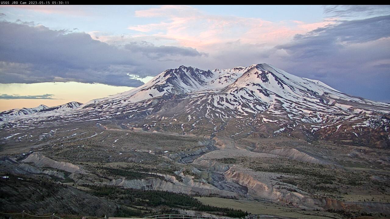
Johnston Ridge Observatory, Mount St. Helens
A debris flow in Mount St.

Nuvuk video camera 2 bright image
Two video cameras are installed atop a utility pole near the northernmost point of land in the United States at Nuvuk (Point Barrow), Alaska. The cameras point northwest toward the Arctic Ocean and the boundary between the Chukchi and Beaufort Seas. Every half hour during daylight hours, the cameras collect snapshots and video for 10 minutes.
Two video cameras are installed atop a utility pole near the northernmost point of land in the United States at Nuvuk (Point Barrow), Alaska. The cameras point northwest toward the Arctic Ocean and the boundary between the Chukchi and Beaufort Seas. Every half hour during daylight hours, the cameras collect snapshots and video for 10 minutes.

Nuvuk video camera 1 dark image
Two video cameras are installed atop a utility pole near the northernmost point of land in the United States at Nuvuk (Point Barrow), Alaska. The cameras point northwest toward the Arctic Ocean and the boundary between the Chukchi and Beaufort Seas. Every half hour during daylight hours, the cameras collect snapshots and video for 10 minutes.
Two video cameras are installed atop a utility pole near the northernmost point of land in the United States at Nuvuk (Point Barrow), Alaska. The cameras point northwest toward the Arctic Ocean and the boundary between the Chukchi and Beaufort Seas. Every half hour during daylight hours, the cameras collect snapshots and video for 10 minutes.

Nuvuk video camera 2 dark image
Two video cameras are installed atop a utility pole near the northernmost point of land in the United States at Nuvuk (Point Barrow), Alaska. The cameras point northwest toward the Arctic Ocean and the boundary between the Chukchi and Beaufort Seas. Every half hour during daylight hours, the cameras collect snapshots and video for 10 minutes.
Two video cameras are installed atop a utility pole near the northernmost point of land in the United States at Nuvuk (Point Barrow), Alaska. The cameras point northwest toward the Arctic Ocean and the boundary between the Chukchi and Beaufort Seas. Every half hour during daylight hours, the cameras collect snapshots and video for 10 minutes.

Nuvuk video camera 2 snapshop
Two video cameras are installed atop a utility pole near the northernmost point of land in the United States at Nuvuk (Point Barrow), Alaska. The cameras point northwest toward the Arctic Ocean and the boundary between the Chukchi and Beaufort Seas. Every half hour during daylight hours, the cameras collect snapshots and video for 10 minutes.
Two video cameras are installed atop a utility pole near the northernmost point of land in the United States at Nuvuk (Point Barrow), Alaska. The cameras point northwest toward the Arctic Ocean and the boundary between the Chukchi and Beaufort Seas. Every half hour during daylight hours, the cameras collect snapshots and video for 10 minutes.

Nuvuk video camera 1 time exposure
Two video cameras are installed atop a utility pole near the northernmost point of land in the United States at Nuvuk (Point Barrow), Alaska. The cameras point northwest toward the Arctic Ocean and the boundary between the Chukchi and Beaufort Seas. Every half hour during daylight hours, the cameras collect snapshots and video for 10 minutes.
Two video cameras are installed atop a utility pole near the northernmost point of land in the United States at Nuvuk (Point Barrow), Alaska. The cameras point northwest toward the Arctic Ocean and the boundary between the Chukchi and Beaufort Seas. Every half hour during daylight hours, the cameras collect snapshots and video for 10 minutes.