
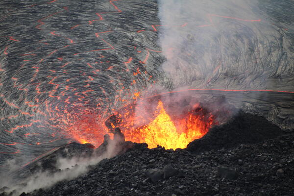
HVO scientists captured this zoomed-in photo of the western fissure within Halema‘uma‘u through the lens of a laser rangefinder on October 9, 2021. The fissure has formed a horseshoe-shaped spatter cone around its source, with an opening on the east (right) side allowing lava to flow into the active lava lake.
Images
Total: 0
Settings
Total: 0
Explore our planet through photography and imagery, including climate change and water all the way back to the 1800s when the USGS was surveying the country by horse and buggy.
Filter Total Items: 22040

October 9, 2021 — Kīlauea, summit eruptive vent
HVO scientists captured this zoomed-in photo of the western fissure within Halema‘uma‘u through the lens of a laser rangefinder on October 9, 2021. The fissure has formed a horseshoe-shaped spatter cone around its source, with an opening on the east (right) side allowing lava to flow into the active lava lake.

Economist coloring page
Natural Resource Economist coloring page.
By

October 8, 2021 — Kīlauea summit eruption
In this overflight photo of the Halema‘uma‘u lava lake, captured on October 8, 2021 and looking from the northeast, two western fissures are visible: one inactive from the December 2020–May 2021 Kīlauea summit eruption (center), and another actively feeding lava into the lake at this time (upper-right).
In this overflight photo of the Halema‘uma‘u lava lake, captured on October 8, 2021 and looking from the northeast, two western fissures are visible: one inactive from the December 2020–May 2021 Kīlauea summit eruption (center), and another actively feeding lava into the lake at this time (upper-right).

October 8, 2021 — Kīlauea summit eruption
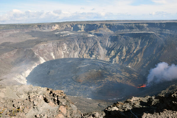
On the morning of October 8, 2021, HVO scientists completed a routine helicopter overflight of the ongoing eruption within Halema‘uma‘u at the summit of Kīlauea.
On the morning of October 8, 2021, HVO scientists completed a routine helicopter overflight of the ongoing eruption within Halema‘uma‘u at the summit of Kīlauea.

October 8, 2021 — Kīlauea summit eruption
Though not every ānuenue (rainbow) has an actively erupting volcanic fissure at its end, this one did for a brief moment during HVO scientists' helicopter overflight of the Kīlauea summit on the morning of October 8, 2021.
Though not every ānuenue (rainbow) has an actively erupting volcanic fissure at its end, this one did for a brief moment during HVO scientists' helicopter overflight of the Kīlauea summit on the morning of October 8, 2021.
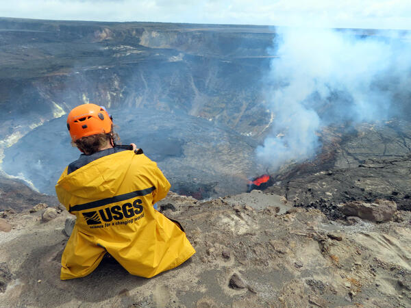
October 8, 2021 — Kīlauea summit eruption monitoring
USGS scientist takes video of the erupting west vent within Halema‘uma‘u crater, at the summit of Kīlauea. Photo taken from the northwest rim of Halema‘uma‘u at 12:27 p.m. HST on Oct. 8, 2021. USGS photo by J.M. Chang.
USGS scientist takes video of the erupting west vent within Halema‘uma‘u crater, at the summit of Kīlauea. Photo taken from the northwest rim of Halema‘uma‘u at 12:27 p.m. HST on Oct. 8, 2021. USGS photo by J.M. Chang.
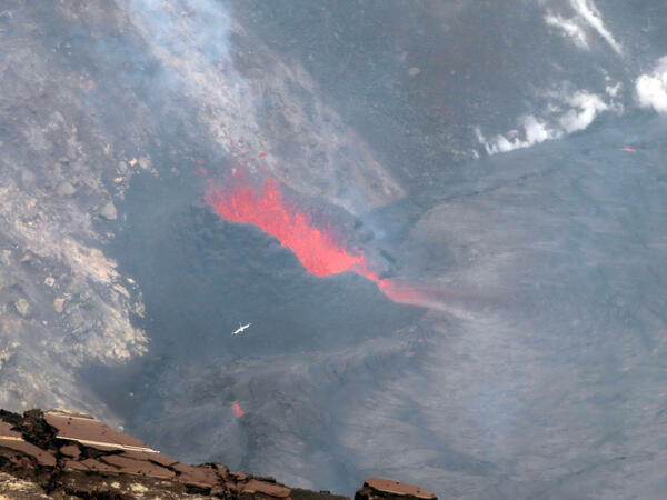
October 8, 2021 — Kīlauea, active west vent in Halema‘uma‘u crater
A Koa‘e Kea (white-tailed tropicbird) flies above the erupting west vent within Halema‘uma‘u crater, at the summit of Kīlauea. Photo taken from the south rim of Halema‘uma‘u at 10:41 a.m. HST on Oct. 8, 2021. USGS photo by J.M. Chang.
A Koa‘e Kea (white-tailed tropicbird) flies above the erupting west vent within Halema‘uma‘u crater, at the summit of Kīlauea. Photo taken from the south rim of Halema‘uma‘u at 10:41 a.m. HST on Oct. 8, 2021. USGS photo by J.M. Chang.
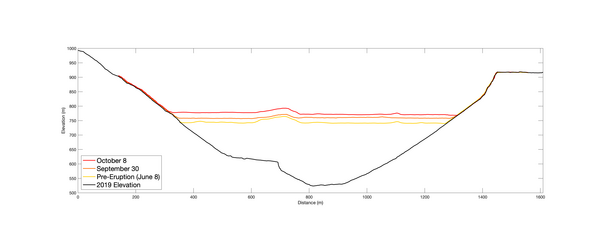
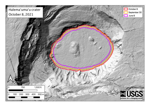
October 8, 2021 — Kīlauea, Halema‘uma‘u Lava Lake Depth
The elevation profiles running East-West across Halema‘uma‘u crater show the rise of the lava lake surface during the ongoing eruption at the summit of Kīlauea. The lake lake is now about 260 m (850 feet) deep, and has risen nearly 30 m (98 feet) above the previous lake surface since the eruption began on September 29.
The elevation profiles running East-West across Halema‘uma‘u crater show the rise of the lava lake surface during the ongoing eruption at the summit of Kīlauea. The lake lake is now about 260 m (850 feet) deep, and has risen nearly 30 m (98 feet) above the previous lake surface since the eruption began on September 29.
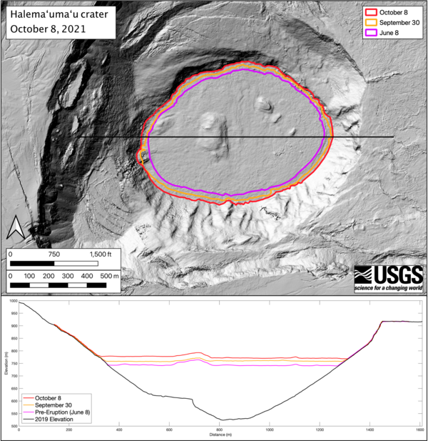
October 8, 2021 — Kīlauea, Halema‘uma‘u Lava Lake Growth
The eruption within Halema‘uma‘u crater, at Kīlauea's summit, continues to feed a growing lava lake. Photos taken during helicopter overflights of the crater allow HVO scientists to create elevation maps of the rising lake’s surface. The surface area of the Halema‘uma‘u lava lake is now 553000 square meters, or 157 acres.
The eruption within Halema‘uma‘u crater, at Kīlauea's summit, continues to feed a growing lava lake. Photos taken during helicopter overflights of the crater allow HVO scientists to create elevation maps of the rising lake’s surface. The surface area of the Halema‘uma‘u lava lake is now 553000 square meters, or 157 acres.
October 8, 2021 — Kīlauea, Halema‘uma‘u Lava Lake Growth
The surface area of the Halema‘uma‘u lava lake at the summit of Kīlauea is now 553,000 square meters, or 157 acres. At its widest point, the lake is a kilometer wide (0.62 mile).
The surface area of the Halema‘uma‘u lava lake at the summit of Kīlauea is now 553,000 square meters, or 157 acres. At its widest point, the lake is a kilometer wide (0.62 mile).
Kīlauea summit eruption in Halema‘uma‘u crater – October 7, 2021
A wide view of the ongoing Kīlauea summit eruption within Halema‘uma‘u, taken from the northwest rim of the crater. The west vent lava fountains (right) continues to supply lava into the slowly rising lava lake. Lava fountaining is no longer visible through the central and southern portions of the lava lake surface.
A wide view of the ongoing Kīlauea summit eruption within Halema‘uma‘u, taken from the northwest rim of the crater. The west vent lava fountains (right) continues to supply lava into the slowly rising lava lake. Lava fountaining is no longer visible through the central and southern portions of the lava lake surface.
Kīlauea summit eruption in Halemaʻumaʻu crater - October 7, 2021
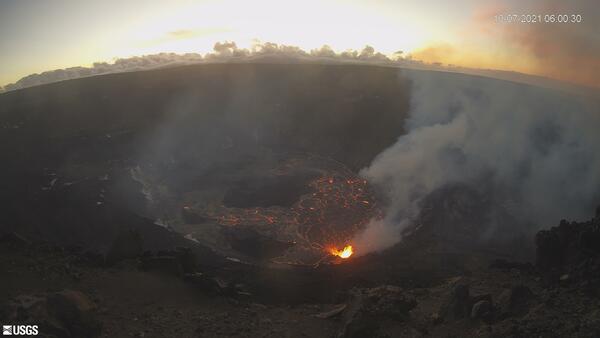
KWcam image taken on October 7, 2021, just after 6 a.m. HST. This image shows the ongoing eruption within Halemaʻumaʻu crater at the summit of Kīlauea. The eruption began the afternoon of September 29, 2021, as fissures in the floor of the crater; this activity is generating a lava lake that is slowly filling the crater.
KWcam image taken on October 7, 2021, just after 6 a.m. HST. This image shows the ongoing eruption within Halemaʻumaʻu crater at the summit of Kīlauea. The eruption began the afternoon of September 29, 2021, as fissures in the floor of the crater; this activity is generating a lava lake that is slowly filling the crater.

October 7, 2021 — Kīlauea
The eruption continues in Halema‘uma‘u crater, at the summit of Kīlauea. Lava fountaining no longer emerges from the central portion of the lake, with fountaining limited to the west vent shown here. Low fountaining within the cone supplies lava into the lake via a short spillway. USGS image by M. Patrick.
The eruption continues in Halema‘uma‘u crater, at the summit of Kīlauea. Lava fountaining no longer emerges from the central portion of the lake, with fountaining limited to the west vent shown here. Low fountaining within the cone supplies lava into the lake via a short spillway. USGS image by M. Patrick.

October 7, 2021 — Kīlauea eruption
The eruption continues in Halema‘uma‘u crater, at Kīlauea summit. This view from the southern crater rim shows the west vent fountains (center) supplying lava into the western portion of the lava lake. SO2 gas emission rates remain elevated, and were measured at 4,700 tonnes per day on October 7. USGS photo taken by L.
The eruption continues in Halema‘uma‘u crater, at Kīlauea summit. This view from the southern crater rim shows the west vent fountains (center) supplying lava into the western portion of the lava lake. SO2 gas emission rates remain elevated, and were measured at 4,700 tonnes per day on October 7. USGS photo taken by L.

October 7, 2021 — Kīlauea eruption
Late afternoon sunlight illuminates the main island in the lava lake in Halema‘uma‘u crater, at the summit of Kīlauea. The island formed in the previous summit eruption (December 2020-May 2021), and was covered with fresh spatter during the opening stages of the current eruption. USGS photo by M. Patrick.
Late afternoon sunlight illuminates the main island in the lava lake in Halema‘uma‘u crater, at the summit of Kīlauea. The island formed in the previous summit eruption (December 2020-May 2021), and was covered with fresh spatter during the opening stages of the current eruption. USGS photo by M. Patrick.

October 7, 2021 — Kīlauea eruption
This photo from Thursday, October 7, shows the lava lake near the western vent in Halema‘uma‘u crater, at the summit of Kīlauea. The zig zag pattern separating the crustal plates is evident here, as are several spreading zones which cut across the pattern. USGS photo by M. Patrick.
This photo from Thursday, October 7, shows the lava lake near the western vent in Halema‘uma‘u crater, at the summit of Kīlauea. The zig zag pattern separating the crustal plates is evident here, as are several spreading zones which cut across the pattern. USGS photo by M. Patrick.

October 7, 2021 — Kīlauea eruption
A view of the west vent in Halema‘uma‘u crater, at the summit of Kīlauea. This photo was taken from the northwest caldera rim, providing a good view inside the cone, as well as a view of the small spillway supplying lava into the lake. USGS photo by M. Patrick.
A view of the west vent in Halema‘uma‘u crater, at the summit of Kīlauea. This photo was taken from the northwest caldera rim, providing a good view inside the cone, as well as a view of the small spillway supplying lava into the lake. USGS photo by M. Patrick.

Crustal foundering in Halema‘uma‘u
A large crustal foundering event in Kīlauea's ongoing Halema‘uma‘u eruption occurred in the late afternoon on October 6, 2021. This photo was taken from the northwest crater rim looking east across the lava lake. USGS Photo: K. Lynn
A large crustal foundering event in Kīlauea's ongoing Halema‘uma‘u eruption occurred in the late afternoon on October 6, 2021. This photo was taken from the northwest crater rim looking east across the lava lake. USGS Photo: K. Lynn
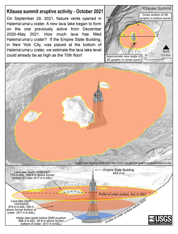
Halema‘uma‘u lava lake depth compared to Empire State Building
On September 29, 2021, fissure vents opened in Halema‘uma‘u crater. A new lava lake began to form on the one previously active from December 2020–May 2021.
On September 29, 2021, fissure vents opened in Halema‘uma‘u crater. A new lava lake began to form on the one previously active from December 2020–May 2021.

West vent fountain on October 6, 2021
The west vent fountain in Kīlauea's ongoing Halema‘uma‘u eruption was 12 m (39 ft) above the lava lake surface in the late afternoon of October 6, 2021. This photo was taken by USGS geologist K. Lynn from the northwest rim of Halema‘uma‘u looking south.
The west vent fountain in Kīlauea's ongoing Halema‘uma‘u eruption was 12 m (39 ft) above the lava lake surface in the late afternoon of October 6, 2021. This photo was taken by USGS geologist K. Lynn from the northwest rim of Halema‘uma‘u looking south.
Close-up view of west vent, Halema‘uma‘u, Kīlauea - October 5, 2021
Photo of fountaining from the western vent in Halema‘uma‘u crater, at the summit of Kīlauea. Spatter from the fountain continues to build up a horseshoe-shaped cone around the vent, with lava flowing into the lake at the base. This photo was taken from the western crater rim on October 5, 2021. USGS photo by N. Deligne.
Photo of fountaining from the western vent in Halema‘uma‘u crater, at the summit of Kīlauea. Spatter from the fountain continues to build up a horseshoe-shaped cone around the vent, with lava flowing into the lake at the base. This photo was taken from the western crater rim on October 5, 2021. USGS photo by N. Deligne.