
Eyes on Earth: Cities
Landsat and other Earth observing satellites play an important role in urban planning and change monitoring. Nearly 60 percent of the world's human population now lives in areas of contiguous urban development. City growth alters entire landscapes including land surface, vegetation, water cycle, radiant heat and other aspects.
Episode 118 – Preparing for Landsat Next, Part 2

In this episode, we talk with several people involved with the next Landsat mission, targeted for launch around 2030. While that may seem like a ways into the future, it takes a lot of work to prepare for such a big mission. In Part 2 of this two-part series on Landsat Next, we’ll hear about what needs to be done before launch to prepare the ground system, data processing and data calibration. Be sure to also listen to Part 1, where we talk about how different Landsat Next will be from previous Landsat missions, and what scientists are really looking forward to with this mission.
Guests: Brian Sauer, USGS Landsat Next Project Manager at EROS; Chris Engebretson, USGS Acting Ground System Manager for Landsat Next at EROS; Cody Anderson, USGS EROS Calibration and Validation Center of Excellence Project Manager
Host: Tom Adamson (contractor for USGS EROS)
Release date: Monday, May 6, 2024
Episode 117 – Preparing for Landsat Next, Part 1

In this episode, we talk with several people involved with the next Landsat mission. In Part 1, we’ll hear about how different Landsat Next will be from previous Landsat missions and how its additional spectral bands, higher resolution, and 6-day revisit will benefit science and society. Addressing the needs of the Landsat user community was a high priority in developing the mission, so we talk about what scientists are really looking forward to with Landsat Next. The Part 2 episode shares details about technical preparations, such as the ground system and data processing and validation.
Guests: Tim Newman, USGS Program Coordinator for National Land Imaging; Zhuoting Wu, USGS Earth Observation Applications Coordinator for National Land Imaging; Chris Crawford, USGS Research Physical Scientist
Host: Tom Adamson (contractor for USGS EROS)
Release date: Monday, April 22, 2024
Episode 113 – EROS Science Leader’s Vision

Terry Sohl helped develop the National Land Cover Database, NLCD, when he first arrived, and now he’s overseeing significant improvements to the widely used product. But that’s just one part of his new role. In this episode, Sohl provides an overview of the science efforts at EROS and how artificial intelligence and machine learning help scientists focus more on the work that helps society. He also shares his vision for the future.
Guest: Terry Sohl, Chief of the USGS EROS Integrated Science and Applications Branch
Host: Jane Lawson (contractor for USGS EROS)
Release date: Monday, February 26, 2023
Episode 80 – ECOSTRESS and Carbon
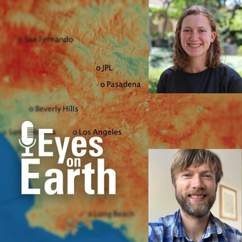
ECOSTRESS, which stands for the ECOsystem Spaceborne Thermal Radiometer Experiment on Space Station, collects land surface temperatures in an effort to answer questions about plants’ use of water. The NASA Land Processes Distributed Active Archive Center (LP DAAC) at EROS has provided storage and distribution of ECOSTRESS data for four years now and counting. In this episode, we’ll take a look at how the ECOSTRESS temperature measurements can be useful in characterizing biological influences on the carbon dioxide exchange, specifically in the urban environment of Los Angeles and the non-urban environment surrounding the city.
Guests: Nick Parazoo, NASA Jet Propulsion Laboratory; Willow Coleman, former NASA JPL intern
Host: Jane Lawson
Release date: September 28, 2022
Episode 55 – Urban Heat Islands of New York

In this episode, we learn how New York City uses Landsat to pinpoint city hot spots. Urban heat islands occur in areas containing more impervious surfaces and fewer natural environments. The day and night surface temperature are higher in urban heat islands than in surrounding areas.
During heat waves, this can lead to greater numbers of heat-related illnesses and deaths. Landsat satellites collect data on surface temperature and vegetative change that can help cities mitigate the heat stresses for residents, especially in a warming climate. For this episode of Eyes on Earth, we hear about how a mapping project involving Landsat data helped the New York City Council identify urban heat islands.
Guests: Dr. Christian Braneon, a remote sensing specialist at NASA’s Goddard Institute for Space Studies, and James Cottone, a New York City Council resiliency planner
Host: Jane Lawson
Release date: July 26, 2021