
The Role of Sediment in Coastal Resiliency
The delivery and deposition of sediment along coastlines is essential to building barriers such as sandbars, dunes and marshes that protect coastal communities from storms and sea-level rise.

Researchers at the USGS Pacific Coastal Marine Science Center (PCMSC) and colleagues are investigating how human-caused changes to major West coast rivers have altered sediment delivery and deposition in California’s San Francisco Bay and Skagit Bay in the Puget Sound region of Washington State.


At their most basic, rivers are conduits of water, transporting it from high to low ground. Suspended in this water is sediment—in many cases, a lot of it. Around the world, rivers flowing to the ocean deliver hundreds of billions of tons of sediment each year to coastal areas. This sediment supplies the material for marshes, sandbars, dunes, barrier islands and other landforms that shield coastlines from waves and storms.
When humans alter the landscape and contribute to climate-fueled storms and rising sea levels, that supply of sediment can be hastened, redirected or lost altogether. The sediment supply, storage or loss often changes in response to land-use practices.
Along much of the West Coast, a legacy of clear-cutting, diking and dam-building has left lasting marks on the landscape. All affect the sediment amounts in different ways. Dams hold back not only water but the sediment within it, cutting off the supply to lower reaches of the river. Dikes and channels at the river mouth, built to keep tidewater out of agricultural land, focus the river’s flow into the ocean. This translates to less sediment accumulating alongshore, hastening erosion.
Clear-cutting strips the land of its soil-retaining plant cover and sends a glut of sediment down waterways and into the ocean. Hydraulic mining, a practice made popular in the 1800s by California gold-seekers, has a similar effect. Sediment released by these activities poured into bays and estuaries, smothering native ecosystems and clogging navigation corridors along the entire U.S. West Coast.
Land-use changes in the past 150 years—including the construction of dikes, levees and extensive channels to prevent flooding and enable development along bays and estuaries—have significantly altered how this outpouring of sediment is deposited. San Francisco Bay, for example, appears to have the opposite problem: the sediment lost by those former human activities is gone, having run its course out to sea.
“The Sacramento and San Joaquin Rivers deliver half the amount of sediment they did 50 years ago,” said Jessica Lacy, a research oceanographer at PCMSC. “Just as sea-level rise is accelerating, the demand for sediment is growing.”
The amount of sediment supplied to estuaries is important to the fate of shallow water habitats, including mudflats and tidal marshes. In San Francisco Bay, scientists and collaborators from PCMSC and the USGS Western Ecological Research Center (WERC) are investigating the influence of tides, waves, and water levels on sediment delivery and deposition in Whale’s Tail marsh, a wave-exposed tidal salt marsh in south San Francisco Bay.

“Our wetlands provide this unique opportunity to protect us from rising seas by trapping sediment and building up elevation to keep pace with sea-level rise,” said Karen Thorne, a research ecologist at the USGS WERC and a co-lead of the San Francisco Bay study. “They continue to build up as the oceans get higher. A lot of other coastal ecosystems, such as coastal bluffs and beaches, can’t do that. Therefore, it’s important to know if there’s enough sediment available in the bay and if it’s being deposited on the wetlands, rather than ending up elsewhere.”
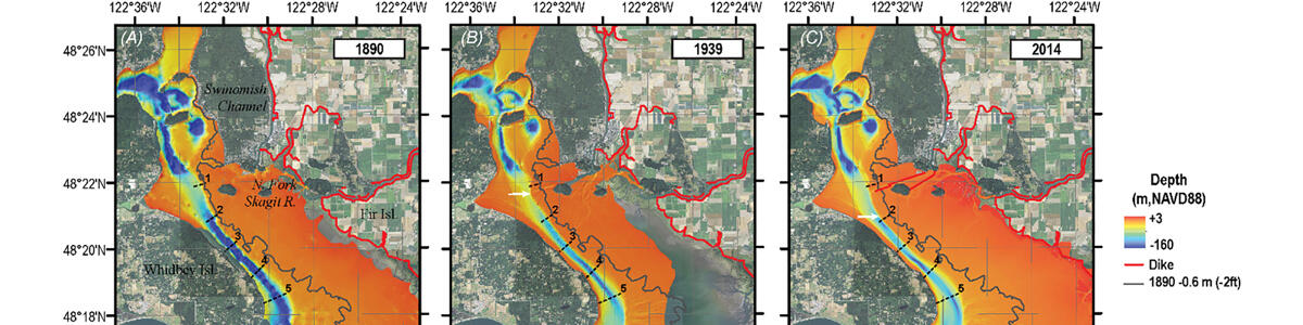
In Skagit Bay, part of Washington’s Puget Sound, land-use changes over the past century—including heavy logging and channelization of the Skagit River, the largest river in Puget Sound—have transformed the river delta.
Following the high-sediment yields that resulted from clear-cutting, Skagit Bay was extensively dredged and channelized to permit shipping traffic. A network of dikes, canals and levees were constructed on the Skagit River Delta to hold back tidewaters. These developments focused the flow of sediment from the river offshore to deep basins in Puget Sound, turning a formerly calm depositional environment at the delta to a more energetic one, with coarser sediment that is deposited further offshore.


“The sediment is no longer being deposited on the emergent Skagit River Delta, which represents a lost resource for an area that has subsided one to two meters and is facing increasing vulnerability to sea level rise,” said Eric Grossman, a research geologist with PCMSC and lead author of a study using analyses of historical bathymetric change (the amount the “floor” or “bed” of the river changes through time), sediment core stratigraphy, and coastal-change modeling to investigate the sediment load of the Skagit River Delta.
“Conventional flood protection, in the form of levees and dikes constructed along the Skagit River and Bay, has the unintended effect of accelerating sediment export and erosion, threatening coastal resiliency in this area as sea levels continue to rise,” said Grossman.
The Skagit River Delta and San Francisco Bay studies point to the need for improved understanding of sediment amounts and the role of waves and currents in driving sediment transport in bays and river deltas along the West coast. The ability to evaluate and predict how sediments will affect shoreline stability and coastal ecosystem functions (e.g., dune formation, sediment deposition on salt marshes) is expected to be increasingly important for communities to plan for and mitigate impacts expected with sea-level rise.
Related Content

Sediment Transport in Coastal Environments

Sediment transport between estuarine habitats in San Francisco Bay

Estuaries and large river deltas in the Pacific Northwest
Related Content
Sediment Transport in Coastal Environments
Sediment transport between estuarine habitats in San Francisco Bay
Estuaries and large river deltas in the Pacific Northwest
Get Our News
These items are in the RSS feed format (Really Simple Syndication) based on categories such as topics, locations, and more. You can install and RSS reader browser extension, software, or use a third-party service to receive immediate news updates depending on the feed that you have added. If you click the feed links below, they may look strange because they are simply XML code. An RSS reader can easily read this code and push out a notification to you when something new is posted to our site.