
Travels with Sediment in the San Francisco Bay, Delta, and Coastal System
Special Issue of the scientific journal Marine Geology Focuses on Complex Urbanized Estuary and Coast

by Barbara Wilcox and Helen Gibbons
Wherever water flows, it almost always carries sediment—particles of sand, silt or clay that flow, scour, accumulate and disperse to help form and reform Earth’s features over time. Sediment helps to create natural habitats and to alter geography, and an understanding of its complex processes is key to many planning and conservation decisions.
In the San Francisco Bay Area—an estuarine region defined by its bay, rivers, delta and coast—sediment plays a particularly major role. Sediment helps shape the Bay Area’s quality of life, from its water quality to its coastal beaches to the ongoing restoration of its tidal wetlands. Dams, dredging and a legacy of hydraulic mining have left their marks on the Bay Area’s system of “sediment transport”—the scientific term for the water-borne movement of sediment from place to place—making U.S. Geological Survey science crucial to charting the potential impacts of future human interventions. Yet the Bay Area’s complex sediment-transport processes have never before been comprehensively studied on a regional scale.
“The interaction of natural and anthropogenic drivers of sediment transport is highly complex in this heavily urbanized region, and understanding it is critical to the efficient management of sediment resources that affect beaches, tidal-wetland restoration, and sensitive ecosystems throughout the region,” said Patrick Barnard, USGS coastal geologist and managing guest editor of the special issue. “We hope that this special issue will be instrumental in guiding management decisions for years to come.”
A History of Sediment
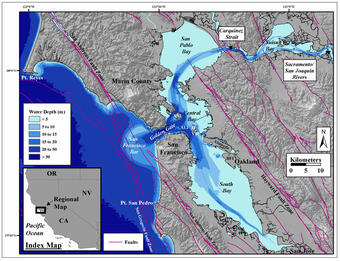
In the late 19th century, the high-pressure jets of water used for hydraulic gold mining pulverized large swaths of the Sierra Nevada foothills and sent trillions of cubic feet of gravel, sand, and mud 150 miles downstream into San Francisco Bay and then into the Pacific Ocean. The sediment changed local landforms by building out Bay shorelines and tidal wetlands, accreting river channels, and adding to the huge, submerged sand bar outside the Golden Gate. This gigantic sediment pulse has taken more than a century to flow through the system. Now that the Gold Rush sediment is on its way out and the water is clearer, scientists are evaluating how the Bay Area’s natural processes and quality of life will change.

Biological Effects

Sediment influences how hospitable water is to certain organisms. Sediment-laden waters are preferred by some wildlife species, notably the endangered Delta Smelt. In the Bay Area, sediment suspended in bay and delta water has also performed the welcome function of making the water less prone to algal blooms. As the water’s sediment content has declined in the last couple of decades, its algae count has risen. This phenomenon has been most pronounced in El Niño years of heavy rain. Discharges or diversions of water from various parts of California’s complex water-resources infrastructure can also affect this sensitive balance. To understand the ever-shifting water and sediment dynamics of the San Francisco Bay and delta, and to help managers plan, the USGS deployed automated instruments that have continually measured suspended-sediment concentration, temperature, salinity, and water level at many sites throughout the bay and delta since the 1980s, producing the longest continuous estuarine water-quality data set in history and a model for water-quality monitoring programs throughout the world.
“The USGS data set is a cornerstone of our Federal, State, and local agency collaborative monitoring program,” said Thomas Mumley, Assistant Executive Officer of California’s San Francisco Bay Regional Water Quality Control Board. “It continues to inform major management actions and decisions on water-quality control, dredging, and habitat restoration.”
Physical Changes
Complementing sediment’s biological effects are its physical effects. Sediment carried through the bay to the Pacific nearshore replenishes beaches eroded by coastal waves. In the far north and south reaches of San Francisco Bay, sediment helps to restore tidal marshes lost to former salt ponds by counteracting local sinking caused by historical groundwater pumping, in effect elevating the ground so that it remains in the tidal zone, where tide-adapted plants and animals thrive. With the giant sediment pulse from hydraulic mining largely past, these processes of replenishment and restoration must now rely on smaller and more localized sediment sources. USGS research aims to chart how sustainable California beaches will be, and how long it will take to restore bay wetlands, in light of the region’s changing sediment budget.
Useful to Land Managers and Planners

“The information provided in the Marine Geology special issue has fundamentally changed the way managers are thinking about the sediment supply to San Francisco Bay and the outer coast, and how we manage projects,” said Brenda Goeden, Sediment Program Manager of California’s San Francisco Bay Conservation and Development Commission. “For example, the suspended-sediment research is helping managers understand how sediment supply will affect habitat restoration projects around the Bay that are funded by millions of public dollars, and it offers a rare opportunity to intervene where sediment supply may not support a given restoration site in the face of rising seas. Similarly, the coarse-grained-bedload findings inform policy analysis of projects proposing to extract large quantities of coarse-grained sediment from the Bay system.”
The amount and character of sediment is affected by waves, which are shaped partly by underwater landforms that, in turn, owe their forms to past sediment deposition. The submerged sand bar outside the Golden Gate alters nearshore waves by refracting or bending their paths and causing the waves to break as the water gets shallow (shoals). The sand bar is expected to continue shrinking in future decades owing to the combined effects of reduced sediment and projected sea-level rise. This shrinkage, in turn, is likely to alter wave behavior and thus expose the coastline for many miles south to more aggressive and potentially erosive wave action.
Studying sediment transport trains a special lens on San Francisco’s bay, delta and nearshore as part of a fluid and interconnected system. Human intervention has altered the sediment budget and thus the whole environment in ways unforeseen in the 19th century. USGS science aims to understand this changing and complex system and to give managers tools to address future change.
“What had previously been a black box for managers is now becoming clearer,” said Goeden. “Three cheers for the work that has been so well researched and clearly explained!”
The complete special issue of Marine Geology, with 21 articles, is available online.
A multi-discipline approach for understanding sediment transport and geomorphic evolution in an estuarine-coastal system: San Francisco Bay, edited by P.L. Barnard, B.E. Jaffe and D.H. Schoellhamer, volume 345, pages 1–326 (1 November 2013).
Selected Papers from Marine Geology Special Issue:
Adjustment of the San Francisco estuary and watershed to decreasing sediment supply in the 20th century: Because of hydraulic mining and subsequent development, the San Francisco estuary and watershed experienced a period of increasing sediment supply beginning in 1852 and decreasing sediment supply by the late 1900s. The San Francisco Bay Area has followed the typical progression of human land use in coastal watersheds of initial disturbance (deforestation, mining, agricultural expansion, overgrazing, and urbanization) that creates a sediment pulse to an estuary followed by dams that reduce sediment supply. Conceptual models and syntheses of other studies show how the estuary and watershed have adjusted to decreasing sediment supply.
Comparison of sediment supply to San Francisco Bay from watersheds draining the Bay Area and the Central Valley of California: A comprehensive, quantitative analysis of sediment supply to San Francisco Bay shows that local, urbanized watersheds now contribute more suspended sediment to San Francisco Bay than the large Sacramento and San Joaquin rivers draining California’s Central Valley. If San Francisco Bay is typical of other estuaries in active tectonic or climatically variable coastal regimes, managers responsible for water quality, dredging and reusing sediment accumulating in shipping channels, or restoring wetlands in the world’s estuaries may need to more carefully account for nearby small urbanized watersheds that may dominate sediment supply.
Integration of bed characteristics, geochemical tracers, current measurements, and numerical modeling for assessing the provenance of beach sand in the San Francisco Bay coastal system: The authors established the sources of beach-sized sand in the San Francisco Bay coastal system, the places where it has been deposited, and the transport pathways it has followed. Their work highlights the regional impact of a sharp reduction in sediment from historic hydraulic mining in the Sierra Nevada and the need to more efficiently manage existing in-bay sediment resources. Informed management of sediment resources can promote the sustainability of fringing tidal wetlands and beaches, the first line of defense as sea level rises and potentially larger storms increase the vulnerability of coastal environments over the next century and beyond.
Get Our News
These items are in the RSS feed format (Really Simple Syndication) based on categories such as topics, locations, and more. You can install and RSS reader browser extension, software, or use a third-party service to receive immediate news updates depending on the feed that you have added. If you click the feed links below, they may look strange because they are simply XML code. An RSS reader can easily read this code and push out a notification to you when something new is posted to our site.