
Drs. Donya Frank-Gilchrist and Legna Torres-García were funded to assess the feasibility for international collaborations on natural hazards investigations in the Caribbean
Drs. Donya Frank-Gilchrist and Legna Torres-García of the St. Petersburg Coastal and Marine Science Center (SPCMSC) are co-leading the project entitled “Stakeholder Engagement for Natural Hazards Investigations in the Caribbean (SENHIC),” jointly funded by the USGS Risk Community of Practice and the United States Agency for International Development’s (USAID) Bureau for Humanitarian Assistance.
The goals of this project are to connect with natural hazards researchers and local experts in U.S. territories and other Caribbean countries to find out which natural hazards are of primary concern, learn about their mitigation efforts, and explore the potential for research collaboration.
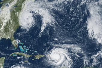
U.S. Caribbean territories are severely impacted by natural hazards which exacerbate preexisting socioeconomic vulnerabilities and health risks. These hazardous conditions are expected to worsen with climate change. Some natural hazards impacting these small islands are driven by regional-scale processes that are linked to those of neighboring countries. Investigating hazards such as coastal storms, flooding, sea level rise, freshwater scarcity, earthquakes, droughts, and coral reef degradation at a regional scale with collaborators will help to better understand these physical processes and develop more accurate numerical models to reduce loss of life and property.
The team will connect with other USGS scientists who have conducted natural hazards research in the Caribbean, and with local experts in the U.S. Caribbean territories and other Caribbean countries to learn about the natural hazards of primary concern, mitigation efforts, and areas of overlapping interest. In conjunction with the USGS Office of International Programs and the Caribbean-Florida Water Science Center, they will develop a framework for collaborating with international partners on natural hazards research in the Caribbean. Additionally, a database of local experts and a list of regional natural hazard resources will be compiled to lay the groundwork for future potential collaborations. The team plans to produce a final report documenting engagement strategies, best practices, key takeaways, and lessons learned. This project is being jointly funded by the Risk CoP and the USAID’s Bureau for Humanitarian Assistance. Drs. Frank-Gilchrist and Torres-García hope that this project will lay the foundation for future collaborations and information exchange to build capacity for resilience across the Caribbean region.
Get Our News
These items are in the RSS feed format (Really Simple Syndication) based on categories such as topics, locations, and more. You can install and RSS reader browser extension, software, or use a third-party service to receive immediate news updates depending on the feed that you have added. If you click the feed links below, they may look strange because they are simply XML code. An RSS reader can easily read this code and push out a notification to you when something new is posted to our site.