
Landsat 7 Celebrates Silver Anniversary
On April 15, 1999, the Landsat 7 satellite launched into space carrying the Enhanced Thematic Mapper Plus (ETM+) sensor onboard. For 25 years the satellite has been orbiting our planet and capturing images that help scientists and land managers monitor changes in land cover and aid in natural disaster response.

Landsat 7 has made over 132,000 trips around the Earth and contributed more than 3.3 million Level-1 scenes to the USGS EROS Archive.
The first light image captured by Landsat 7 was over Southeast South Dakota on April 18, 1999. The color infrared image below shows the Missouri River flowing from the middle left of the image to the lower right, where Fort Randall Dam created Lake Francis Case.

ETM+ Sensor Faces Challenges
Four years after launch, the Scan Line Corrector (SLC) on the ETM+ failed. Since the SLC compensated for the forward motion of the satellite, this failure caused the sensor’s line of sight to trace a zig-zag pattern along the satellite ground track. As a result, the imaged area is duplicated, with a width that increases toward the edge of the scene. When L7 Level-1 products are processed, the duplicated areas are removed, leaving data gaps.
Even with the gaps, 78 percent of the scene’s pixels are still useable and are considered some of the most geometrically and radiometrically accurate civilian satellite data in the world.

Advances that came with Landsat 7
Landsat 7 carried the ETM+ instrument, the most sophisticated Landsat sensor at the time. The ETM+ included a 15-meter(m) panchromatic band and a thermal band with improved spatial resolution, refined to 60 m from the earlier sensors 120 m. For the first time in the Landsat program history, Landsat 7 was equipped with hardware that could reliably store large amounts of imaged data onboard for later download when a ground station was in range.
Landsat 7 offered improved geometric and radiometric calibration compared to its predecessors. Onboard, Landsat 7 added partial and full-aperture solar calibrators. On the ground, Landsat 7 was the first Landsat mission to incorporate a data-trending image assessment system into an operational ground system. It also carried a new solid-state data recorder, which was the first to fly on a civilian mission. This all paved the way for major advancements for Landsat 8 and 9.
Significant captures by Landsat 7
While the ETM+ sensor captured many landscape changes such as fires, floods, deforestation, and urban growth over its 25 years, a few notable events captured include:
- On June 19, 2001, Landsat 7 captured the path of destruction caused by an EF3 tornado that passed near Siren, Wisconsin on June 18, 2001.

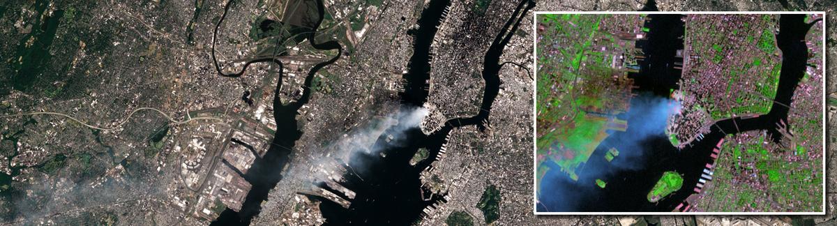
- On September 12, 2001, Landsat 7 captured the aftermath of one of the most tragic events to take place in the United States—the collapse of the Twin Towers of the World Trade Center in New York City on September 11, 2001.
- Hurricane Katrina—a Category 3 storm with sustained winds of 125 mph (200 kilometers) — hit the City of New Orleans, Louisiana, on August 28, 2005. A few weeks later, on September 15, 2005, Landsat 7 captured images of the destruction to the coastline and city. The image below shows the large area of flooding around New Orleans at the bottom right.

- In support of the International Polar Year (IPY 2007-2008), the Landsat Image Mosaic of Antarctica (LIMA) was released. This is the first-ever 15-meter resolution, true color image of Antarctica. It was constructed from nearly 1,100 individually selected Landsat 7 ETM+ scenes. Each image was orthorectified and adjusted for geometric, sensor and illumination variations to a standardized, almost seamless surface reflectance product. Multiple color composites and enhancements were generated to illustrate multiple dimensions of the multispectral data including: the true appearance of the surface; discrimination between snow and bare ice; reflectance variations within saturated snow; and subtle topographic variations associated with ice flow.

- On April 20, 2010, an explosion on the Deepwater Horizon oil rig in the Gulf of Mexico resulted in a major oil spill about 250 miles southeast of Houston, Texas. Landsat 7 captured the extent of the oil slick on May 1, 2010. More than 4 million barrels of oil were released into the ocean.

Landsat 7 Adjusts Orbit for Landsat 9
After Landsat 9 successfully launched in 2021, Landsat 7’s orbit was lowered from 438 miles/705 kilometers (km) to 433.1 miles/697 km. Landsat 7’s ETM+ resumed imaging on May 5, 2022, and started the Landsat 7 extended science mission. As expected, Landsat 7 would drift within its orbit and be exposed to long periods of full sunlight. This impacted imaging opportunities and Landsat 7’s ability to provide valid science data. In January 2024, imaging was suspended to retain the health and safety of the satellite due to full sunlight exposure causing issues with the batteries. Today, the satellite remains in full sunlight. Learn more about Landsat 7 extended science mission here.
Related Content

Eyes on Earth Episode 85 – Landsat 7 Extended Science Mission
Related Content
Eyes on Earth Episode 85 – Landsat 7 Extended Science Mission
Get Our News
These items are in the RSS feed format (Really Simple Syndication) based on categories such as topics, locations, and more. You can install and RSS reader browser extension, software, or use a third-party service to receive immediate news updates depending on the feed that you have added. If you click the feed links below, they may look strange because they are simply XML code. An RSS reader can easily read this code and push out a notification to you when something new is posted to our site.