

Before and after imagery of the original Franklin Extensometer. The original Franklin extensometer measured aquifer compaction near the groundwater pumping center at Franklin, Virginia from 1979 to 1995.
1940s Monitoring Well in Franklin, Virginia
By Virginia and West Virginia Water Science Center
1945 (approx.)

Detailed Description
Under natural conditions, water levels in wells completed in many confined aquifers rise above the land surface, resulting in artesian flow. The well shown in the photograph was drilled near Franklin, Virginia, in 1941 to a depth of about 600 feet in confined aquifers. The initial water level in the well was about 7 feet above land surface. The above-ground structure shown in the photograph (Cederstrom, 1945) was built in the 1940’s as a creative solution to measure the water level in this well. Measurements at the well were discontinued in 1960. Today, measurements at other nearby wells indicate that water levels are now 150 to more than 200 feet below land surface.
Sources/Usage
Public Domain.
Photo credit: Cederstrom, 1945
Related Content
Check out more modern images of our Franklin Extensometer research site below:
Before and after imagery of the original Franklin Extensometer. The original Franklin extensometer measured aquifer compaction near the groundwater pumping center at Franklin, Virginia from 1979 to 1995.
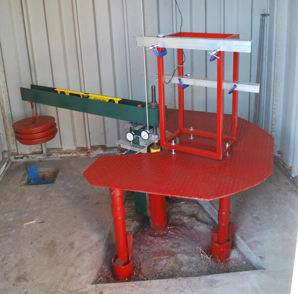
The USGS Franklin pipe extensometer with a total depth of 860 feet.
The USGS Franklin pipe extensometer with a total depth of 860 feet.
Period of record: 1979-1995; 2016-present
The USGS Franklin pipe extensometer with a total depth of 860 feet.
Period of record: 1979-1995; 2016-present

Building housing the USGS Franklin extensometer
Building housing the USGS Franklin extensometer. Inside, the extensometer extends 866 feet below land surface.
Period of record: 1979-1995; 2016-present
Building housing the USGS Franklin extensometer. Inside, the extensometer extends 866 feet below land surface.
Period of record: 1979-1995; 2016-present

USGS Scientists Inspect A Research Site in Franklin, Virginia
USGS Scientists inspect the Franklin Extensometer research site in 2015. The extensometer at Franklin had been measuring land subsidence since 1979 but had been offline since 1995 and would be brought back online the following year.
USGS Scientists inspect the Franklin Extensometer research site in 2015. The extensometer at Franklin had been measuring land subsidence since 1979 but had been offline since 1995 and would be brought back online the following year.

2015 Franklin Extensometer Aquifer Rebound Damage
Photo of the original Franklin extensometer taken during an inspection in 2015. Recording had ended in 1995, and between 1995 and 2015, groundwater pumping rates lessened causing the aquifer to briefly recover and the land to rebound. This rebound was so significant that it caused the damage to the extensometer seen above.
Photo of the original Franklin extensometer taken during an inspection in 2015. Recording had ended in 1995, and between 1995 and 2015, groundwater pumping rates lessened causing the aquifer to briefly recover and the land to rebound. This rebound was so significant that it caused the damage to the extensometer seen above.

Franklin Extensometer Historical Photo
Image of the original extensometer at Franklin, Virginia, which recorded aquifer compaction from 1979 to 1995.
Originally published in:
Image of the original extensometer at Franklin, Virginia, which recorded aquifer compaction from 1979 to 1995.
Originally published in:
Related Content
Check out more modern images of our Franklin Extensometer research site below:
Before and After: Franklin Extensometer
Before and after imagery of the original Franklin Extensometer. The original Franklin extensometer measured aquifer compaction near the groundwater pumping center at Franklin, Virginia from 1979 to 1995.
Before and after imagery of the original Franklin Extensometer. The original Franklin extensometer measured aquifer compaction near the groundwater pumping center at Franklin, Virginia from 1979 to 1995.
The USGS Franklin pipe extensometer with a total depth of 860 feet.
The USGS Franklin pipe extensometer with a total depth of 860 feet.
Period of record: 1979-1995; 2016-present
The USGS Franklin pipe extensometer with a total depth of 860 feet.
Period of record: 1979-1995; 2016-present
Building housing the USGS Franklin extensometer
Building housing the USGS Franklin extensometer. Inside, the extensometer extends 866 feet below land surface.
Period of record: 1979-1995; 2016-present
Building housing the USGS Franklin extensometer. Inside, the extensometer extends 866 feet below land surface.
Period of record: 1979-1995; 2016-present
USGS Scientists Inspect A Research Site in Franklin, Virginia
USGS Scientists inspect the Franklin Extensometer research site in 2015. The extensometer at Franklin had been measuring land subsidence since 1979 but had been offline since 1995 and would be brought back online the following year.
USGS Scientists inspect the Franklin Extensometer research site in 2015. The extensometer at Franklin had been measuring land subsidence since 1979 but had been offline since 1995 and would be brought back online the following year.
2015 Franklin Extensometer Aquifer Rebound Damage
Photo of the original Franklin extensometer taken during an inspection in 2015. Recording had ended in 1995, and between 1995 and 2015, groundwater pumping rates lessened causing the aquifer to briefly recover and the land to rebound. This rebound was so significant that it caused the damage to the extensometer seen above.
Photo of the original Franklin extensometer taken during an inspection in 2015. Recording had ended in 1995, and between 1995 and 2015, groundwater pumping rates lessened causing the aquifer to briefly recover and the land to rebound. This rebound was so significant that it caused the damage to the extensometer seen above.
Franklin Extensometer Historical Photo
Image of the original extensometer at Franklin, Virginia, which recorded aquifer compaction from 1979 to 1995.
Originally published in:
Image of the original extensometer at Franklin, Virginia, which recorded aquifer compaction from 1979 to 1995.
Originally published in: