
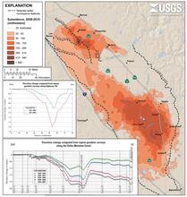
2008-2010 Land Subsidence Contours, San Joaquin Valley, California
By Land Subsidence in California
2016 (approx.)

Detailed Description
Land subsidence contours showing vertical changes in land surface in the central San Joaquin Valley area, California, during January 8, 2008-January 13, 2010. The top graph illustrates elevation changes computed from repeat geodetic surveys along Highway 152 for 1972-2004. The bottom graph depicts elevation changes computed from repeat geodetic surveys along the Delta-Mendota Canal for 1935-2001. Subsidence data along Highway 152 were computed from published National Geodetic Survey elevations. Subsidence graph for the Delta-Mendota Canal was obtained from the San Luis and Delta-Mendota Water Authority and the Central California Irrigation District
Sources/Usage
Public Domain.