
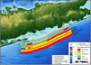
Coastal Vulnerability Index offshore Fire Island, NY

Detailed Description
The Coastal Vulnerability Index (CVI) provides insight into the relative potential of coastal change due to future sea-level rise. The maps and data presented here can be viewed in at least two ways: 1) as an example of where physical changes are most likely to occur as sea-level rises; and 2) as a planning tool for Fire Island National Seashore.
Sources/Usage
Public Domain.