
CoSMoS Implementation versions

Detailed Description
The Coastal Storm Modeling System (CoSMoS) makes detailed predictions (meter-scale) over large geographic scales (100s of kilometers) of storm-induced coastal flooding and erosion for both current and future SLR scenarios, as well as long-term shoreline change and cliff retreat. Resulting projections for future climate scenarios (sea-level rise and storms) provide emergency responders and coastal planners with critical storm-hazards information that can be used to increase public safety, mitigate physical damages, and more effectively manage and allocate resources within complex coastal settings.
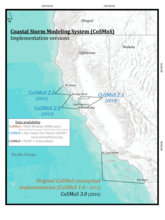
Several versions of CoSMoS have been implemented for areas of the California coast, including Southern California, Central California, and San Francisco Bay, and are outlined on this map. Further versions will be incorporated as additional regions and improvements are developed.
Data for the various CoSMoS versions and supporting investigations are available on the USGS ScienceBase Catalog, on the Our Coast, Our Future website (OCOF), and on the CoSMoS website, as detailed on this map.
Erikson, L.H., Barnard, P.L., O’Neill, A.C., Vitousek, S., Limber, P., Foxgrover, A.C., Herdman, L.H., and Warrick, J., 2017A, CoSMoS 3.0 Phase 2 Southern California Bight: Summary of data and methods: USGS data release, doi: 10.5066/F7T151Q4
Sources/Usage
Public Domain.