
Elwha River delta mapping

Detailed Description
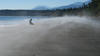
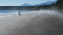
Diana McCandless of the Washington State Department of Ecology pauses for a moment, on the beach around the point and to the east of the mouth of Elwha River. McCandless is part of a team of scientists from WA State and the USGS who are periodically mapping the delta and beach areas near the mouth of the Elwha River. The scientists are monitoring how sediment is being redistributed throughout this coastal area, following the removal of the river's two dams (dam removal project completed in 2014). Port Angeles Transfer and Recycling is in the far background.
Sources/Usage
Public Domain.