
Field survey methods

Detailed Description
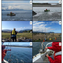
Photos of survey equipment used during surveys of the Elwha River delta, Washington, from 2010-2017, showing:
A, personal watercraft,
B, kayak each equipped with global navigation satellite system (GNSS) receivers and single-beam echosounders,
C, GNSS receiver mounted on a backpack,
D, GNSS base station,
E, collection of surface sediment sample with a grab sampler, and
F, sampling sediment from a grab sample.
Sources/Usage
Public Domain.
USGS data release
Bathymetry, topography, and sediment grain-size data from the Elwha River delta, Washington