
hydrothermal-monitoring
Detailed Description
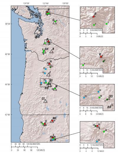
Map of hydrothermal-monitoring sites in the U.S. portion of the Cascade Range, numbered consecutively north to south.
Volcanoes (open triangles) are B, Mount Baker, G, Glacier Peak, R, Mount Rainier, A, Mount Adams, SH, Mount St. Helens, H, Mount Hood, J, Mount Jefferson, SS, South Sister, BB, Bachelor Butte, N, Newberry, CL, Crater Lake, ML, Medicine Lake, S, Shasta, and L, Mount Lassen. Red circles denote sites with continuous temperature monitoring and intermittent gas sampling. Green circles denote sites with continuous pressure-temperature-conductivity monitoring and intermittent liquid sampling and discharge measurements; black dots within green circles indicate the availability of complementary vent-temperature records. Blue circles indicate intermittent flux measurements extending over a period of several decades.
Sources/Usage
Public Domain.