
Lidar data shows changes in beach profile
By Pacific Coastal and Marine Science Center
December 2012 (approx.)

Detailed Description
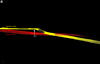
Lidar data collected December 11, 2012 (yellow), in comparison with lidar data collected October 29, 2010 (red), showing change in beach profile. Spot marked by vertical arrow was 1.08 meters higher at time of 2012 survey than at time of 2010 survey. Such measurements are possible because the points in each lidar data set have precise x, y, and z coordinates.
Sources/Usage
Public Domain.