
Modeling Tradeoffs Between Energy Development and Habitat Conservation
Detailed Description
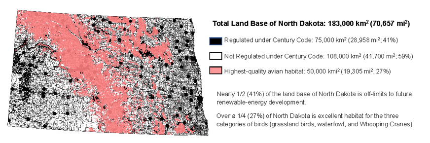
Total Land Base of North Dakota: 183,000 km2 (70,657 mi2)
Visual depiction of the amount of “Regulated” and “Not Regulated Land” in North Dakota.
- Black areas represent the State’s land base that is unavailable for future renewable-energy development based on the North Dakota Century Code.(75,000km2 / 28,958 mi2, 41%)
- White areas represent the land base theoretically available for future renewable-energy development or other societally approved land uses. (108,000 km2 / 41,700 mi2, 59%)
- Pink areas represent the highest-quality habitat for 3 categories of birds. (50,000km2 / 19,305 mi2, 27%)
This visual allows one to see where potential conflicts and tradeoffs may occur between future energy development and future avian-conservation efforts. The model predicts minimal conflict between energy development and avian-conservation efforts for an area representing about 54% of the “Not Regulated Land.”
Nearly 1/2 (41%) of the land base of North Dakota is off-limits to future renewable-energy development.
Over 1/4 (27%) of North Dakota is excellent habitat for the three categories of birds (grassland, waterfowl, and Whooping Cranes).
Sources/Usage
Public Domain.
Shaffer, J.A., Niemuth, N.D., Loesch, C.R., Derby, C.E., Pearse, A.T., Barnes, K.W., Shaffer, T.L., and Ryba, A.J., 2022, Limited land base and competing land uses force societal tradeoffs when siting energy development: Journal of Fish and Wildlife Management, v. 13, no. 1, p. 106–123; e1944-687X. https://doi.org/10.3996/JFWM-21-036.