
Monitoring Bank Erosion at Lower Brule, SD

Detailed Description
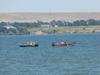
The Lower Brule Environmental Protection Office and USGS provided "chase" boats to carry unmanned aerial system (UAS) spotters during the UAS flights at Lower Brule, SD, August 21-23, 2012. This period included 1-day field demonstration for Tribes, Federal, State, and local agencies and others at Lower Brule, SD. Spotters are required to keep the unmanned aerial vehicle in direct view at all times, and they travelled the entire 7-mile stretch of shoreline during the 17 UAS flights that were conducted in the effort to monitor bank erosion on the Missouri River near Lower Brule, SD.
Sources/Usage
Public Domain.