
Monitoring Bank Erosion at Lower Brule, SD

Detailed Description
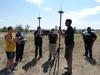
National Park Service personnel, use the Real-Time Kinematic (RTK) satellite navigation data collection handheld equipment while Ryan Thompson (USGS) explains their use, assisted by USGS students Vicki Prautzsch and Adonnis Martinez, during a 1-day field demonstration. The demonstration was hosted by the Lower Brule Environmental Protection Office and USGS for Tribes, Federal, State, and local agencies and others on August 23, 2012, at Lower Brule, SD. RTK global positioning satellite equipment is being used to establish precise shoreline location during a study of shoreline erosion along the Missouri River.
Sources/Usage
Public Domain.