
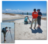
Scientists collect data on Pelican Island, Alabama
By St. Petersburg Coastal and Marine Science Center
2018 (approx.)

Detailed Description
In an effort spanning the Natural Hazards and Ecosystems Mission Areas, pilots from the Saint Petersburg and Woods Hole Coastal and Marine Science Centers collect imagery data using Unmanned Aerial System (UAS) while personnel from the Wetlands and Aquatic Research Center (WARC) conduct ground-based site surveys of Pelican Island, Alabama. These data are being combined to improve techniques in acquiring elevation and vegetation characteristics from UAS and, ultimately, to develop predictive models of how coastal change may impact shorebird use of barrier island habitat.
Sources/Usage
Public Domain.