
Sea-Floor Mapping: 2022 by the numbers

Detailed Description
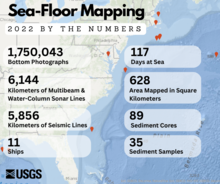
The year of 2022 was big for the Sea-Floor Mapping Group at the Woods Hole Coastal and Marine Science Center! These data were collected as part of a collaborative research program and include data collected by USGS and our partners. As the map shows, sea floor mapping was conducted in the Gulf of Mexico, Chesapeake Bay, Stellwagen Bank National Marine Sanctuary, Nantucket Sound, and other locations in the Atlantic Ocean.
Sources/Usage
Public Domain.