
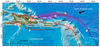
Topography and bathymetry map of the Northeastern Caribbean.

Detailed Description
Map of the Northeastern Caribbean: topography is in shades of green and bathymetry in shades of blue. Fault traces are shown as lines with the following descriptions: barbed=thrust fault; solid=strike-slip fault with arrows showing relative direction of motion; black and white=normal fault. Faults outlined in red have a potential to generate a large earthquake. The arrow at the top right corner shows the direction of the North American plate motion relative to the Caribbean plate. All red stars with a date before the 20th century show the intensity center (MI) for that earthquake. The red star with a red ellipse shows the general location of several 17th century earthquakes with sparse felt data. Stars with 20th and 21st century years are earthquake epicenters located using instrument data. Years in boxes next to red outlines are reoccurrence rates. Red question marks indicate unknown reoccurrence rates for those respective faults. Those parts of the subduction zone not outlined by red are not expected from this study to generate large earthquakes
Sources/Usage
Public Domain.