
USGS Ocean Science


Detailed Description
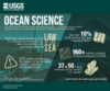
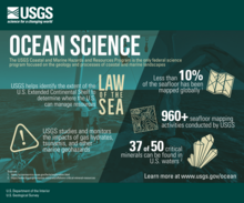
USGS Ocean Science
The USGS Coastal and Marine Hazards and Resources Program is the only federal science program focused on the geology and processes of coastal and marine landscapes.
- USGS helps identify the extent of the U.S. Extended Continental Shelf to determine where the U.S. can manage resources (Law of the Sea)
- USGS studies and monitors the impacts of gas hydrates, tsunamis, and other marine geohazards
- Less than 10% of the seafloor has been mapped globally 1
- 960+ seafloor mapping activities conducted by USGS
- 47 of 50 critical minerals can be found in U.S. waters 2
Sources:
1. https://oceanservice.noaa.gov/facts/exploration.html
2. https://www.boem.gov/marine-minerals/offshore-critical-mineral-resources
Learn more at www.usgs.gov/ocean.
U.S. Department of the Interior
U.S. Geological Survey
Sources/Usage
Public Domain.