
What caused—or did not cause—the 2018 Kīlauea eruption?

Detailed Description
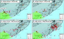
Earthquakes (red dots) track the progression of the magmatic intrusion from Kīlauea Volcano's middle East Rift Zone to the lower East Rift Zone between April 30 and May 3, 2018. Orange triangles show the locations of fissure 1 (right), which erupted on May 3, and Pu‘u ‘Ō‘ō (left). The earthquakes shown here are well-located with magnitudes less than 3.5 and depths shallower than 7 km (4.3 miles). USGS graphic.
Sources/Usage
Public Domain.