
Before and After: Coastal Change Caused by Hurricane Michael
To learn more about USGS’ role providing science to decision makers before, during and after Hurricane Michael, visit the USGS Hurricane Michael page at https://usgs.gov/hurricane-michael.

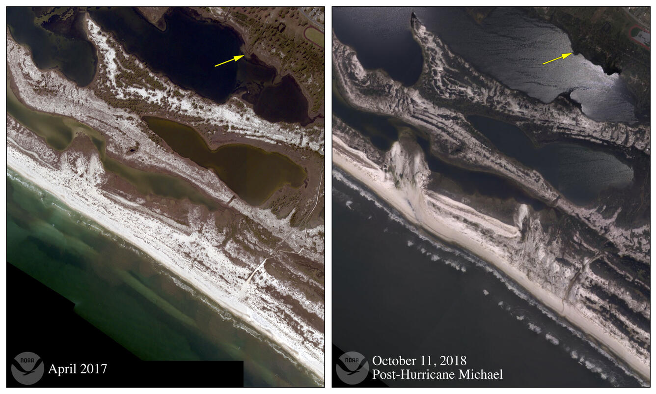
The USGS Coastal Change Hazards Storm team is working on a detailed assessment of Hurricane Michael’s effects on Florida’s vulnerable shorelines. The team is currently comparing low-altitude, high angle oblique aerial photos taken by the National Oceanic and Atmospheric Administration in 2017 to similar NOAA photos collected a day after Hurricane Michael made landfall. The USGS scientists are analyzing the photos, which document the hurricane’s impact on the coast, to fine-tune coastal change forecasting models.
“High altitude satellite images give us a big picture view of the coastline, and that’s very useful to identify large areas of overwash, but we can’t see the dunes in those images,” said Kara Doran, the Coastal Change Hazards team leader. “These lower-altitude oblique photos give us a clearer view of the beach and dunes. We can see whether the storm surge and waves altered or eliminated that protective barrier, and what happened to the houses and roads behind the dunes.”
These oblique photos are also extremely useful to USGS researchers because the images are normally taken shortly after a storm has passed, capturing the immediate post-storm conditions of the beaches. This allows the Coastal Change Hazards team to compare their pre-storm coastal change forecast to the post-storm aftermath, assess the coastal change forecast’s accuracy and use that data in future coastal change models.
“So far, our preliminary analysis indicates our coastal change forecasts performed fairly well in terms of predicating what areas would be affected by overwash, or areas where surge overtopped the dunes,” Doran said. “Along the Florida panhandle, our forecast predicted a high likelihood of overwash from St. Andrews State Park to Mexico Beach, and the dunes in those areas do appear to have undergone overwash.”

One area that saw significant coastal change that was not predicted by the Hurricane Michael Coastal Change Forecast was on T.H. Stone Memorial St. Joseph Peninsula State Park. Michael’s rough waves and surge carved a new breach into the peninsula, washing out the road and turning part of the park into an island.
“Our models don’t take into account the duration of elevated water levels, so when the water levels are above normal days before a storm, those dunes are already eroding before they see the peak impacts from a storm,” said Doran. “That’s an area of interest we are looking into for future research.”
The USGS Total Water Level and Coastal Change Forecast Viewer does provide forecasts of the timing, duration, and magnitude of water levels at the coast, but it is not yet available for most of the Gulf of Mexico. The USGS plans to expand the model into the Gulf in 2019.
When a storm is about to strike the U.S. Atlantic or Gulf coast, the team forecasts the likelihood of coastal erosion and other changes, using a computer model that incorporates the National Hurricane Center’s storm surge predictions and National Oceanic and Atmospheric Administration wave forecasts. The USGS model adds information about the beach slope and dune height to predict how high waves and surge will move up the beach. The model forecasts three types of storm impact to the dunes that protect coastal communities: erosion, overwash, and inundation, or flooding that reaches over and behind the dunes.
The U.S. Army Corps of Engineers, in collaboration with the USGS, is planning to conduct a series of data collection flights along the Florida panhandle coast using airborne lidar, a technology that bounces beams of laser light at the ground to produce detailed elevation information about the surface below. Using that information, the USGS researchers can estimate the volume of sand that Hurricane Michael moved off Florida beaches, measure the height and breadth of the remaining dunes, and be ready to forecast the erosion potential of the next storm.
To learn more about the USGS coastal change hazard team's hurricane research at http://coastal.er.usgs.gov/hurricanes/


Get Our News
These items are in the RSS feed format (Really Simple Syndication) based on categories such as topics, locations, and more. You can install and RSS reader browser extension, software, or use a third-party service to receive immediate news updates depending on the feed that you have added. If you click the feed links below, they may look strange because they are simply XML code. An RSS reader can easily read this code and push out a notification to you when something new is posted to our site.