
Seismic Research Cruise Provides New Data on U.S. Atlantic Margin
Data Describe Gas Hydrate Deposits, Submarine Landslide Deposits & Shallow Faults
Data acquired by the U.S. Geological Survey on the U.S. Atlantic Margin in August 2018 reveal new information about the distribution of gas hydrates in the sector stretching from the upper continental slope to deep water areas offshore New Jersey to North Carolina.
Data acquired by the U.S. Geological Survey on the U.S. Atlantic Margin in August 2018 reveal new information about the distribution of gas hydrates in the sector stretching from the upper continental slope to deep water areas offshore New Jersey to North Carolina. The Mid-Atlantic Resource Imaging Experiment (MATRIX), which was jointly sponsored by the USGS Coastal/Marine Hazards and Resources Program (CMHRP), the Methane Hydrates R&D Program at the Department of Energy, and the Bureau of Ocean Energy Management, acquired more than 2,000 kilometers (about 1,240 statute miles) of marine seismic data that image gas hydrate features and other geologic structures below the seafloor.
Gas hydrate forms naturally in seafloor sediments when methane and water combine at moderate pressures and relatively low temperatures. Gas hydrate deposits resemble ice, and they concentrate enormous amounts of methane in the global oceans and in permafrost areas. On the U.S. Atlantic Margin, BOEM had previously identified potential deep water gas hydrate accumulations that guided planning for MATRIX. In fact, the sediments of deep marine continental margins host nearly 99 percent of the world’s gas hydrate.
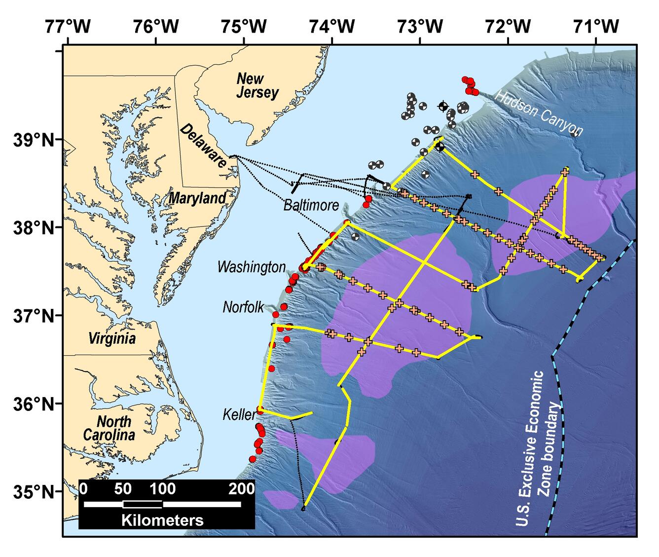
The MATRIX data capture images 1 to 3 km (about 3,300 to 9,800 ft) below the seafloor and provide new information about the distribution of a key seismic indicator linked to the presence of gas hydrate. The data also reveal shallow gas deposits and structural features beneath some of the hundreds of seafloor methane seeps discovered along the Atlantic Margin since 2011. Images include submarine landslide deposits, shallow faults, and sedimentary markers considered important in interpreting the history of the Atlantic Ocean basin to inform assessment of geologic hazards along the eastern seaboard.
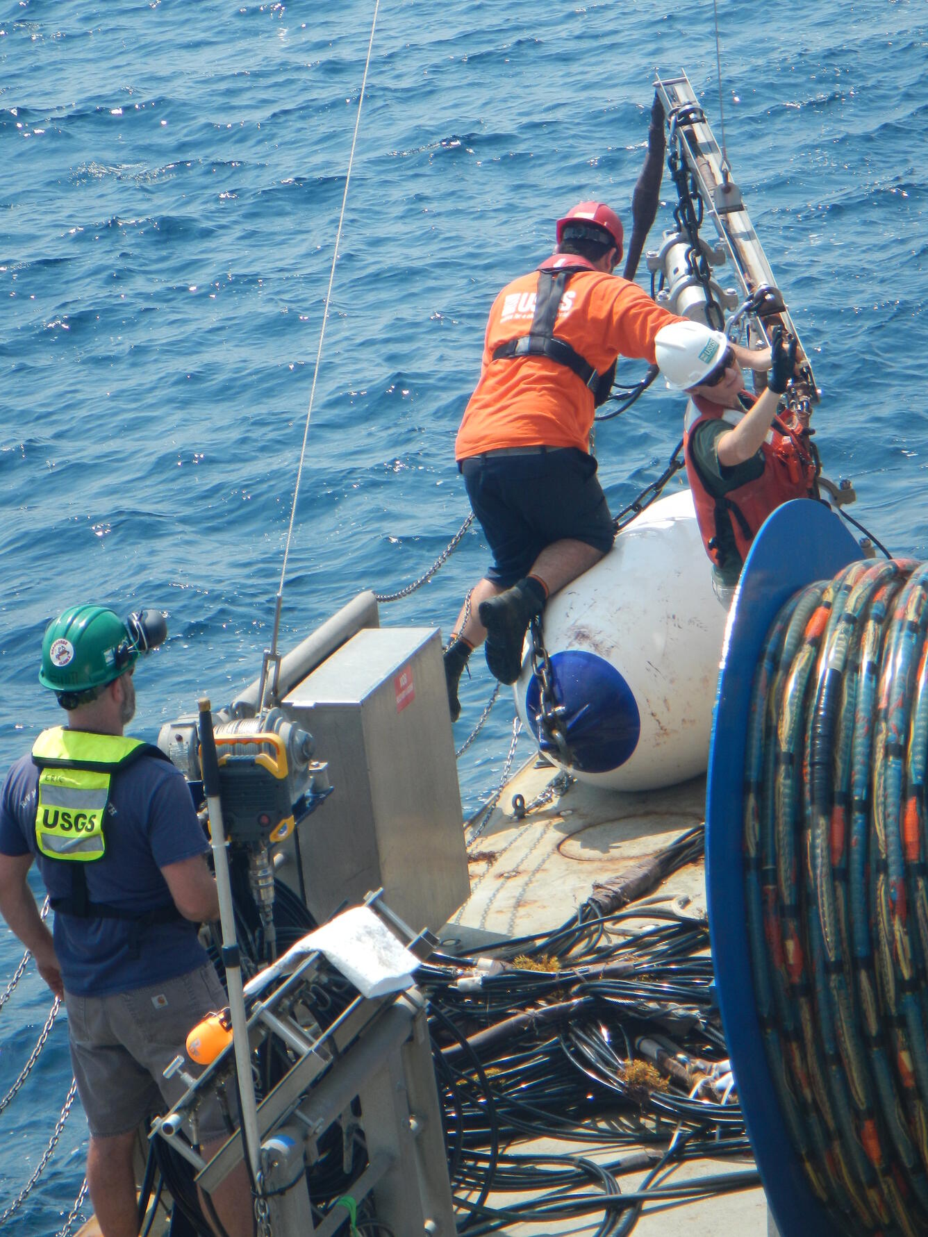
During MATRIX, USGS scientists and operational staff from CMHRP were joined by BOEM scientists, protected species visual observers, and outside technicians aboard the research vessel (R/V) Hugh R. Sharp, which is owned and operated by the University of Delaware as part of the University-National Oceanographic Laboratory System.
Up to four airguns were used to generate the acoustic energy for imaging seafloor sediments. The seismic signals were recorded by 112 to 160 receivers towed behind the ship and arrayed within a streamer up to 1.2 kilometers (0.75 miles) long. The USGS also deployed 60 sonobuoys, which are expendable instruments that receive seismic signals and transmit the information back to the ship at distances up to 15 km (9.3 miles).
Renee Orr, Chief of BOEM's Office of Strategic Resources commented, “MATRIX presented an opportunity to acquire modern seismic data to refine understanding of gas hydrates on the U.S. Atlantic margin in areas that both BOEM and the USGS have previously identified as worthy of study.”
Lou Capitanio, program manager for DOE’s Methane Hydrates program, added that, “MATRIX also represented an important step in addressing interagency priorities to identify deep water gas hydrate deposits on U.S. marine margins.”
MATRIX Chief Scientists Carolyn Ruppel and Nathan Miller, both marine geophysicists with the USGS, credited excellent weather and a favorable Gulf Stream current as key factors in the success of the seismic cruise. Researchers acquired six seismic lines running down the continental slope from the shelf-break to waters as deep as 4,000 meters (about 13,100 ft) offshore New Jersey, Delaware, Maryland, Virginia, and North Carolina. MATRIX also completed three upper continental slope lines and three deep water (more than 2,700 meters water depth) lines oriented parallel to the coastline in this sector.
John Haines, Program Coordinator for USGS CMHRP, noted that the MATRIX effort “engaged scientific, technical, and operations staff across our USGS program and marked the first time since the 1990s that CMHRP has independently conducted a regional-scale seismic project with airgun sources. The multiagency collaboration that contributed to the success of MATRIX is an excellent model for marine seismic programs that support mission-related research objectives.”

In addition to the scientific partnership among the USGS Gas Hydrates Project, DOE, and BOEM, MATRIX benefited from logistical support provided by Scripps Institute of Oceanography, Lamont-Doherty Earth Observatory, and the National Science Foundation. The National Marine Fisheries Service of the National Oceanic and Atmospheric Administration supported environmental compliance and permitting under the Marine Mammal Protection Act and the Endangered Species Act.
The USGS Gas Hydrates Project focuses on the energy resource potential of gas hydrates, the interaction between hydrates and the environment, and connections between gas hydrates and geohazards like submarine landslides. MATRIX produced data that will, for years to come, facilitate studies in all of these areas and support broader analyses of the margin’s hazards, stratigraphy, and deep structure by the USGS, other agencies, and the academic community.
Read DOE-National Energy Technology Laboratory's announcement here.
Get Our News
These items are in the RSS feed format (Really Simple Syndication) based on categories such as topics, locations, and more. You can install and RSS reader browser extension, software, or use a third-party service to receive immediate news updates depending on the feed that you have added. If you click the feed links below, they may look strange because they are simply XML code. An RSS reader can easily read this code and push out a notification to you when something new is posted to our site.