
This thermal timelapse (from F1cam webcam) shows the switch from water lake to lava lake in Halema‘uma‘u, spanning December 20 to December 24. During the initial phase of lava appearing in the crater, a large steam plume is generated as lava interacts with and boils off the water lake.
Quantifying hazards from magma-water interaction at the summit of Kīlauea
By Kīlauea
Project Investigator Ryan Cahalan aims to quantify the potential hazards of magma-water interaction at the summit of Kīlauea and answer some key questions: (1) What is the rate of water entrainment into submerged volcanic jets? (2) What factors in wet volcanic jetting control the distance travelled by base surges and ballistics?
Experiments are being conducted at Washington State University Vancouver with Steve Solovitz to quantify water ingestion rates in eruption jets. We will answer the second question using a numerical model of underwater explosive eruptions that Ryan Cahalan developed during his PhD. The model will be updated from 2D to 3D and have conditions adjusted to simulate shallow-water environments. The experimental results will be used to validate the eruption model. The final goal was to develop a hazard map for eruptions through the water lake based on simulation results. This would aid to mitigate hazards if an eruption were to appear imminent.
The 2D subaqueous eruption model was improved by implementing in 3D, incorporating a Kīlauea digital elevation model into the 3D code, and testing out an air-water free surface condition for increased model accuracy. Each of these milestones were completed and are ready for further testing. In the December 20, 2021 Kīlauea summit eruption lava entered the water lake and boiled away the 50 m (164 ft) deep lake in 90-minutes. This produced a short lived, but tall (13,000 m, or about 43,000 ft, high) steam-rich plume in an otherwise docile eruption. While the immediate threat of hydrovolcanism vanished with the water lake, the eruption provided a uniquely well-constrained dataset. We have analyzed weather radar, infrasound and seismic data, camera footage, and field and satellite observations to constrain eruption timing, plume height time series, and plume rise rates. We introduced a method for measuring plume height using astrometry (star mapping). We examined the plume structure with 3D radar visualizations and found strong reflectivity zones coinciding indicative of the presence of large particles (possibly ashy raindrops or hail) that were transported downwind and deposited beyond sampled areas. The radar visualizations show an ice-dominated upper plume collocated with lightning flashes. With no ash detection from satellite, this suggests that ice charging is responsible for generating the lightning flashes. We utilized plume height measurements with 1D plume modeling to derive lake boiling rates to compare to lava-water interaction heat transfer models.
A manuscript is in preparation on the analysis of the 2020 Kīlauea eruption. This work was presented to the Volcano Science Center in June, in an HVO Volcano Watch in July, and will be presented at the American Geophysical Union Fall Meeting in 2021.
Related Content
")
Halema'uma'u — Switch from Water Lake to Lava Lake (Thermal)
This thermal timelapse (from F1cam webcam) shows the switch from water lake to lava lake in Halema‘uma‘u, spanning December 20 to December 24. During the initial phase of lava appearing in the crater, a large steam plume is generated as lava interacts with and boils off the water lake.
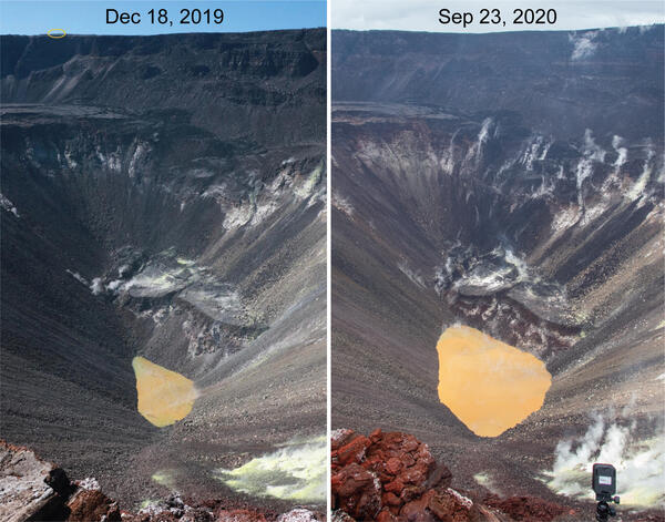
Kīlauea's summit water lake comparison - September 23, 2020
HVO geologists made observations of Kīlauea's summit water lake from the east rim of Halema‘uma‘u. This view point is on the large downdropped block that subsided during the 2018 collapse events. From this spot, a view of the entire lake is possible, providing a new perspective on the growth of the lake.
HVO geologists made observations of Kīlauea's summit water lake from the east rim of Halema‘uma‘u. This view point is on the large downdropped block that subsided during the 2018 collapse events. From this spot, a view of the entire lake is possible, providing a new perspective on the growth of the lake.

Color variations at Kīlauea's summit water lake - 09/18/2020
Color variations are common at Kīlauea's summit water lake, and are usually dominated by tan and brown hues. Today, the interaction between different color zones produced a large swirl in the center of the lake.
Color variations are common at Kīlauea's summit water lake, and are usually dominated by tan and brown hues. Today, the interaction between different color zones produced a large swirl in the center of the lake.
Kīlauea Volcano summit water lake ripples and steaming on September 18
This video shows a close-up of the northern shoreline of the water lake at the summit of Kīlauea Volcano. Steaming and subtle ripples are present on the water surface. Zooming out gives a sense of the scale of the lake. The lake level is approximately 576 meters (1890 ft) below the camera. USGS video by M. Patrick.
This video shows a close-up of the northern shoreline of the water lake at the summit of Kīlauea Volcano. Steaming and subtle ripples are present on the water surface. Zooming out gives a sense of the scale of the lake. The lake level is approximately 576 meters (1890 ft) below the camera. USGS video by M. Patrick.

Timelapse: 45 minutes of activity at Kīlauea's summit water lake
This timelapse video shows approximately 45 minutes of activity in the water lake at the summit of Kīlauea volcano. The video shows that the color zones are highly dynamic, shifting from minute to minute. This behavior has been common in the lake during much of the past year. Note that the camera exposure changes several times, shifting the color slightly at times.
This timelapse video shows approximately 45 minutes of activity in the water lake at the summit of Kīlauea volcano. The video shows that the color zones are highly dynamic, shifting from minute to minute. This behavior has been common in the lake during much of the past year. Note that the camera exposure changes several times, shifting the color slightly at times.

Kīlauea Volcano's summit water lake is one-year old
Plot showing rise of Kīlauea's summit crater lake over the past year, during which laser rangefinder measurements of lake level were made 2–3 times per week. Photos compare the lake on August 27, 2019, when it was ~22 ft (7 m) deep, to July 7, 2020, when it was ~130 ft (40 m) deep. USGS photos.
Plot showing rise of Kīlauea's summit crater lake over the past year, during which laser rangefinder measurements of lake level were made 2–3 times per week. Photos compare the lake on August 27, 2019, when it was ~22 ft (7 m) deep, to July 7, 2020, when it was ~130 ft (40 m) deep. USGS photos.

Comparison of images showing growth of Kīlauea's summit water lake
Comparison of images showing growth of Kīlauea's summit water lake over the past year. The left image, taken on August 2, 2019, shows a small green pond that was approximately 6 ft (2 m) deep. The right image, taken on July 21, 2020, shows a lake more than 130 ft (40 m) deep with shades of tan to brown and a sharp color boundary often cutting across the lake.
Comparison of images showing growth of Kīlauea's summit water lake over the past year. The left image, taken on August 2, 2019, shows a small green pond that was approximately 6 ft (2 m) deep. The right image, taken on July 21, 2020, shows a lake more than 130 ft (40 m) deep with shades of tan to brown and a sharp color boundary often cutting across the lake.

Thermal video of Kīlauea's summit water lake on June 23, 2020
This thermal video shows typical activity at Kīlauea's summit water lake. Steam carried across the water surface often masks thermal features on the underlying water surface. USGS video by M. Patrick.
This thermal video shows typical activity at Kīlauea's summit water lake. Steam carried across the water surface often masks thermal features on the underlying water surface. USGS video by M. Patrick.

Kīlauea summit water lake KW webcam images 11-1-2019 to 10-30-2020
ANIMATED GIF: The KWcam webcam has been imaging the Kīlauea summit water lake for just over a year now, tracking visual changes in the lake including water level and color.
ANIMATED GIF: The KWcam webcam has been imaging the Kīlauea summit water lake for just over a year now, tracking visual changes in the lake including water level and color.
Related Content
Halema'uma'u — Switch from Water Lake to Lava Lake (Thermal)
This thermal timelapse (from F1cam webcam) shows the switch from water lake to lava lake in Halema‘uma‘u, spanning December 20 to December 24. During the initial phase of lava appearing in the crater, a large steam plume is generated as lava interacts with and boils off the water lake.
This thermal timelapse (from F1cam webcam) shows the switch from water lake to lava lake in Halema‘uma‘u, spanning December 20 to December 24. During the initial phase of lava appearing in the crater, a large steam plume is generated as lava interacts with and boils off the water lake.
Kīlauea's summit water lake comparison - September 23, 2020
HVO geologists made observations of Kīlauea's summit water lake from the east rim of Halema‘uma‘u. This view point is on the large downdropped block that subsided during the 2018 collapse events. From this spot, a view of the entire lake is possible, providing a new perspective on the growth of the lake.
HVO geologists made observations of Kīlauea's summit water lake from the east rim of Halema‘uma‘u. This view point is on the large downdropped block that subsided during the 2018 collapse events. From this spot, a view of the entire lake is possible, providing a new perspective on the growth of the lake.
Color variations at Kīlauea's summit water lake - 09/18/2020
Color variations are common at Kīlauea's summit water lake, and are usually dominated by tan and brown hues. Today, the interaction between different color zones produced a large swirl in the center of the lake.
Color variations are common at Kīlauea's summit water lake, and are usually dominated by tan and brown hues. Today, the interaction between different color zones produced a large swirl in the center of the lake.
Kīlauea Volcano summit water lake ripples and steaming on September 18
This video shows a close-up of the northern shoreline of the water lake at the summit of Kīlauea Volcano. Steaming and subtle ripples are present on the water surface. Zooming out gives a sense of the scale of the lake. The lake level is approximately 576 meters (1890 ft) below the camera. USGS video by M. Patrick.
This video shows a close-up of the northern shoreline of the water lake at the summit of Kīlauea Volcano. Steaming and subtle ripples are present on the water surface. Zooming out gives a sense of the scale of the lake. The lake level is approximately 576 meters (1890 ft) below the camera. USGS video by M. Patrick.
Timelapse: 45 minutes of activity at Kīlauea's summit water lake
This timelapse video shows approximately 45 minutes of activity in the water lake at the summit of Kīlauea volcano. The video shows that the color zones are highly dynamic, shifting from minute to minute. This behavior has been common in the lake during much of the past year. Note that the camera exposure changes several times, shifting the color slightly at times.
This timelapse video shows approximately 45 minutes of activity in the water lake at the summit of Kīlauea volcano. The video shows that the color zones are highly dynamic, shifting from minute to minute. This behavior has been common in the lake during much of the past year. Note that the camera exposure changes several times, shifting the color slightly at times.
Kīlauea Volcano's summit water lake is one-year old
Plot showing rise of Kīlauea's summit crater lake over the past year, during which laser rangefinder measurements of lake level were made 2–3 times per week. Photos compare the lake on August 27, 2019, when it was ~22 ft (7 m) deep, to July 7, 2020, when it was ~130 ft (40 m) deep. USGS photos.
Plot showing rise of Kīlauea's summit crater lake over the past year, during which laser rangefinder measurements of lake level were made 2–3 times per week. Photos compare the lake on August 27, 2019, when it was ~22 ft (7 m) deep, to July 7, 2020, when it was ~130 ft (40 m) deep. USGS photos.
Comparison of images showing growth of Kīlauea's summit water lake
Comparison of images showing growth of Kīlauea's summit water lake over the past year. The left image, taken on August 2, 2019, shows a small green pond that was approximately 6 ft (2 m) deep. The right image, taken on July 21, 2020, shows a lake more than 130 ft (40 m) deep with shades of tan to brown and a sharp color boundary often cutting across the lake.
Comparison of images showing growth of Kīlauea's summit water lake over the past year. The left image, taken on August 2, 2019, shows a small green pond that was approximately 6 ft (2 m) deep. The right image, taken on July 21, 2020, shows a lake more than 130 ft (40 m) deep with shades of tan to brown and a sharp color boundary often cutting across the lake.
Thermal video of Kīlauea's summit water lake on June 23, 2020
This thermal video shows typical activity at Kīlauea's summit water lake. Steam carried across the water surface often masks thermal features on the underlying water surface. USGS video by M. Patrick.
This thermal video shows typical activity at Kīlauea's summit water lake. Steam carried across the water surface often masks thermal features on the underlying water surface. USGS video by M. Patrick.
Kīlauea summit water lake KW webcam images 11-1-2019 to 10-30-2020
ANIMATED GIF: The KWcam webcam has been imaging the Kīlauea summit water lake for just over a year now, tracking visual changes in the lake including water level and color.
ANIMATED GIF: The KWcam webcam has been imaging the Kīlauea summit water lake for just over a year now, tracking visual changes in the lake including water level and color.