
Laramide Basin Evolution Completed
The Southern Rocky Mountains include Proterozoic-basement-cored uplifts and flanking sedimentary basins that formed during the protracted Laramide orogeny that began in the Late Cretaceous and ended during the Eocene. Basin-fill sequences reveal important information on the timing and character of these basement-cored uplifts as well as the overall dynamics of the Laramide orogeny.

A Task of the Cenozoic Landscape Evolution of the Southern Rocky Mountains Project.
Recent detailed work in the Denver Basin indicates that Late Cretaceous to earliest Eocene synorogenic sediments record early pulses of surface uplift. Significant lacunae and paleosols denote times of relative stability, climate change, and/or deep weathering. Less detailed work in the South Park and Raton Basins has indicated similar timing and style of uplift and more continuous synorogenic deposition than in the Denver Basin. Deposits in the North Park and Middle Park Basin consist of volcaniclastic and arkosic fluvial, deltaic, and lacustrine strata (Paleocene Middle Park Formation, and Paleocene and Eocene Coalmont Formation; >8,000 ft thick), and also record exposure and erosion of Proterozoic-basement-cored uplifts, but with a unique timing, sequence, and geometry.
Late Cretaceous marine shale was buried by early synorogenic sediments in the Denver Basin east of the Front Range, while correlative marine shale was being eroded from the areas west of the Front Range. Erosion of Proterozoic basement and deposition of synorogenic sediments west of the Front Range occurred during a prolonged gap in deposition to the east. Similarly, the Hanna Basin in Wyoming contains a very thick sequence of synorogenic sediments (Paleocene Hanna Formation; >13,500 ft thick) that represents the creation of considerable accommodation space when other areas of the Laramide foreland were relatively quiescent. Other Laramide basins in the southern Rocky Mountain region encompass a wide array of timing, geometry, and sedimentology. Most basins contain multiple unconformities, some including the Paleocene to Eocene boundary, that likely represent tectonic and/or climatic variations. Deformation occurred before, during, and after deposition along north- to northwest-trending structures. Surrounding basement-cored ranges may not have risen uniformly or even at all during Laramide deposition. Therefore, the sedimentary record in each basin can give unique information about local tectonic and regional climatic events across the Laramide foreland. Episodes of erosion and relative stability mark the late Eocene to early Oligocene transition signaling the end of the Laramide Orogeny. Deposits of this age (e.g., White River Formation of northern Colorado and Wyoming) record low-energy depositional environments reflecting a prolonged period of low topographic relief and no significant uplift.
After eruption of large-scale volcanic systems and initiation of wide-spread extensional faulting and regional uplift during the late Oligocene through Miocene across the Southern Rocky Mountains, deposition of coarse clastic synorogenic alluvial and locally eolian sediments (Santa Fe, Dry Union, North Park, and Browns Park Formations) began within localized structural grabens, half-grabens, and valleys reflecting dynamic changes in topography, elevation, and paleogeography. As these structural basins evolved over time chiefly in response to changing tectonic rates and loci, a thick, mostly alluvial apron was deposited in a broad wedge extending eastward over the plains for hundreds of miles. In areas where substantial faulting has continued into the Quaternary, fault-bounded basins have continued to accumulate sediments, whereas, regional uplift has stranded other basins high on mountain blocks where they no longer accumulate sediment.

Objectives
The primary objectives of this task will be to improve knowledge on the timing, geometry, and structural controls of surface uplift, sedimentation, and synorogenic basin evolution during the Cenozoic across the Southern Rocky Mountains. Initial focus will be on the Paleocene to Eocene and Oligocene to Miocene within the North Park and Middle Park Basins and surrounding areas. Comparison of the timing, style, and magnitude of events recorded in this area with that of other basins and uplifts in the southern Rocky Mountains will allow for a regional scale assessment and revision of current tectonic models of basin evolution. Comparison of new details of the sedimentary record west of the Front Range, for example, with that of the previously studied Denver Basin east of the Front Range during the Late Cretaceous through Paleocene will place limits on the wavelength and geometry of the Laramide Front Range uplift. New or revised paradigms will be tested across other basins and refined accordingly.
These comparative studies will facilitate:
- Evaluation of contrasting structural models
- Revision of regional tectonic and stress field models
- Interpretation of local and regional paleogeography
- Better understanding of Cenozoic climate variations and surface paleoelevations and their impacts on sedimentary processes and paleobotany
- Modeling of geometry and potential impacts on fragile alluvial aquifers within high mountain parks and valleys
- New constraints on hydrocarbon thermal evolution and trap geometry within the important active oil- and gas-producing basins of the region


- Overview
The Southern Rocky Mountains include Proterozoic-basement-cored uplifts and flanking sedimentary basins that formed during the protracted Laramide orogeny that began in the Late Cretaceous and ended during the Eocene. Basin-fill sequences reveal important information on the timing and character of these basement-cored uplifts as well as the overall dynamics of the Laramide orogeny.
Sources/Usage: Some content may have restrictions. View Media DetailsPhysiographic map view of primary project area showing North Park, Middle Park, and Laramie River valley basins with surrounding mountain ranges (Base from NED data) A Task of the Cenozoic Landscape Evolution of the Southern Rocky Mountains Project.
Recent detailed work in the Denver Basin indicates that Late Cretaceous to earliest Eocene synorogenic sediments record early pulses of surface uplift. Significant lacunae and paleosols denote times of relative stability, climate change, and/or deep weathering. Less detailed work in the South Park and Raton Basins has indicated similar timing and style of uplift and more continuous synorogenic deposition than in the Denver Basin. Deposits in the North Park and Middle Park Basin consist of volcaniclastic and arkosic fluvial, deltaic, and lacustrine strata (Paleocene Middle Park Formation, and Paleocene and Eocene Coalmont Formation; >8,000 ft thick), and also record exposure and erosion of Proterozoic-basement-cored uplifts, but with a unique timing, sequence, and geometry.
Late Cretaceous marine shale was buried by early synorogenic sediments in the Denver Basin east of the Front Range, while correlative marine shale was being eroded from the areas west of the Front Range. Erosion of Proterozoic basement and deposition of synorogenic sediments west of the Front Range occurred during a prolonged gap in deposition to the east. Similarly, the Hanna Basin in Wyoming contains a very thick sequence of synorogenic sediments (Paleocene Hanna Formation; >13,500 ft thick) that represents the creation of considerable accommodation space when other areas of the Laramide foreland were relatively quiescent. Other Laramide basins in the southern Rocky Mountain region encompass a wide array of timing, geometry, and sedimentology. Most basins contain multiple unconformities, some including the Paleocene to Eocene boundary, that likely represent tectonic and/or climatic variations. Deformation occurred before, during, and after deposition along north- to northwest-trending structures. Surrounding basement-cored ranges may not have risen uniformly or even at all during Laramide deposition. Therefore, the sedimentary record in each basin can give unique information about local tectonic and regional climatic events across the Laramide foreland. Episodes of erosion and relative stability mark the late Eocene to early Oligocene transition signaling the end of the Laramide Orogeny. Deposits of this age (e.g., White River Formation of northern Colorado and Wyoming) record low-energy depositional environments reflecting a prolonged period of low topographic relief and no significant uplift.
After eruption of large-scale volcanic systems and initiation of wide-spread extensional faulting and regional uplift during the late Oligocene through Miocene across the Southern Rocky Mountains, deposition of coarse clastic synorogenic alluvial and locally eolian sediments (Santa Fe, Dry Union, North Park, and Browns Park Formations) began within localized structural grabens, half-grabens, and valleys reflecting dynamic changes in topography, elevation, and paleogeography. As these structural basins evolved over time chiefly in response to changing tectonic rates and loci, a thick, mostly alluvial apron was deposited in a broad wedge extending eastward over the plains for hundreds of miles. In areas where substantial faulting has continued into the Quaternary, fault-bounded basins have continued to accumulate sediments, whereas, regional uplift has stranded other basins high on mountain blocks where they no longer accumulate sediment.
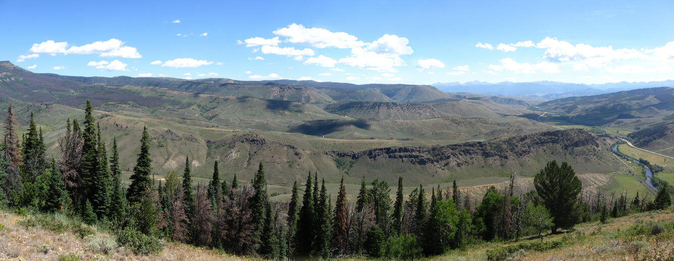
Sources/Usage: Some content may have restrictions. View Media DetailsMt. Bross: Photomosaic view over the southern Colorado Headwaters Basin (CHB) from the west flank of the Breccia Spoon syncline. Brownish, rugged ridge in the middle ground (just above the foreground trees) is the Windy Gap Volcanic Member deposited on the eroded Pierre Shale. Stair-step topography in the distance reflects sedimentary architecture of the Middle Park Formation marked by interbedded fluvial sandstone-siltstone sequences capped by persistent conglomerate zones. Colorado River at lower right flows toward the viewpoint at Mount Bross, just north of Hot Sulphur Springs. (Credit: J. Trexler, USGS. Public domain.)
Sources/Usage: Some content may have restrictions. View Media DetailsSimplified geologic map of project area. (From Tweto, 1979) Objectives
The primary objectives of this task will be to improve knowledge on the timing, geometry, and structural controls of surface uplift, sedimentation, and synorogenic basin evolution during the Cenozoic across the Southern Rocky Mountains. Initial focus will be on the Paleocene to Eocene and Oligocene to Miocene within the North Park and Middle Park Basins and surrounding areas. Comparison of the timing, style, and magnitude of events recorded in this area with that of other basins and uplifts in the southern Rocky Mountains will allow for a regional scale assessment and revision of current tectonic models of basin evolution. Comparison of new details of the sedimentary record west of the Front Range, for example, with that of the previously studied Denver Basin east of the Front Range during the Late Cretaceous through Paleocene will place limits on the wavelength and geometry of the Laramide Front Range uplift. New or revised paradigms will be tested across other basins and refined accordingly.
These comparative studies will facilitate:
- Evaluation of contrasting structural models
- Revision of regional tectonic and stress field models
- Interpretation of local and regional paleogeography
- Better understanding of Cenozoic climate variations and surface paleoelevations and their impacts on sedimentary processes and paleobotany
- Modeling of geometry and potential impacts on fragile alluvial aquifers within high mountain parks and valleys
- New constraints on hydrocarbon thermal evolution and trap geometry within the important active oil- and gas-producing basins of the region
Sources/Usage: Some content may have restrictions. View Media DetailsGeneralized composite stratigraphic section of exposed rocks in the North and Middle Park basins compiled by project member Marieke Dechesne based upon measured sections and drill logs throughout the study area.
Sources/Usage: Some content may have restrictions. View Media DetailsTiming of deposition of Laramide strata in the Colorado Headwaters Basin vs. Denver Basin: Comparison of generalized Upper Cretaceous to Eocene stratigraphy between North Park/Middle Park basin west of the Laramide Front Range uplift and Denver basin to east of uplift showing geochronologic control from dated volcanic rocks, palynology data, and ammonite fossils. (From Dechesne and others, 2013)
Sources/Usage: Some content may have restrictions. View Media DetailsCorrelations of sandy units of the Upper Cretaceous Pierre Shale within, and east and west of the Kremmling (Middle Park) area showing degree of incision and subsequent deposition during Laramide basin evolution. (Figure modified from Izett and others, 1971)
Sources/Usage: Some content may have restrictions. View Media DetailsTypical andesitic volcanic clasts in the Windy Gap Volcanic Member at the base of the Paleocene Middle Park Formation. The youngest clast collected from this unit produced an Ar-Ar age of 60.5 Ma (Cole and others, 2010). (Credit: Marieke Dechesne, USGS. Public domain.)
Sources/Usage: Some content may have restrictions. View Media DetailsGeologist Ralph Shroba examines coarse gravel deposits of the Miocene North Park Formation that contain distinctive clasts of rhyolite derived from the late Oligocene Braddock Peak and/or Rabbit Ears volcanic centers. (Credit: Marieke Dechesne, USGS. Public domain.)
Sources/Usage: Some content may have restrictions. View Media DetailsLarge-scale cross-beds in the Paleogene Coalmont Formation southwest of Walden, Colorado, formed as a delta complex within a persistent lake. Sediments were chiefly eroded from the Proterozoic basement of the Park Range block to the west and transported a short distance to the Colorado Headwaters Basin. (Credit: J. Trexler, USGS. Public domain.)