
Reef Resource Assessments - Planning for the Future
We are mapping and assessing all of the important geologic and oceanographic factors to identify those coral reefs most at risk and those reefs that are potentially the most resilient and the most likely to recover from natural and human-driven impacts.
The Problem
Coral reefs are facing increasing stress from global climate change combined with local stresses from over-fishing, sedimentation, and other sources of land-based pollution. Considering the potential for these stressors to increase the rate of coral reef degradation to dire levels, coral reef scientists and managers world-wide are shifting emphasis from prevention towards identifying the key mechanisms controlling reef resiliency and determining where coral reefs will be the most viable in the future. Thus far, the scientific community has mostly focused on the biologic indicators of resiliency, such as coral cover, species diversity, and fish populations. The parameters that influence the health and sustainability of coral reefs are diverse and include changes in watersheds, coastal development, stream discharge, coastal circulation, wave stresses, and larval pathways. They also include potential natural processes that can potentially reduce stress (such as upwelling; internal wave mixing; submarine groundwater discharge). Identifying coral reef areas that have the highest potential for survival requires a cross-cutting assessment of all of the salient geographic, geologic, ecologic, and oceanographic factors. Less than half of the US National Parks and US Wildlife Refuges that contain coral reef resources have high-resolution assessments of their coral reefs. How does an agency manage today or predict what will happen under climate change when they don't know what resources they have or their current status? Furthermore, scientists and resource managers have noted that less than 1% of the U.S.’s coral reefs are fully protected, and that to preserve US coral reefs, a network of marine refuges must be established.
Our Approach

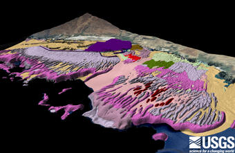
This comprises two distinct but interrelated efforts. First, we are conducting site-specific, high-resolution, benthic habitat mapping to support management of Department of the Interior areas (National Park Service park units, U.S. Fish & Wildlife Service refuges). The second effort is building on our expertise in benthic habitat mapping, watershed analysis, coastal circulation, sediment dynamics, submarine groundwater discharge, and numerical modeling to develop a comprehensive evaluation of US coral reefs. We are assessing all of the important geologic and oceanographic factors to identify those reefs most at risk and those reefs that are potentially the most resilient and the most likely to recover from an extreme event. The data produced through these efforts are being incorporated into multi-layered, interactive GIS databases for use by the scientific and management community overseeing US coral reefs.
Caption for large photo, top of page: Geo-referenced underwater image of Porites species corals imaged by a digital-towed camera system during a ground-truthing cruise in Kaloko-Honokōhau National Historical Park, Hawaiʻi.
Please also see the associated efforts on the Coral Reef Ecosystem Studies (CREST) Project website:
Learn more about our related studies.


We are mapping and assessing all of the important geologic and oceanographic factors to identify those coral reefs most at risk and those reefs that are potentially the most resilient and the most likely to recover from natural and human-driven impacts.
The Problem
Coral reefs are facing increasing stress from global climate change combined with local stresses from over-fishing, sedimentation, and other sources of land-based pollution. Considering the potential for these stressors to increase the rate of coral reef degradation to dire levels, coral reef scientists and managers world-wide are shifting emphasis from prevention towards identifying the key mechanisms controlling reef resiliency and determining where coral reefs will be the most viable in the future. Thus far, the scientific community has mostly focused on the biologic indicators of resiliency, such as coral cover, species diversity, and fish populations. The parameters that influence the health and sustainability of coral reefs are diverse and include changes in watersheds, coastal development, stream discharge, coastal circulation, wave stresses, and larval pathways. They also include potential natural processes that can potentially reduce stress (such as upwelling; internal wave mixing; submarine groundwater discharge). Identifying coral reef areas that have the highest potential for survival requires a cross-cutting assessment of all of the salient geographic, geologic, ecologic, and oceanographic factors. Less than half of the US National Parks and US Wildlife Refuges that contain coral reef resources have high-resolution assessments of their coral reefs. How does an agency manage today or predict what will happen under climate change when they don't know what resources they have or their current status? Furthermore, scientists and resource managers have noted that less than 1% of the U.S.’s coral reefs are fully protected, and that to preserve US coral reefs, a network of marine refuges must be established.
Our Approach
This comprises two distinct but interrelated efforts. First, we are conducting site-specific, high-resolution, benthic habitat mapping to support management of Department of the Interior areas (National Park Service park units, U.S. Fish & Wildlife Service refuges). The second effort is building on our expertise in benthic habitat mapping, watershed analysis, coastal circulation, sediment dynamics, submarine groundwater discharge, and numerical modeling to develop a comprehensive evaluation of US coral reefs. We are assessing all of the important geologic and oceanographic factors to identify those reefs most at risk and those reefs that are potentially the most resilient and the most likely to recover from an extreme event. The data produced through these efforts are being incorporated into multi-layered, interactive GIS databases for use by the scientific and management community overseeing US coral reefs.
Caption for large photo, top of page: Geo-referenced underwater image of Porites species corals imaged by a digital-towed camera system during a ground-truthing cruise in Kaloko-Honokōhau National Historical Park, Hawaiʻi.
Please also see the associated efforts on the Coral Reef Ecosystem Studies (CREST) Project website:
Learn more about our related studies.