
USGS supercomputers help assess volcanic hazards in support of community resilience
High-performance computing enables scientists to tackle complex problems and deliver faster volcanic hazard information for real-world impacts.
Volcanic hazards can be awe-inspiring displays of the Earth’s power, but each has the potential to threaten lives and infrastructure, as well as cultural and environmental resources.
Eruptions can last anywhere from hours to years and can produce a diverse and difficult to predict set of hazardous phenomena including explosions, earthquakes, ash clouds and deposits, lava flows, landslides, and lahars (high-speed floods of water, mud, and rocks). Worse still, these hazards can affect a wide range of areas, from near the vent (explosions) to regional (volcanic ash) to global (climatic changes due to volcanic gas dispersal in the stratosphere).
In the U.S., there are about 170 potentially active volcanoes, which are monitored by the USGS Volcano Hazards Program Volcano Science Center. The Center is home to the five regional observatories in Hawaiʻi, Alaska, the Cascades, California, and Yellowstone. USGS scientists at these observatories are responsible for monitoring these volcanoes as well as delivering forecasts, warnings, and information about volcano hazards while helping communities to be prepared during an eruption.

Globally, and especially in the US, many volcanoes erupt infrequently or in remote areas, so it is not surprising that gathering data on hazardous volcanic processes is difficult. This makes it hard for scientists to tease out which of the multiple hypotheses could explain volcanic processes.
Even in the lines of research related to volcanology where data is plentiful, such as seismology and satellite remote sensing, -- it can be difficult to recognize diagnostic patterns.
As a result of these challenges, USGS volcanologists are increasingly turning to computational tools.
These tools can range from simple models that can be computed in a spreadsheet up to large-scale geophysical and machine learning models that require high-performance computing (HPC) systems, sometimes referred to as supercomputers.
Supercomputers are put to the task
Fortunately for scientists, the USGS has three available HPC systems, supported by Core Science Systems Science Analytics and Synthesis group – named Denali, Tallgrass, and Hovenweep -- that can quickly and efficiently process very large datasets and solve complex systems of equations in geophysics.
Although each of these machines are different, their power is derived from the ability to split a large task into chunks, compute all the chunks “in parallel”, that is, at the same time on different processors, and then combine the results. This is noticeably different from running “serial” tasks on a single processor, where the chunks must be computed one after another.
The large increase in speed made possible by HPC systems also enables scientists to develop more complex data analysis techniques (such as machine learning models) as well as more sophisticated approaches to geophysical modeling (such as data assimilation and probabilistic hazards assessments).
Since the development of the first USGS supercomputer Yeti in 2013, USGS volcanologists have greatly increased their use of HPC resources, expanding both the complexity of the calculations and the range of applications.
HPC resources now commonly serve in a variety of real-world applications such as models of landslide and lahar scenarios at Mt. Rainier to ash fall hazards assessments to real-time forecasting of lava flows in Hawaiʻi, to machine learning of satellite-based volcano deformation data.
Looking into a volcano’s plumbing
Because many volcanic processes are too hazardous to observe up close or are otherwise inaccessible (for example, we can’t see underground), volcanologists rely upon other methods. Some of the data is captured after an area is safe to visit, while other geophysical methods such as seismicity, infrasound, and gravity changes, can be measured from a distance. In both cases, volcanologists seek to link these data to the processes that generated them using models of various kinds.
Recently, Dr. Roger Denlinger, Research Geophysicist at the Cascades Volcano Observatory led the largest active seismic experiment ever conducted at Kīlauea volcano, Hawaiʻi. Thousands of small temporary seismometers were deployed around the volcano summit which “listened” together for natural (passive) earthquakes as well as vibrations caused by an active seismic source mounted on a large truck.
Because both the truck-generated seismic waves and those received by the seismometers that have passed through the complex structure of Kīlauea are known, scientists can compute variations in density in the subsurface, enabling “imaging” of the volcano’s magma plumbing system. With an improved image of Kīlauea’s subsurface, the Hawaiian Volcano Observatory will be able to make improved assessments of volcanic hazards.
Of course, this imaging is easier said than done, requiring perhaps millions of computer hours to compute how volcanic features attenuate and scatter seismic waves below Kīlauea to match those recorded by the seismic network. Using a combination of machine learning tools and seismic geophysical models, USGS scientists are using Tallgrass and Hovenweep to tackle this monumental task.
“Machine learning methods help us monitor changes in volcanic systems and anticipate eruptions by probing the increasingly mind-numbing quantity of data that modern instrumentation produces,” says Denlinger. “For example, the Kīlauea imaging project is analyzing more than 200 million seismic waveforms to produce three-dimensional images of the magma system. This is physically impossible for any group of scientists to do by hand.”
Hazard forecasting for active volcanoes
Since the advent of using computational tools to model volcanic hazards, volcanologists have sought to be able to forecast volcanic eruptions and the hazards they produce. Although an eruption forecasting model is still only an area of active research, some volcanic hazards such as ash dispersal and lava flows have seen the development of robust forecasting models. These models focus on predicting where ash or lava will go in the case of an eruption and are often used in real time when and where these hazards appear.
Recently, USGS scientists have developed a new geophysical model called Lava2d to simulate how lava flows over the landscape during an eruption. Lava2d can produce very realistic model flows even when run with a coarse resolution, and its effectiveness was demonstrated during the 2022 eruption of Mauna Loa, Hawaiʻi. It was used to produce experimental forecasts in real time of where lava flows could inundate and how fast they would get there.

Most of these models were computed on the Yeti supercomputer, enabling the computation of thousands of runs with different lava flow properties and scenarios. These experimental forecasts were used by the Hawaiian Volcano Observatory to assess the possibility of future flow advance towards a major highway.
“USGS HPC resources have advanced our ability to accurately assess and forecast volcanic hazard before and during eruptions to protect life, property, and infrastructure in the US,” says Dr. Hannah Dietterich, Research Geophysicist at the Alaska Volcano Observatory and hazard modeling lead during the eruption. “Running large numbers of simulations allows us to generate better, more quantitative, and robust hazard information at volcanoes in the US but also elsewhere.”
Current research using the lava flow model Lava2d is focused on optimizing the model for use on Hovenweep, where it will be used to quickly compute high resolution lava flow forecasts when volcanoes in Hawaiʻi or the central Cascades next produce lava flows.
USGS HPC resources are also playing a significant role in longer-term volcanic hazard assessments, especially where volcanologists are planning for the next eruption of long-dormant volcanoes. In these cases, data on past hazards is limited to whatever lava or ash is still exposed at the surface. This can cause a great deal of uncertainty about the nature of “typical” volcanic materials for a given volcano.
When a model is run, the researcher needs to feed it specifications about material properties, ambient conditions, and the magnitude or size of the eruption. Unfortunately, these factors are typically highly uncertain, reducing the predictive value of any individual model run. However, if many models are made with different inputs, the collection of models, which researchers call an “ensemble”, work together to produce a much more probabilistic assessment of the hazard.
Complicating factors
This is particularly important for volcanic hazards that are greatly affected by atmospheric conditions, such as ash dispersal and deposition. Wind direction at the exact time the eruption occurs is a major factor controlling where volcanic ash will be deposited.
USGS researchers use a specific ash dispersal model, known as Ash3d, to compute how the wind will carry the ash and how quickly it will fall out of suspension.
Because wind direction and speed can vary so much, many thousands of Ash3d runs are required to capture the range of possible ashfall deposits. Running these very large jobs on supercomputers like Denali and Hovenweep allows the USGS to estimate the probability of ashfall in different locations for significant explosive eruptions in the future.

A similar ensemble modeling approach is in development for estimating the hazard posed by a variety of volcanic hazards including lava flows, ashfall, and lahars from Newberry Volcano near Bend, OR which last erupted in 690 CE.
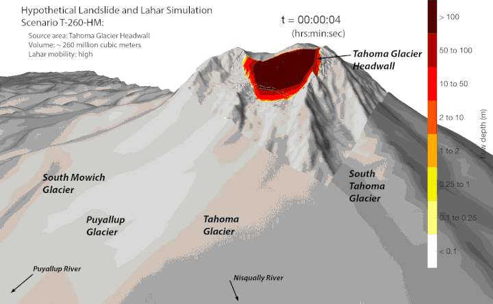
Landslides and lahars (high-speed floods of water, mud, and rocks) are other types of hazards that pose a unique computing challenge due to the complexity of the equations used to models them. The USGS uses a model known as D-Claw that incorporates sophisticated algorithms to simulate these highly destructive flows. To simulate the flows, D-Claw must first break down many related complex processes involved in the overall flow, such as levee formation, particle segregation, dilatancy, and pore pressurization. These highly complex dynamics require a sophisticated algorithm operating within a high-resolution grid.
Because of the high-resolution needed, D-Claw models tend to be very large in scale and are optimized for parallel computing on USGS HPC systems.
D-Claw was recently used to model lahar scenarios originating from possible landslide collapses high on Mt. Rainier, WA. These highly detailed models were used to estimate the hazard posed to communities downstream.
These are just a snapshot of applications of USGS HPC resources in volcanic hazards studies, but these tools are only gaining popularity and relevance. As more USGS scientists get the training needed to work on these machines, the free access to vast computational power that they offer them makes these HPC systems highly attractive settings for solving the big questions in volcanology. The gain in new knowledge accelerated by USGS HPC resources is helping to develop next-generation tools for assessing volcanic hazards, helping to protect and inform the public.

Dr. Tina Neal, Volcano Science Center Director, is excited to see this work into the future. “The application of HPC to volcano science is truly exciting to see flourish; from simulating ash cloud dispersal to modelling the complex motion of lava flows and lahars, results improve our scientific understanding of hazards and the quality of USGS decision support information for stakeholders.”
For more information or to get started using Denali, Tallgrass, or Hovenweep, contact us at hpc@usgs.gov.
Get Our News
These items are in the RSS feed format (Really Simple Syndication) based on categories such as topics, locations, and more. You can install and RSS reader browser extension, software, or use a third-party service to receive immediate news updates depending on the feed that you have added. If you click the feed links below, they may look strange because they are simply XML code. An RSS reader can easily read this code and push out a notification to you when something new is posted to our site.