
Mount with black-out curtain used to hold a wireless monitor. This set-up allows technicians to interface with four mini-PCs in real time, allowing them to check data and image quality, and make adjustments when necessary.
Images
Explore our planet through photography and imagery, including climate change and water all the way back to the 1800s when the USGS was surveying the country by horse and buggy.
Filter Total Items: 21545

Gear used for aerial photographic surveys
Mount with black-out curtain used to hold a wireless monitor. This set-up allows technicians to interface with four mini-PCs in real time, allowing them to check data and image quality, and make adjustments when necessary.

Measuring wildlife mortality
Scientists collect carcasses at a wind energy facility to estimate total wildlife mortality at a site.
Scientists collect carcasses at a wind energy facility to estimate total wildlife mortality at a site.

Melting snow created measurable flow in Reservation Creek
Melting snow near Miles City created measurable flow in Reservation Creek. This site is only visited when there are high flows,
Melting snow near Miles City created measurable flow in Reservation Creek. This site is only visited when there are high flows,

Calvert Formation near Plum Point, MD
Northeast Region Photo Contest Winner | March 2019 | USGS at Work
Seth Sutton at an outcrop of the marine Calvert Formation near Plum Point, MD, on the western shore of the Chesapeake Bay
Northeast Region Photo Contest Winner | March 2019 | USGS at Work
Seth Sutton at an outcrop of the marine Calvert Formation near Plum Point, MD, on the western shore of the Chesapeake Bay

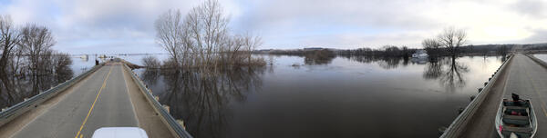
Spring 2019 Flooding - Big Sioux River
After record flooding on the Big Sioux River, USGS crews mobilized to take important water measurements.
After record flooding on the Big Sioux River, USGS crews mobilized to take important water measurements.

Spring 2019 Flooding - Big Sioux River, Akron, IA
After record flooding on the Big Sioux River, USGS crews mobilized to take important water measurements.
After record flooding on the Big Sioux River, USGS crews mobilized to take important water measurements.

USGS crews respond to flooding on the Big Sioux River
USGS technician Chris Broz helps take water measurements on the Big Sioux River during record flooding in March, 2019.
USGS technician Chris Broz helps take water measurements on the Big Sioux River during record flooding in March, 2019.

USGS crews respond to flooding on the Big Sioux River
USGS scientists and technicians took water measurements during flooding on the Big Sioux River near Hawarden, Iowa in March 2019.
USGS scientists and technicians took water measurements during flooding on the Big Sioux River near Hawarden, Iowa in March 2019.

USGS crews respond to flooding on the Big Sioux River
USGS technician Chris Broz helps take water measurements on the Big Sioux River during record flooding in March, 2019.
USGS technician Chris Broz helps take water measurements on the Big Sioux River during record flooding in March, 2019.
USGS takes water measurements during Big Sioux flooding
USGS scientists and technicians took water measurements during flooding on the Big Sioux River near Jefferson, SD in March 2019. Measurements for this site were 52,000 cfs at a gage height of 40.14 ft.
USGS scientists and technicians took water measurements during flooding on the Big Sioux River near Jefferson, SD in March 2019. Measurements for this site were 52,000 cfs at a gage height of 40.14 ft.

Spring 2019 Flooding - Big Sioux River
After record flooding on the Big Sioux River, USGS crews mobilized to take important water measurements.
After record flooding on the Big Sioux River, USGS crews mobilized to take important water measurements.

Spring 2019 Flooding - Big Sioux River, Hawarden, IA
After record flooding on the Big Sioux River, USGS crews mobilized to take important water measurements.
After record flooding on the Big Sioux River, USGS crews mobilized to take important water measurements.

HVO geologists make field observations in the lower East Rift Zone
What does a hardened lava flow look like? This photograph is of the frothy top of a lava flow near the fissure 8 vent, on Kīlauea Volcano's lower East Rift Zone. The different sizes and abundance of bubbles in the surface texture create different colors of the lava, including the light brown and darker black near the boot (for scale).
What does a hardened lava flow look like? This photograph is of the frothy top of a lava flow near the fissure 8 vent, on Kīlauea Volcano's lower East Rift Zone. The different sizes and abundance of bubbles in the surface texture create different colors of the lava, including the light brown and darker black near the boot (for scale).

Wind trubines and photovoltaic cell array and transmission lines
Blended photo of a wind and solar energy facilities.
Blended photo of a wind and solar energy facilities.

Dive Camera System Ready to Deploy In Lake Ontario
An integrated camera and scooter system is ready to deploy in Lake Ontario. The camera is used to record circular transects.
An integrated camera and scooter system is ready to deploy in Lake Ontario. The camera is used to record circular transects.

Diver swimming a circular transect
This SCUBA diver is using a camera integrated with a scooter running a circular transect. The white line attached to the scooter is also attached to a pivot point at the center of the sample area.
This SCUBA diver is using a camera integrated with a scooter running a circular transect. The white line attached to the scooter is also attached to a pivot point at the center of the sample area.

Making repairs at the Green Island streamgage on the Hudson River
Sean Stewart and Brendan Hallmark making repairs at the Green Island streamgage (01358000) on the Hudson River. Photo by Travis Smith (Public Domain)
Sean Stewart and Brendan Hallmark making repairs at the Green Island streamgage (01358000) on the Hudson River. Photo by Travis Smith (Public Domain)


Preparing the aircraft to leave Oxnard Airport
Preparing the Partenavia aircraft to leave Oxnard Airport for a survey.
The Seabird Studies Team at the USGS Western Ecological Research Center is conducting aerial photographic surveys of the ocean off central and southern California to create comprehensive maps of seabird and marine mammal distributions.

Sulfur deposits forming in the new Halema‘uma‘u crater
Telephoto zoom of the largest sulfur deposit forming on the NE talus wall in Halema‘uma‘u. The view is from the
USGS Hawaiian Volcano Observatory's K3cam. Images can be viewed on HVO's website at https://volcanoes.usgs.gov/observatories/hvo/webcam.html?webcam=K3cam.
Telephoto zoom of the largest sulfur deposit forming on the NE talus wall in Halema‘uma‘u. The view is from the
USGS Hawaiian Volcano Observatory's K3cam. Images can be viewed on HVO's website at https://volcanoes.usgs.gov/observatories/hvo/webcam.html?webcam=K3cam.

USGS field biologist Andrea Mott displays a recently marked goose
USGS field biologist Andrea Mott displays a recently marked Lesser Snow Goose.
USGS field biologist Andrea Mott displays a recently marked Lesser Snow Goose.