
Northeast Region Photo Contest Winner | February 2019 | Honorable Mention
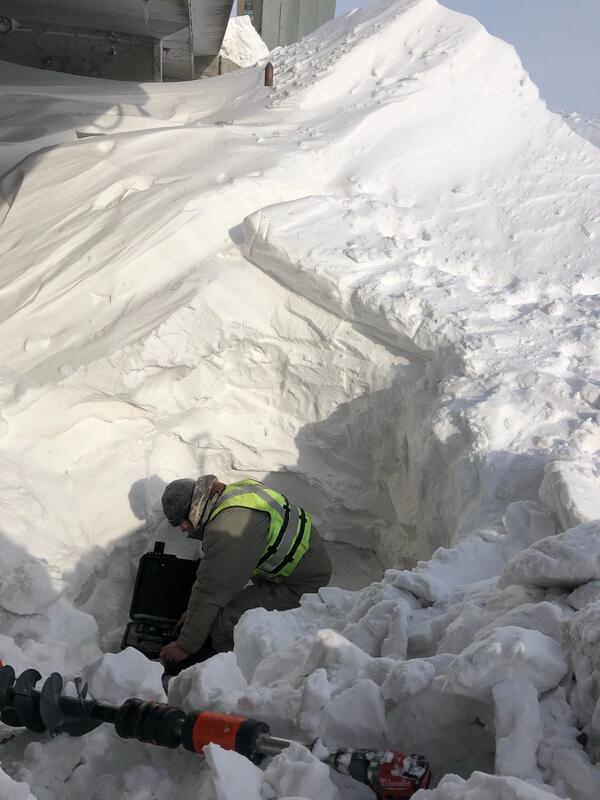
Glenn Berwick installing RDG below ice jam
Images
Explore our planet through photography and imagery, including climate change and water all the way back to the 1800s when the USGS was surveying the country by horse and buggy.
Filter Total Items: 21545

Glenn Berwick installing RDG below ice jam
Northeast Region Photo Contest Winner | February 2019 | Honorable Mention
Glenn Berwick installing RDG below ice jam

HABS platform removal
Matthew Jennings and Andrew Kowalczk breaking ice on the boat ramp before retrieving the Harmful Algal Bloom Data Collection Platform moored in Seneca Lake, NY.
Matthew Jennings and Andrew Kowalczk breaking ice on the boat ramp before retrieving the Harmful Algal Bloom Data Collection Platform moored in Seneca Lake, NY.

New Fork River Sample Collection
We are using this piece of equipment to instantly measure stream temperature, pH, dissolved oxygen, and electrical conductivity. When you move the probe up and down in the water column, you can tell if the stream has stratification.
We are using this piece of equipment to instantly measure stream temperature, pH, dissolved oxygen, and electrical conductivity. When you move the probe up and down in the water column, you can tell if the stream has stratification.

Twilight in the Northern Bristol Mountains
Rain clouds at twilight over the Norhtern Bristol Mountains. THese types of winter storms provide water to the desert ecosystem, but are not usually intense enough to transport sediment or do other geomorphic work.
Rain clouds at twilight over the Norhtern Bristol Mountains. THese types of winter storms provide water to the desert ecosystem, but are not usually intense enough to transport sediment or do other geomorphic work.

USGS to survey Kīlauea Volcano from its summit to Kumukahi
Areas on Kīlauea that will be covered by a helicopter lidar survey in June 2019. Red lines enclose areas over which the survey helicopter will fly at 396 m (1,300 ft) above ground level. Green lines enclose areas over which the helicopter will fly at 151 m (500 ft) above ground level. USGS map.
Areas on Kīlauea that will be covered by a helicopter lidar survey in June 2019. Red lines enclose areas over which the survey helicopter will fly at 396 m (1,300 ft) above ground level. Green lines enclose areas over which the helicopter will fly at 151 m (500 ft) above ground level. USGS map.

A sea turtle mosaic made from the field station's broken floor tiles
After Hurricane Michael obliterated Fish Inn, the sea turtle research team's field station, team members salvaged some of the building's floor tiles and made this sea turtle mosaic, which they plan to eventually install in a new field station.
After Hurricane Michael obliterated Fish Inn, the sea turtle research team's field station, team members salvaged some of the building's floor tiles and made this sea turtle mosaic, which they plan to eventually install in a new field station.
Winter Streamflow Measurement at the Rush River at Amenia, ND
USGS Hydrologic Technician Chris Broz attempting to find flow at the Rush River at Amenia, ND (USGS streamgage 05060500). It took the technicians an hour to dig through the snow drift under the wire weight gage just to get to the ice. Then they drilled holes in the ice so they could see if there was any water to measure.
USGS Hydrologic Technician Chris Broz attempting to find flow at the Rush River at Amenia, ND (USGS streamgage 05060500). It took the technicians an hour to dig through the snow drift under the wire weight gage just to get to the ice. Then they drilled holes in the ice so they could see if there was any water to measure.

Mohawk River at Lock 9 at Rotterdam Junction, NY
Mohawk River at Lock 9 at Rotterdam Junction, NY
Mohawk River at Lock 9 at Rotterdam Junction, NY

Measuring streamflow on the Middle Fork Crow River near Spicer, MN
USGS hydrologist Erich Kessler prepares to measure the stream stage (the height of the water surface) of the Middle Fork Crow River near Spice, Minnestota.
USGS hydrologist Erich Kessler prepares to measure the stream stage (the height of the water surface) of the Middle Fork Crow River near Spice, Minnestota.

Streamflow Measurement Through the Ice
Winter fieldwork often requires a few extra steps in gaining access to collection sites. In this image, a USGS employee measures streamflow through holes drilled in the ice using an auger.
Winter fieldwork often requires a few extra steps in gaining access to collection sites. In this image, a USGS employee measures streamflow through holes drilled in the ice using an auger.

USGS EROS Researchers in Idaho
USGS EROS contractor Minsu Kim, left, and USGS Scientist Jeffrey Danielson stand with a GPS device in northern Idaho, where they were part of a research project to conduct topobathymetric research along the Kootenai River of northern Idaho.
USGS EROS contractor Minsu Kim, left, and USGS Scientist Jeffrey Danielson stand with a GPS device in northern Idaho, where they were part of a research project to conduct topobathymetric research along the Kootenai River of northern Idaho.

Winter Streamflow
Using Doppler to peer under the ice and measure streamflow at New Fork River near Big Piney, Wyoming.
Using Doppler to peer under the ice and measure streamflow at New Fork River near Big Piney, Wyoming.

Map showing the three types of young faults in Yellowstone National Park.
Map showing the three types of young faults in Yellowstone National Park. Courtesy of the Wyoming State Geological Survey.
Map showing the three types of young faults in Yellowstone National Park. Courtesy of the Wyoming State Geological Survey.

Mohawk River at Vischer Ferry Dam, NY
Mohawk RIver at Vischer Ferry Dam Ice Jam camera
Mohawk RIver at Vischer Ferry Dam Ice Jam camera


Unuk River in Winter
Unuk River sampling site.
Unuk River sampling site.

East Fork Whitewater River at Richmond IN - equipment on bridge
East Fork Whitewater River at Richmond IN - equipment on bridge
East Fork Whitewater River at Richmond IN - equipment on bridge

Adaptive Management Forum Brochure
Adaptive Management Forum Brochure.This conference was held at the University of California, Davis on February 5-6, 2019.
Adaptive Management Forum Brochure.This conference was held at the University of California, Davis on February 5-6, 2019.

Employee Using an Ice Auger
A USGS employee uses a motorized auger to drill a two-foot hole in the ice for the purpose of measuring streamflow on the Sweetwater River. This image shows the final stages of the drilling process for one hole out of the twelve drilled that day.
A USGS employee uses a motorized auger to drill a two-foot hole in the ice for the purpose of measuring streamflow on the Sweetwater River. This image shows the final stages of the drilling process for one hole out of the twelve drilled that day.

Forcing an Auger through Thick Ice
A USGS employee uses a motorized auger to drill a two-foot hole in the ice for the purpose of measuring streamflow on the Sweetwater River. This image shows the beginning stages of the drilling process for one hole out of the twelve drilled that day.
A USGS employee uses a motorized auger to drill a two-foot hole in the ice for the purpose of measuring streamflow on the Sweetwater River. This image shows the beginning stages of the drilling process for one hole out of the twelve drilled that day.

Hawaii that extend offshore
Many of the earthquakes in Hawaii that extend offshore and up the island chain are due to plate bending, or flexure. The upper panel shows magnitude-5 and greater earthquakes since 1861, with some notable events labeled.
Many of the earthquakes in Hawaii that extend offshore and up the island chain are due to plate bending, or flexure. The upper panel shows magnitude-5 and greater earthquakes since 1861, with some notable events labeled.