USGS Library has an expansive map collection with topographic maps, geologic maps, thematic maps, and more. The collection covers the United States, other countries around the world, and other planets.
By

Official websites use .gov
A .gov website belongs to an official government organization in the United States.
Secure .gov websites use HTTPS
A lock () or https:// means you’ve safely connected to the .gov website. Share sensitive information only on official, secure websites.
Explore our planet through photography and imagery, including climate change and water all the way back to the 1800s when the USGS was surveying the country by horse and buggy.

USGS Library has an expansive map collection with topographic maps, geologic maps, thematic maps, and more. The collection covers the United States, other countries around the world, and other planets.
USGS Library has an expansive map collection with topographic maps, geologic maps, thematic maps, and more. The collection covers the United States, other countries around the world, and other planets.

USGS Library in Menlo Park has a collection of aerial photos that researchers can use when visiting the library.
USGS Library in Menlo Park has a collection of aerial photos that researchers can use when visiting the library.

U.S. Geological Survey (USGS) scientist working on data analysis of cyanotoxins in water samples
U.S. Geological Survey (USGS) scientist working on data analysis of cyanotoxins in water samples

A USGS scientist prepares a sample to test the effect of antibiotics on denitrifying bacteria within a glove box. A glove box allows scientists to work with samples in an anaerobic (no oxygen) atmosphere, the conditions under which denitrification occurs.
A USGS scientist prepares a sample to test the effect of antibiotics on denitrifying bacteria within a glove box. A glove box allows scientists to work with samples in an anaerobic (no oxygen) atmosphere, the conditions under which denitrification occurs.

Screenshot of a point cloud containing more than 50 million points from a photogrammetry project of the Quissett Campus. This point cloud was created from 633 photographs taken from a unmanned aircraft system (UAS) in Woods Hole, Massachusetts in July 2018
Screenshot of a point cloud containing more than 50 million points from a photogrammetry project of the Quissett Campus. This point cloud was created from 633 photographs taken from a unmanned aircraft system (UAS) in Woods Hole, Massachusetts in July 2018

Murulee Byappanahalli GLSC; Lake Michigan Ecological Research Station; LMERS; Chesterton, Indiana, IN; students from Indiana University Northwest visit to learn about microbiology science and applications; outreach;
Murulee Byappanahalli GLSC; Lake Michigan Ecological Research Station; LMERS; Chesterton, Indiana, IN; students from Indiana University Northwest visit to learn about microbiology science and applications; outreach;

Web cam mounted near USGS gaging station site number 12046260, looking upstream from the water supply diversion structure on the lower Elwha River near Port Angeles in Washington.
Web cam mounted near USGS gaging station site number 12046260, looking upstream from the water supply diversion structure on the lower Elwha River near Port Angeles in Washington.

Eosin-nigrosin staining of spermatozoa from common carp (Cyprinus carpio) testes collected from the Lake Mead National Recreation Area, Nevada
Eosin-nigrosin staining of spermatozoa from common carp (Cyprinus carpio) testes collected from the Lake Mead National Recreation Area, Nevada

Keith A. Loftin, USGS, is the lead scientist for algal and cyanobacterial toxins
Keith A. Loftin, USGS, is the lead scientist for algal and cyanobacterial toxins

Microscopic video imaging is used for computerized analysis of sperm motility parameters
Microscopic video imaging is used for computerized analysis of sperm motility parameters
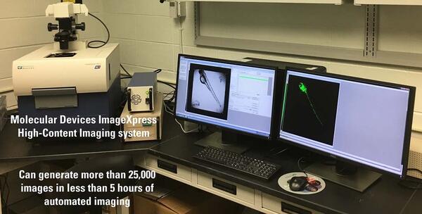
Molecular Devices ImageXpress† High-Content Imaging System that can generate more than 25,000 images in less than 5 hours of automated image acquisition.
Molecular Devices ImageXpress† High-Content Imaging System that can generate more than 25,000 images in less than 5 hours of automated image acquisition.
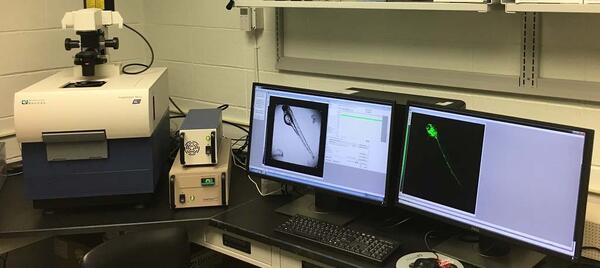
Molecular Devices ImageXpress† High-Content Imaging System
Molecular Devices ImageXpress† High-Content Imaging System

Tablet-enabled field forms have been developed to help coordinate field efforts, collect site information, GPS coordinates, photos, and control data collection.
Tablet-enabled field forms have been developed to help coordinate field efforts, collect site information, GPS coordinates, photos, and control data collection.

USGS scientists evaluating the nebulizer assembly in a mixed mode ionization source of a triple quadrupole mass spectrometer used to measure individual cyanotoxins
USGS scientists evaluating the nebulizer assembly in a mixed mode ionization source of a triple quadrupole mass spectrometer used to measure individual cyanotoxins
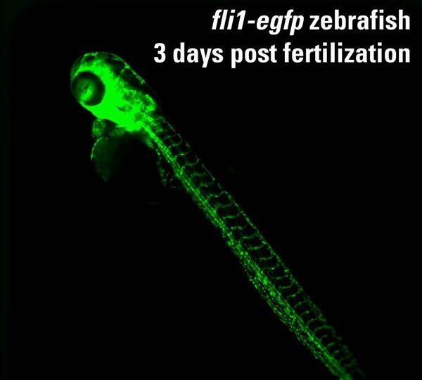
Using the 384-well plate format, a single zebrafish embryo is tested in each well. This is an example of a 72 hour post fertilization fli1:egfp zebrafish (3 millimeters long) imaged under a fluorescein isothiocyanate (FITC) filter.
Using the 384-well plate format, a single zebrafish embryo is tested in each well. This is an example of a 72 hour post fertilization fli1:egfp zebrafish (3 millimeters long) imaged under a fluorescein isothiocyanate (FITC) filter.

Leidy Creek near Moran (13012465) streamgage
Leidy Creek near Moran (13012465) streamgage

An otolith, sometimes called “earstone,” of a bloater, a small prey fish in the Great Lakes. Fishery scientists interpret the age of bloater and other fishes by counting annual growth rings on their otoliths.
An otolith, sometimes called “earstone,” of a bloater, a small prey fish in the Great Lakes. Fishery scientists interpret the age of bloater and other fishes by counting annual growth rings on their otoliths.

South Fork Spread Creek near Moran (13012475) streamgage
South Fork Spread Creek near Moran (13012475) streamgage

USGS hydrologic technician Rob Forde flags a high water mark above the eaves at Presbyterian Church of the Covenant, 118 Manchester Road, Spring Hill, North Carolina on Sept. 21, 2018, in the wake of flooding brought on by Hurricane Florence.
USGS hydrologic technician Rob Forde flags a high water mark above the eaves at Presbyterian Church of the Covenant, 118 Manchester Road, Spring Hill, North Carolina on Sept. 21, 2018, in the wake of flooding brought on by Hurricane Florence.

Biologists from the USGS and Nature Conservancy identify a small fish captured during a September electrofishing survey on a tributary to Follensby Pond, Adirondack Mountains, New York
Biologists from the USGS and Nature Conservancy identify a small fish captured during a September electrofishing survey on a tributary to Follensby Pond, Adirondack Mountains, New York

Field of Phragmites near Cedar Point, Ohio.