
Grand Teton National Park in autumn.
Images
Explore our planet through photography and imagery, including climate change and water all the way back to the 1800s when the USGS was surveying the country by horse and buggy.
Filter Total Items: 21545

Grand Teton National Park in autumn.
Grand Teton National Park in autumn.

Collage of USGS staff in the field
Upper Left: Dann Blackwood operating the SEABOSS winch during a sampling cruise; Lower left: Bill Schwab, Laura Brothers and Emile Bergeron on the deck of a research vessel; Center Left: Tom O'Brien carrying equipment during a research cruise; Center: USGS staff deploying a seismic system from a research vessel; left: Chuck Worley ready to deploy a multibeam e
Upper Left: Dann Blackwood operating the SEABOSS winch during a sampling cruise; Lower left: Bill Schwab, Laura Brothers and Emile Bergeron on the deck of a research vessel; Center Left: Tom O'Brien carrying equipment during a research cruise; Center: USGS staff deploying a seismic system from a research vessel; left: Chuck Worley ready to deploy a multibeam e
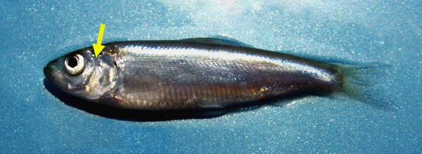
Location of Otolith Inside Alewife
Otoliths are located directly behind the brain of bony fishes. On the young alewife shown here, the approximate location of the otoliths is noted with a yellow arrow.
Otoliths are located directly behind the brain of bony fishes. On the young alewife shown here, the approximate location of the otoliths is noted with a yellow arrow.

New outcrops make good geology
This aerial view of the western part of Kīlauea Volcano's caldera was taken on August 6, 2018. The down-dropped block is faulted about 120 m (400 feet) below the caldera floor. Many 19th-century lava flows are exposed in the fault scarps. Halema‘uma‘u (not visible) is to the left of this photo. USGS photo by D.Swanson.
This aerial view of the western part of Kīlauea Volcano's caldera was taken on August 6, 2018. The down-dropped block is faulted about 120 m (400 feet) below the caldera floor. Many 19th-century lava flows are exposed in the fault scarps. Halema‘uma‘u (not visible) is to the left of this photo. USGS photo by D.Swanson.

Skinny Common Murre with keel protruding
Skinny Common Murre with keel protruding. Lower Cook Inlet, Alaska
Skinny Common Murre with keel protruding. Lower Cook Inlet, Alaska

ECCC Robot Assisted Vision Slide 1
ECCC Robot Assisted Vision Slide Two
ECCC Robot Assisted Vision Slide Two

Treating Phragmites in the Laboratory
The untreated non-native Phragmites plant (left) appears healthy; the organically treated plants (right) appear dead.
The untreated non-native Phragmites plant (left) appears healthy; the organically treated plants (right) appear dead.

Whitebark pine cone, opened and in a seed trap
Whitebark pine cone on a seed trap
Whitebark pine cone on a seed trap

Former site of San Clemente Dam, Carmel River
San Clemente Dam was a 106-foot-high concrete arch dam that was located approximately 18.5 miles from the Pacific Ocean on the Carmel River. It was built in 1921 to create a reservoir to support the growing residential, agricultural, and tourism-related development.
San Clemente Dam was a 106-foot-high concrete arch dam that was located approximately 18.5 miles from the Pacific Ocean on the Carmel River. It was built in 1921 to create a reservoir to support the growing residential, agricultural, and tourism-related development.

Measuring a high water mark as flooding recedes
USGS hydrographer Kyle Marchman measures a high water mark on the rear wall of a Kangaroo gas station on Highway 24 north of Fayetteville, NC on Sept. 18, 2018, after flooding caused by Hurricane Florence.
USGS hydrographer Kyle Marchman measures a high water mark on the rear wall of a Kangaroo gas station on Highway 24 north of Fayetteville, NC on Sept. 18, 2018, after flooding caused by Hurricane Florence.

Parrotfish grazing on coral in Buck Island Reef National Monument
Parrotfish grazing on coral within an Acropora palmata framework in Buck Island Reef National Monument
Parrotfish grazing on coral within an Acropora palmata framework in Buck Island Reef National Monument

Measuring the Lumber River floodwaters
James Stonecypher measures flood waters from the Lumber River that breached a dam in Lumberton, North Carolina after the passage of Hurricane Florence, Sept. 17, 2018.
James Stonecypher measures flood waters from the Lumber River that breached a dam in Lumberton, North Carolina after the passage of Hurricane Florence, Sept. 17, 2018.

Mules loaded with sampling equipment and supplies, Yellowstone
Mules loaded with sampling equipment and supplies for a mission to collect gas and thermal water samples from the Bechler River area in the southwest part of Yellowstone National Park.
Mules loaded with sampling equipment and supplies for a mission to collect gas and thermal water samples from the Bechler River area in the southwest part of Yellowstone National Park.

Outstanding in the field
USGS Research Geologist Dr. Erika Lentz is conducting real-time kinematic GPS surveys on barrier island dunes, part of her research looking at how coastal landscapes respond to sea-level rise.
USGS Research Geologist Dr. Erika Lentz is conducting real-time kinematic GPS surveys on barrier island dunes, part of her research looking at how coastal landscapes respond to sea-level rise.

Thermal feature along Ferris Fork near Bechler River, Yellowstone
An unnamed but charismatic thermal feature alongside Ferris Fork, near the Bechler River. The center of the pool is roiling with gas bubbles, but not boiling! The pool is only about 180 degrees F (81 degrees C), and all the gas is bubbling up from underground.
An unnamed but charismatic thermal feature alongside Ferris Fork, near the Bechler River. The center of the pool is roiling with gas bubbles, but not boiling! The pool is only about 180 degrees F (81 degrees C), and all the gas is bubbling up from underground.
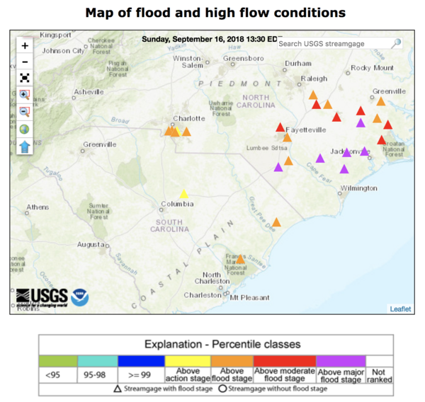
As Florence rains, rivers keep rising, submerging some USGS instrument
A WaterWatch web map shows streamgages in North and South Carolina that approached or exceeded major flood stage EST on September 19, 2018, as the former Hurricane Florence, now downgraded to a tropical depression, deluged the states with rain.
A WaterWatch web map shows streamgages in North and South Carolina that approached or exceeded major flood stage EST on September 19, 2018, as the former Hurricane Florence, now downgraded to a tropical depression, deluged the states with rain.

Cottonwood Fire, 2016
October 16, 2018, marks the two-year anniversary of the Cottonwood Fire in western South Dakota. The fire consumed a large swath of grassland near the community of Wall and just north of Badlands National Park.
October 16, 2018, marks the two-year anniversary of the Cottonwood Fire in western South Dakota. The fire consumed a large swath of grassland near the community of Wall and just north of Badlands National Park.

Did groundwater trigger explosive eruptions at Kīlauea?
Explosive eruption columns of ash rising from Halema‘uma‘u at 11:15 a.m. on May 18, 1924 (top) and at 11:05 a.m. on May 15, 2018 (bottom) look similar.
Explosive eruption columns of ash rising from Halema‘uma‘u at 11:15 a.m. on May 18, 1924 (top) and at 11:05 a.m. on May 15, 2018 (bottom) look similar.

Ear Spring, Yellowstone National Park
Ear Spring photographed on September 16, 2018. Rocks and other debris on the ground surrounding the spring were ejected during the September 15 water eruption. The spring is dry in this photo.
Ear Spring photographed on September 16, 2018. Rocks and other debris on the ground surrounding the spring were ejected during the September 15 water eruption. The spring is dry in this photo.

Following the draining of magma from Pu‘u ‘Ō‘ō on Ap
Following the draining of magma from Pu‘u ‘Ō‘ō on April 30, 2018, the crater was roughly 356 meters (1168 feet) deep. The upper part of the crater was flaring, with the deepest portion a narrower cylindrical shaft.
Following the draining of magma from Pu‘u ‘Ō‘ō on April 30, 2018, the crater was roughly 356 meters (1168 feet) deep. The upper part of the crater was flaring, with the deepest portion a narrower cylindrical shaft.

Working to keep vital flood information flowing in the Carolinas
David Stillwell, USGS hydrologic technician, performs a discharge measurement to help document and forecast flooding caused by Hurricane Florence at Long Creek in Rhyne, North Carolina on Sept. 16.
David Stillwell, USGS hydrologic technician, performs a discharge measurement to help document and forecast flooding caused by Hurricane Florence at Long Creek in Rhyne, North Carolina on Sept. 16.