
Audience at California's Premier Adaptation Gathering
Images
Explore our planet through photography and imagery, including climate change and water all the way back to the 1800s when the USGS was surveying the country by horse and buggy.
Filter Total Items: 21545

Audience at California's Premier Adaptation Gathering
Audience at California's Premier Adaptation Gathering

Audience at California's Premier Adaptation Gathering
Audience at California's Premier Adaptation Gathering
Audience at California's Premier Adaptation Gathering

Burning Man's Temporary City
Burning Man is named for the wooden effigy set ablaze at the end of the weeklong celebration in the temporary metropolis of Black Rock City.
Burning Man is named for the wooden effigy set ablaze at the end of the weeklong celebration in the temporary metropolis of Black Rock City.

A fisheries technician prepares to release a tagged pallid sturgeon
A fisheries technician prepares to release a tagged pallid sturgeon into the Yellowstone River, Montana
A fisheries technician prepares to release a tagged pallid sturgeon into the Yellowstone River, Montana

50,000 tons of sulfur dioxide gas per day
In mid-July 2018, fissure 8 (shown here) on Kīlauea Volcano's lower East Rift Zone was emitting more than 50,000 tons of sulfur dioxide gas per day, creating high levels of vog on the island. Since early August, lower East Rift Zone SO2 emissions have dropped to less than 100 tons per day, resulting in better air quality for Hawaii.
In mid-July 2018, fissure 8 (shown here) on Kīlauea Volcano's lower East Rift Zone was emitting more than 50,000 tons of sulfur dioxide gas per day, creating high levels of vog on the island. Since early August, lower East Rift Zone SO2 emissions have dropped to less than 100 tons per day, resulting in better air quality for Hawaii.

Impact of Hurricane Lane on Wailuku River
Two views from the Rainbow Falls overlook, downstream of the Wailuku River streamgage near Hilo, Hawaii. The image on the left shows a typical base flow of about 35 cubic feet per second (cfs). The image on the right shows the early impact of Hurricane Lane with a flow of about 26,000 cfs taken at 8:35 a.m. HST, August 23, 2018. This U.S.
Two views from the Rainbow Falls overlook, downstream of the Wailuku River streamgage near Hilo, Hawaii. The image on the left shows a typical base flow of about 35 cubic feet per second (cfs). The image on the right shows the early impact of Hurricane Lane with a flow of about 26,000 cfs taken at 8:35 a.m. HST, August 23, 2018. This U.S.

Skinny Common Murre flying with keel protruding
Skinny Common Murre with keel protruding. Lower Cook Inlet, Alaska
Skinny Common Murre with keel protruding. Lower Cook Inlet, Alaska

View of Unalakleet from the air
Unalakleet village on the low-lying barrier spit at the inlet of the Unalakleet River and Norton Sound, Alaska.
Unalakleet village on the low-lying barrier spit at the inlet of the Unalakleet River and Norton Sound, Alaska.

Why do some Hawaii earthquakes occur so far offshore?
Many of the earthquakes in Hawaii that extend offshore and up the island chain are due to plate bending, or flexure. The upper panel shows magnitude-5 and greater earthquakes since 1861, with some notable events labeled.
Many of the earthquakes in Hawaii that extend offshore and up the island chain are due to plate bending, or flexure. The upper panel shows magnitude-5 and greater earthquakes since 1861, with some notable events labeled.
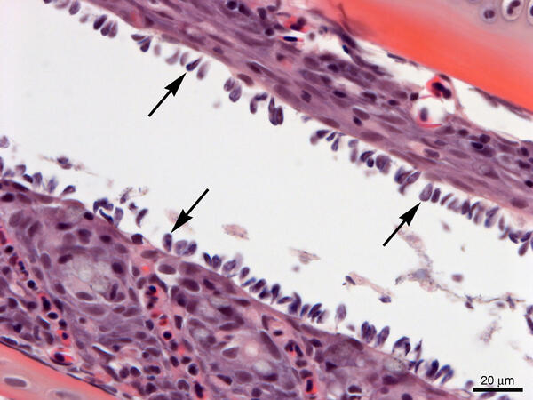
Gills from Lost River Suckers - heavy infestation of Ichthyobodo sp.
Gills from Lost River suckers with a heavy infestation of Ichthyobodo sp. (arrows). Slide is stained with hematoxylin and eosin.
Gills from Lost River suckers with a heavy infestation of Ichthyobodo sp. (arrows). Slide is stained with hematoxylin and eosin.

A Peregrine Falcon flies off with a Black-legged Kittiwake
A Peregrine Falcon flies off with a Black-legged Kittiwake from its colony at Gull Island, Alaska.
A Peregrine Falcon flies off with a Black-legged Kittiwake from its colony at Gull Island, Alaska.

Documenting August 2018 flooding in the Madison, Wisconsin, area
A USGS hydrologist documents a flooded street near the Sugar River in Verona, Wisconsin. This image was taken after the area received near-record rainfall on August 20, 2018.
A USGS hydrologist documents a flooded street near the Sugar River in Verona, Wisconsin. This image was taken after the area received near-record rainfall on August 20, 2018.

One Year Ago: Total Eclipse Darkens Nebraska Sandhills
A total solar eclipse darkened the skies over the United States on Aug. 21, 2017.
Oshkosh, a town in the Nebraska Sandhills, was a prime location for viewing the eclipse. This Landsat 7 image shows the town at 11:33 a.m. local time on Aug. 18, 2016, a year before the total eclipse.
A total solar eclipse darkened the skies over the United States on Aug. 21, 2017.
Oshkosh, a town in the Nebraska Sandhills, was a prime location for viewing the eclipse. This Landsat 7 image shows the town at 11:33 a.m. local time on Aug. 18, 2016, a year before the total eclipse.

Twentymile River sonar on a bridge
Twentymile River sonar on a bridge
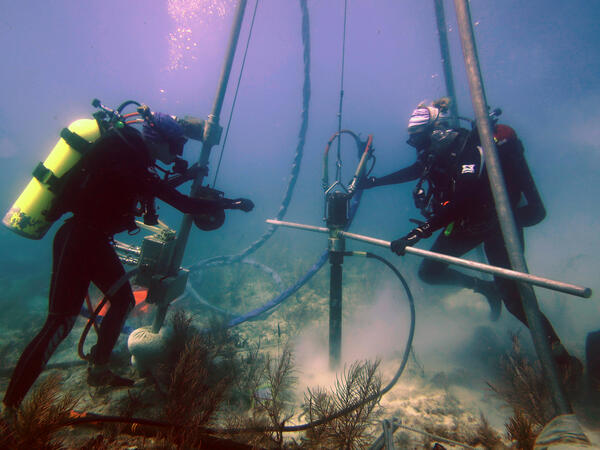
USGS scientists drill a coral-reef core in the Florida Keys
Research Oceanographer Lauren Toth and student volunteer Liz Whitcher drill a coral-reef core from a reef off Key West, Florida, in the Florida Keys National Marine Sanctuary. Photo taken under research permit FKNMS-2015-058. Credit: Anastasios Stathakopoulos, USGS.
Research Oceanographer Lauren Toth and student volunteer Liz Whitcher drill a coral-reef core from a reef off Key West, Florida, in the Florida Keys National Marine Sanctuary. Photo taken under research permit FKNMS-2015-058. Credit: Anastasios Stathakopoulos, USGS.

Yellowstone National Park Dragonfly Mercury Project Sampling
This image shows citizen scientists along with National Park Service personnel identifying invertebrates as part of the Dragonfly Mercury Project.
This image shows citizen scientists along with National Park Service personnel identifying invertebrates as part of the Dragonfly Mercury Project.

7 months of no lava at Pu‘u ‘Ō‘ō heralds end of an e
Pu‘u ‘Ō‘ō on May 3, 2018, as viewed from the helicopter overflight. The crater floor is collapsed, and a thin plume escapes from the gaping crater. The west flank cracked on April 30th around 2:30 pm HST, and minor amounts of lava oozed out of the crack (line of steaming features) just before the plumbing system catastrophically failed.
Pu‘u ‘Ō‘ō on May 3, 2018, as viewed from the helicopter overflight. The crater floor is collapsed, and a thin plume escapes from the gaping crater. The west flank cracked on April 30th around 2:30 pm HST, and minor amounts of lava oozed out of the crack (line of steaming features) just before the plumbing system catastrophically failed.

A sensor data logger recovered from the floor of Yellowstone Lake in the Deep Ho
A sensor data logger recovered from the floor of Yellowstone Lake in the Deep Hole area in 2018 shows signs of melting due to unexpectedly high temperatures in sediments up to ~3 ft (1 m) away from an active hydrothermal vent. Image acquired by the Global Foundation for Ocean Exploration ROV Yogi on August 4, 2018.
A sensor data logger recovered from the floor of Yellowstone Lake in the Deep Hole area in 2018 shows signs of melting due to unexpectedly high temperatures in sediments up to ~3 ft (1 m) away from an active hydrothermal vent. Image acquired by the Global Foundation for Ocean Exploration ROV Yogi on August 4, 2018.

Hot spring waters with relatively high dissolved element concentrations on the f
Hot spring waters with relatively high dissolved element concentrations on the floor of West Thumb, Yellowstone Lake. Image acquired by the Global Foundation for Ocean Exploration ROV Yogi on August 7, 2018.
Hot spring waters with relatively high dissolved element concentrations on the floor of West Thumb, Yellowstone Lake. Image acquired by the Global Foundation for Ocean Exploration ROV Yogi on August 7, 2018.

InSAR image of Yellowstone spanning 2004-2006
Color bands in this radar interferogram depict the pattern of surface deformation at the Yellowstone caldera from September 22, 2004, to August 23, 2006. The southwest and northeast parts of the caldera floor rose about 11 cm (4.3 inches) and 15 cm (5.9 inches), respectively, while the north caldera rim near Norris Geyser Basin subsided about 7 cm (2.8 inches).
Color bands in this radar interferogram depict the pattern of surface deformation at the Yellowstone caldera from September 22, 2004, to August 23, 2006. The southwest and northeast parts of the caldera floor rose about 11 cm (4.3 inches) and 15 cm (5.9 inches), respectively, while the north caldera rim near Norris Geyser Basin subsided about 7 cm (2.8 inches).

Scientific crew and drone operators
Scientific crew and drone operators. Left to right: Richard Kolyer (NASA), Jack McFarland (USGS), Kristen Manies (USGS), and Jonas Jonsson (NASA)
Scientific crew and drone operators. Left to right: Richard Kolyer (NASA), Jack McFarland (USGS), Kristen Manies (USGS), and Jonas Jonsson (NASA)