
Hot spring waters with relatively high dissolved element concentrations on the floor of West Thumb, Yellowstone Lake. Image acquired by the Global Foundation for Ocean Exploration ROV Yogi on August 7, 2018.
Images
Explore our planet through photography and imagery, including climate change and water all the way back to the 1800s when the USGS was surveying the country by horse and buggy.
Filter Total Items: 21545

Hot springs waters measured on Yellowstone Lake floor
Hot spring waters with relatively high dissolved element concentrations on the floor of West Thumb, Yellowstone Lake. Image acquired by the Global Foundation for Ocean Exploration ROV Yogi on August 7, 2018.

Kentucky River at Lock 2 at Lockport KY - pier at gage
Kentucky River at Lock 2 at Lockport KY - pier at gage
Kentucky River at Lock 2 at Lockport KY - pier at gage

Kentucky River at Lock 2 at Lockport KY - USGS staff running levels
Kentucky River at Lock 2 at Lockport KY - USGS staff running gage levels
Kentucky River at Lock 2 at Lockport KY - USGS staff running gage levels

Kentucky River at Lock 2 at Lockport KY - view across the dam
Kentucky River at Lock 2 at Lockport KY - view across the dam
Kentucky River at Lock 2 at Lockport KY - view across the dam

Kentucky River at Lock 2 at Lockport KY - view of the dam and piers
Kentucky River at Lock 2 at Lockport KY - view of the dam and piers
Kentucky River at Lock 2 at Lockport KY - view of the dam and piers

Sunrise at Jensen Beach, FL
A colorful sunrise appears over the horizon of a calm ocean offshore of Jensen Beach, Florida. USGS Scientist RC Mickey collects data for location and elevation of sea turtle crawls and associated beach profiles this stretch of coastline.
A colorful sunrise appears over the horizon of a calm ocean offshore of Jensen Beach, Florida. USGS Scientist RC Mickey collects data for location and elevation of sea turtle crawls and associated beach profiles this stretch of coastline.

The emission of volcanic gases, including sulfur dioxide and hydrogen sulfide, i
The emission of volcanic gases, including sulfur dioxide and hydrogen sulfide, is not unusual at the summit of Kīlauea. However, sulfur dioxide gas emission rates are now lower than they have been since before 1983, with about 50 tonnes/day measured at the summit of the volcano on the day of this photo (October 24).
The emission of volcanic gases, including sulfur dioxide and hydrogen sulfide, is not unusual at the summit of Kīlauea. However, sulfur dioxide gas emission rates are now lower than they have been since before 1983, with about 50 tonnes/day measured at the summit of the volcano on the day of this photo (October 24).

Kīlauea 2018 events mark a watershed for volcano science
These two plots show summit tilt (ground deformation) and seismicity (earthquake counts) on Kīlauea Volcano between July 15 and August 5, 2018. A regular pattern emerged in which seismicity gradually increased over 1-3 days (bottom), until the caldera floor suddenly dropped several meters (yards) in a matter of seconds.
These two plots show summit tilt (ground deformation) and seismicity (earthquake counts) on Kīlauea Volcano between July 15 and August 5, 2018. A regular pattern emerged in which seismicity gradually increased over 1-3 days (bottom), until the caldera floor suddenly dropped several meters (yards) in a matter of seconds.

New outcrops make good geology
This aerial view of the western part of Kīlauea Volcano's caldera was taken on August 6, 2018. The down-dropped block is faulted about 120 m (400 feet) below the caldera floor. Many 19th-century lava flows are exposed in the fault scarps. Halema‘uma‘u (not visible) is to the left of this photo.
This aerial view of the western part of Kīlauea Volcano's caldera was taken on August 6, 2018. The down-dropped block is faulted about 120 m (400 feet) below the caldera floor. Many 19th-century lava flows are exposed in the fault scarps. Halema‘uma‘u (not visible) is to the left of this photo.
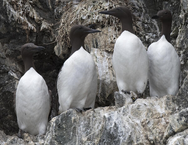
Skinny Common Murre with keel protruding (second from the left)
Skinny Common Murre with keel protruding (second from the left) contrasted by normal murres. Lower Cook Inlet, Alaska.
Skinny Common Murre with keel protruding (second from the left) contrasted by normal murres. Lower Cook Inlet, Alaska.

Tree Growth - soil acidified by acid rain
Peggy Phillips measures a young red maple in an Adirondack watershed to see if liming has improved tree growth in a watershed where acid rain severely acidified the soil.
Peggy Phillips measures a young red maple in an Adirondack watershed to see if liming has improved tree growth in a watershed where acid rain severely acidified the soil.

UAS pilots in the field
Woods Hole Coastal and Marine Science Center unmanned aerial systems (uas) pilots conduct drone flights at Sandy Neck Beach, Cape Cod, MA
Woods Hole Coastal and Marine Science Center unmanned aerial systems (uas) pilots conduct drone flights at Sandy Neck Beach, Cape Cod, MA

Aftershocks of the 2018 magnitude-6.9 earthquake expected to continue
The inferred rupture area (white dashed line) of the May 4, 2018, magnitude-6.9 earthquake, with its foreshocks and first 10 days of aftershocks, spans an area of about 800 sq km (300 sq mi). Circle size indicates earthquake magnitude; color indicates earthquake depth. Magnitudes for some of the larger events are labeled.
The inferred rupture area (white dashed line) of the May 4, 2018, magnitude-6.9 earthquake, with its foreshocks and first 10 days of aftershocks, spans an area of about 800 sq km (300 sq mi). Circle size indicates earthquake magnitude; color indicates earthquake depth. Magnitudes for some of the larger events are labeled.

Fishing Cone, West Thumb
Fishing cone, a hot springs on the floor of Yellowstone Lake. The hot spring rim sits at lake level.
Fishing cone, a hot springs on the floor of Yellowstone Lake. The hot spring rim sits at lake level.

GPS station P361, on Sawtell Peak
GPS station P361, on Sawtell Peak, on a nice clear day. Electrical storms destroyed multiple antennas, including the GPS antenna--here under a protective plastic dome--and three communications antennas on the tower. Data from P361, along with data from other stations in the Yellowstone region, are sent to UNAVCO for free and open distribution.
GPS station P361, on Sawtell Peak, on a nice clear day. Electrical storms destroyed multiple antennas, including the GPS antenna--here under a protective plastic dome--and three communications antennas on the tower. Data from P361, along with data from other stations in the Yellowstone region, are sent to UNAVCO for free and open distribution.

Mount Baker and Glacier Peak - Active Volcanoes
Are you ready for an eruption? Mount Baker dominates the skyline of northwestern Washington and southwestern British Columbia. Glacier Peak is mostly hidden from view. Both volcanoes have erupted in recent centuries and will erupt again, disrupting the landscape and the lives of people downstream and downwind. Learn what to do and where to get information.
Are you ready for an eruption? Mount Baker dominates the skyline of northwestern Washington and southwestern British Columbia. Glacier Peak is mostly hidden from view. Both volcanoes have erupted in recent centuries and will erupt again, disrupting the landscape and the lives of people downstream and downwind. Learn what to do and where to get information.

Mount Rainier is an active volcano. Are you Ready for an Eruption?
Mount Rainier is much more than a mountain in the sky. Constructed of hundreds of lava flows, and capped by as much glacier ice as all other Cascade volcanoes combined, Rainier's steep rubbly slopes and abundant water make it prone to landslides and lahars, especially during eruptions. Are you ready for an eruption?
Mount Rainier is much more than a mountain in the sky. Constructed of hundreds of lava flows, and capped by as much glacier ice as all other Cascade volcanoes combined, Rainier's steep rubbly slopes and abundant water make it prone to landslides and lahars, especially during eruptions. Are you ready for an eruption?

UNAVCO field engineer Dylan Cembalski replaces damaged antennas on the communica
UNAVCO field engineer Dylan Cembalski replaces damaged antennas on the communications tower at Sawtell Peak. The tower is shared by multiple groups that use this regional high point to relay data. (UNAVCO Photo by Summer Rhoades)
UNAVCO field engineer Dylan Cembalski replaces damaged antennas on the communications tower at Sawtell Peak. The tower is shared by multiple groups that use this regional high point to relay data. (UNAVCO Photo by Summer Rhoades)

Viscous lava hits ocean water
A viscous pāhoehoe flow from Kilauea Volcano, Hawaiʻi , entering the ocean near Isaac Hale Beach Park on the morning of August 5, 2018.
A viscous pāhoehoe flow from Kilauea Volcano, Hawaiʻi , entering the ocean near Isaac Hale Beach Park on the morning of August 5, 2018.

Volcano collapses mark the beginning and end of USGS scientist's career
Left: Horseshoe-shaped crater of Mount St. Helens in 1980, formed by a landslide that removed the top of the volcano. The crater is about 2 km (1.2 mi) wide and the floor is about 600 m (1,970 ft) below the crater rim. Right: Halema'uma'u nestled in the summit crater of Kīlauea Volcano on August 1, the day before the last collapse event.
Left: Horseshoe-shaped crater of Mount St. Helens in 1980, formed by a landslide that removed the top of the volcano. The crater is about 2 km (1.2 mi) wide and the floor is about 600 m (1,970 ft) below the crater rim. Right: Halema'uma'u nestled in the summit crater of Kīlauea Volcano on August 1, the day before the last collapse event.

Before and after satellite images of Leilani Estates subdivision
This comparison shows satellite images of Leilani Estates subdivision before and after the May-August 2018 eruption. The image on the right, collected in early September 2018, shows that the eastern portion of the subdivision has been covered by lava. The Fissure 8 lava channel runs northeast, with the Fissure 8 cone at the start of the channel.
This comparison shows satellite images of Leilani Estates subdivision before and after the May-August 2018 eruption. The image on the right, collected in early September 2018, shows that the eastern portion of the subdivision has been covered by lava. The Fissure 8 lava channel runs northeast, with the Fissure 8 cone at the start of the channel.