
Is this cemetery haunted? Probably not, but there could be tiny things moving beyond the grave. The USGS sampled groundwater downhill of Mt. Hope Cemetery in Lansing, Michigan, to find out if materials associated with decomposition and burial processes could affect groundwater quality near a cemetery.
Images
Explore our planet through photography and imagery, including climate change and water all the way back to the 1800s when the USGS was surveying the country by horse and buggy.
Filter Total Items: 21545

Groundwater Sampling at Mt. Hope Cemetery, Michigan
Is this cemetery haunted? Probably not, but there could be tiny things moving beyond the grave. The USGS sampled groundwater downhill of Mt. Hope Cemetery in Lansing, Michigan, to find out if materials associated with decomposition and burial processes could affect groundwater quality near a cemetery.
Is this cemetery haunted? Probably not, but there could be tiny things moving beyond the grave. The USGS sampled groundwater downhill of Mt. Hope Cemetery in Lansing, Michigan, to find out if materials associated with decomposition and burial processes could affect groundwater quality near a cemetery.

Groundwater sampling equipment at AY-68-27-610 (Parkwood Park).
Back cover photo from

Hampton Roads Benchmark Monitoring: Occupying a Benchmark
Hampton Roads Benchmark Monitoring: Occupying a Benchmark
Hampton Roads Benchmark Monitoring: Occupying a Benchmark

Hawaiian green sea turtle, Chelonia mydas
Hawaiian green sea turtle, Chelonia mydas
Hawaiian green sea turtle, Chelonia mydas

Healthy elkhorn coral on the seafloor in the U.S. Virgin Islands
Healthy elkhorn coral (Acropora palmata) on the seafloor along the southeastern coast of Buck Island, U.S. Virgin Islands. Elkhorn coral is one of many important reef-building species that create 3D structure on the seafloor. Coral reef structure provides habitat for marine life and helps break up waves as they approach the coastline.
Healthy elkhorn coral (Acropora palmata) on the seafloor along the southeastern coast of Buck Island, U.S. Virgin Islands. Elkhorn coral is one of many important reef-building species that create 3D structure on the seafloor. Coral reef structure provides habitat for marine life and helps break up waves as they approach the coastline.

Helicopter Lifting Off to Start a Data Collection Run for EM Data
Helicopter lifting off to start a data collection run.
Helicopter lifting off to start a data collection run.

Helotes flood
Page 67 photo from
Page 67 photo from

Hibernating little brown bat
A little brown bat (Myotis lucifugus) with white-nose syndrome hibernating in a Virginia cave during late spring of 2016.
A little brown bat (Myotis lucifugus) with white-nose syndrome hibernating in a Virginia cave during late spring of 2016.
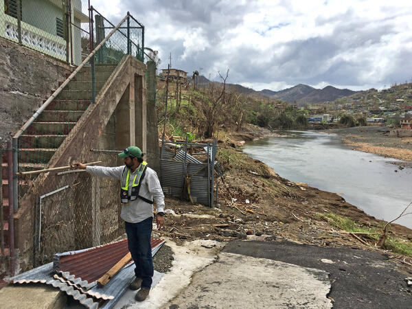
Hurricane Maria high-water mark
CAPTION: José Santiago-Saez, USGS hydrologic technician, flags a high-water mark in Comerio, Puerto Rico, from flooding on the Río de la Plata caused by Hurricane Maria. USGS Photo.
CAPTION: José Santiago-Saez, USGS hydrologic technician, flags a high-water mark in Comerio, Puerto Rico, from flooding on the Río de la Plata caused by Hurricane Maria. USGS Photo.

Hydrogeophysics Branch -- Storrs, Connecticut
Hydrogeophysics Branch -- Storrs, Connecticut
Hydrogeophysics Branch -- Storrs, Connecticut

Hydrotherm program output example
Example Hydrotherm output. Hydrotherm is a three-dimensional simulation of multiphase groundwater flow and heat transport in the temperature range of 0 to 1200 degrees Celsius and the pressure range of 1 to 1000 MPa.
Example Hydrotherm output. Hydrotherm is a three-dimensional simulation of multiphase groundwater flow and heat transport in the temperature range of 0 to 1200 degrees Celsius and the pressure range of 1 to 1000 MPa.

Image from a remote camera placed in a golden eagle nest in the Mojave
Image from a remote camera placed in a golden eagle nest in the Mojave Desert. The parent is feed the chick a snake.
Image from a remote camera placed in a golden eagle nest in the Mojave Desert. The parent is feed the chick a snake.

Images of Madeira Beach, Florida, from video taken June 20, 2017
Views of Madeira Beach, Florida, produced from a 17-minute video shot on June 20, 2017. Left: Snapshot, or first frame of video. Right: Time-averaged image, sometimes called a “timex,” created by averaging the intensity of light recorded at each spot, or “pixel,” during the 17-minute video.
Views of Madeira Beach, Florida, produced from a 17-minute video shot on June 20, 2017. Left: Snapshot, or first frame of video. Right: Time-averaged image, sometimes called a “timex,” created by averaging the intensity of light recorded at each spot, or “pixel,” during the 17-minute video.

IMMeRSS Cruise expedition area
Map of the general expedition area on the northern U.S. Atlantic Margin between Baltimore Canyon and Cape Hatteras
Map of the general expedition area on the northern U.S. Atlantic Margin between Baltimore Canyon and Cape Hatteras

Installing large boulders to armor the shore against further erosion
Installing large boulders as riprap to armor the shore against further erosion at Goleta Beach in Southern California. The tide is very low (negative).
Installing large boulders as riprap to armor the shore against further erosion at Goleta Beach in Southern California. The tide is very low (negative).

Invasive Annual Grass Fills the Space Between Shrubs, Mojave
An unburned low elevation community in the central Mojave where the interspaces between shrubs have been filled in with a continuous layer of Mediterranean split grass Schismus barbatus. If a fire started here it would spread much more rapidly and be far more extensive than in a low elevation community where the interspaces are rocky or bare.
An unburned low elevation community in the central Mojave where the interspaces between shrubs have been filled in with a continuous layer of Mediterranean split grass Schismus barbatus. If a fire started here it would spread much more rapidly and be far more extensive than in a low elevation community where the interspaces are rocky or bare.

Lake Powell
The USGS Utah Water Science Center and the Woods Hole Coastal and Marine Science Center conducted a collaborative geophysical research effort within Lake Powell, UT-AZ to map the bathymetry of the lake and characterize shallow sediment deposition near the mouths of the San Juan and Colorado Rivers.
The USGS Utah Water Science Center and the Woods Hole Coastal and Marine Science Center conducted a collaborative geophysical research effort within Lake Powell, UT-AZ to map the bathymetry of the lake and characterize shallow sediment deposition near the mouths of the San Juan and Colorado Rivers.

Leetown Science Center and Patuxent Wildlife Research Center building
Leetown Science Center and Patuxent Wildlife Research Center building
Leetown Science Center and Patuxent Wildlife Research Center building

Lidar point cloud of Rio Grande River
Lidar point cloud of Rio Grande River- El Paso, TX
Lidar point cloud of Rio Grande River- El Paso, TX