
Dr. Brian Halstead, USGS WERC, gestures to the Randall House, now abandoned, constructed in the early 20th century. The house is now maintained by the National Park Service as a maternity roost for Townsend's Big-Eared bats.
Images
Explore our planet through photography and imagery, including climate change and water all the way back to the 1800s when the USGS was surveying the country by horse and buggy.
Filter Total Items: 21545

Brian Halstead with Bat Maternity Roost
Dr. Brian Halstead, USGS WERC, gestures to the Randall House, now abandoned, constructed in the early 20th century. The house is now maintained by the National Park Service as a maternity roost for Townsend's Big-Eared bats.

Driftwood and Dunes - Point Reyes
Photo of driftwood, and invasive grasses and iceplant at Point Reyes National Seashore, CA. Such "dune drainages" make surprising habitat for a threatened species of amphibian: the California red-legged frog.
Photo of driftwood, and invasive grasses and iceplant at Point Reyes National Seashore, CA. Such "dune drainages" make surprising habitat for a threatened species of amphibian: the California red-legged frog.

Drone carrying a precision GPS and special camera to map the shore
Josh Logan operates a drone carrying a precision GPS and special camera to map the shore at Long Beach, Washington. USGS scientists used the same system for detailed mapping of beaches beside Monterey Bay, California.
Josh Logan operates a drone carrying a precision GPS and special camera to map the shore at Long Beach, Washington. USGS scientists used the same system for detailed mapping of beaches beside Monterey Bay, California.

Large Driftwood and Dunes at Point Reyes
Driftwood and sand dunes at the Point Reyes National Seashore.
Driftwood and sand dunes at the Point Reyes National Seashore.

Pat Kleeman Searches for CA Red-Legged Frogs
Pat Kleeman, USGS WERC, searches for threatened California red-legged frogs in a dune drainage, Point Reyes National Seashore.
Pat Kleeman, USGS WERC, searches for threatened California red-legged frogs in a dune drainage, Point Reyes National Seashore.

The catch from a fyke net set near Kaktovik, Alaska
Biologists identify species, count, measure length, and release thousands of fish each year to understand how fish use nearshore habitats.
Biologists identify species, count, measure length, and release thousands of fish each year to understand how fish use nearshore habitats.

Trees at Point Reyes National Seashore
Dead trees like the ones featured in this photo still provide valuable habitat for wildlife, including birds.
Dead trees like the ones featured in this photo still provide valuable habitat for wildlife, including birds.

A fyke net set to catch nearshore fish near Kaktovik, Alaska
A fyke net or fish trap used for continuous sampling of nearshore fish in shallow waters. Fish swimming along the beach are stopped by a small-mesh net that guides them in to one of these two underwater fish traps that are set side by side. Researchers visit nets at least once a day to identify, count, and release fish.
A fyke net or fish trap used for continuous sampling of nearshore fish in shallow waters. Fish swimming along the beach are stopped by a small-mesh net that guides them in to one of these two underwater fish traps that are set side by side. Researchers visit nets at least once a day to identify, count, and release fish.

A World of Hops
The world's largest continuous hops-growing region by area is Hallertau, just north of Munich. More than 80 percent of Germany's hops come from this 42,000-acre stretch of fertile loess soil.
The world's largest continuous hops-growing region by area is Hallertau, just north of Munich. More than 80 percent of Germany's hops come from this 42,000-acre stretch of fertile loess soil.

Underwater image of fish captured by a fyke net
An underwater image of fish captured by a fyke net near Kaktovik, Alaska, Beaufort Sea, USA. The small silver fish with dark backs are young-of-year (age-0) Arctic cisco (Coregonus autumnalis) and the flatfish are Arctic flounder (Liopsetta glacialis).
An underwater image of fish captured by a fyke net near Kaktovik, Alaska, Beaufort Sea, USA. The small silver fish with dark backs are young-of-year (age-0) Arctic cisco (Coregonus autumnalis) and the flatfish are Arctic flounder (Liopsetta glacialis).

USGS, Las Cruces Field Office
U.S. Geological Survey, New Mexico Water Science Center - Las Cruces Field Office location
U.S. Geological Survey, New Mexico Water Science Center - Las Cruces Field Office location

Continuous water-quality monitor
Photograph showing a continuous water-quality monitor at the Salmon River near East Hampton, Connecticut.
Photograph showing a continuous water-quality monitor at the Salmon River near East Hampton, Connecticut.

What was happening at Kīlauea ten years ago?
This perched lava channel, which was as much as 150 feet (45 meters) above the ground, carried lava downslope from the Pu‘u ‘Ō‘ō Fissure D vent during episode 58 of Kīlauea Volcano's ongoing East Rift Zone eruption. The channel was the main path for lava between July and November 2007. Episode 58 continued until early March 2011.
This perched lava channel, which was as much as 150 feet (45 meters) above the ground, carried lava downslope from the Pu‘u ‘Ō‘ō Fissure D vent during episode 58 of Kīlauea Volcano's ongoing East Rift Zone eruption. The channel was the main path for lava between July and November 2007. Episode 58 continued until early March 2011.

Charcoal collected from under the base of a pāhoehoe flow, Hawaii
Charcoal collected from under the base of a pāhoehoe flow in a black sooty zone over orange ash. The black sooty zone represents the region where the vegetation was converted to charcoal. The hammer is approximately 13 inches long. USGS photo by F. Trusdell.
Charcoal collected from under the base of a pāhoehoe flow in a black sooty zone over orange ash. The black sooty zone represents the region where the vegetation was converted to charcoal. The hammer is approximately 13 inches long. USGS photo by F. Trusdell.

Cyanobacteria - Scytonema (blue green algae)
Microscopic view of blue green algae sample. Some algae produce toxins that threaten the health and safety of living things that come in direct contact. Cyanobacteria - Scytonema (blue green algae)
Microscopic view of blue green algae sample. Some algae produce toxins that threaten the health and safety of living things that come in direct contact. Cyanobacteria - Scytonema (blue green algae)

GeoGirls_Sediment1
GeoGirls collect water samples and flow measurements to model the transport of volcanic sediments.
GeoGirls collect water samples and flow measurements to model the transport of volcanic sediments.
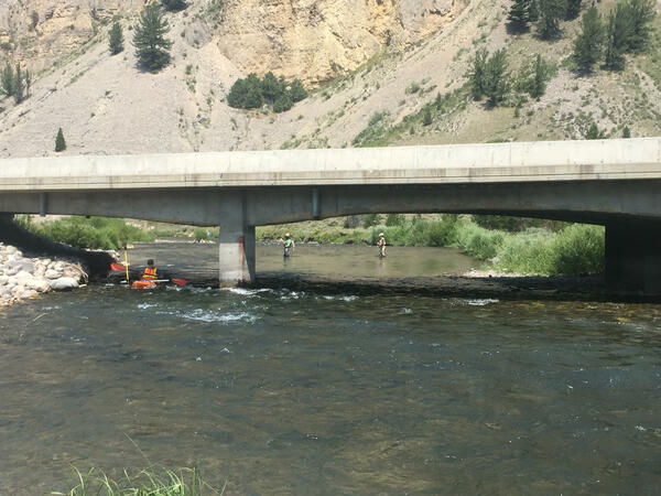
Measuring cross-sectional depth and water surface of Gallatin River
Using kayak to measure cross-sectional depth and water surface of Gallatin River
Using kayak to measure cross-sectional depth and water surface of Gallatin River

A glimpse of the microbial world's hidden beauty
To collect, identify and document these single-celled algae called desmids, USGS biologist Barry H. Rosen has traveled by airboat into the interior of Florida’s Loxahatchee National Wildlife Refuge, where decaying marsh grasses created a mosaic of peat soils and the soft, slightly acidic water where desmids grow.
To collect, identify and document these single-celled algae called desmids, USGS biologist Barry H. Rosen has traveled by airboat into the interior of Florida’s Loxahatchee National Wildlife Refuge, where decaying marsh grasses created a mosaic of peat soils and the soft, slightly acidic water where desmids grow.

A natural marvel in a single cell
This single-celled freshwater algae wasa collected as part of the first-ever study of the green algae family called desmids in Florida’s Loxahatchee National Wildlife Refuge, in the northern Everglades. USGS biologist Barry H.
This single-celled freshwater algae wasa collected as part of the first-ever study of the green algae family called desmids in Florida’s Loxahatchee National Wildlife Refuge, in the northern Everglades. USGS biologist Barry H.

Akilik River stream sampling
Hiking up a stream from the Akilik River drainage to set minnow traps for fish sampling. This is a stream type at the Boreal-Arctic transition of the Brooks Range, Noatak National Park and Preserve, Kobuk Valley National Park.
Hiking up a stream from the Akilik River drainage to set minnow traps for fish sampling. This is a stream type at the Boreal-Arctic transition of the Brooks Range, Noatak National Park and Preserve, Kobuk Valley National Park.

Beaufort Sea coastline on Arey Island with eroding cliff near Kaktovik
Eroding coastline of the Beaufort Sea on Arey Island near Kaktovik.
Eroding coastline of the Beaufort Sea on Arey Island near Kaktovik.