
Preview image for video: A rockfall on the east rim of the summit vent within Kīlauea Volcano's Halema‘uma‘u Crater triggered a small explosive event at 3:51 a.m., HST, on January 8, 2016. Explosive events like this occur more frequently when the lava lake level is relatively high, as it has been this past week—around 30-35 m (100-115 ft) below the vent rim.
Images
Explore our planet through photography and imagery, including climate change and water all the way back to the 1800s when the USGS was surveying the country by horse and buggy.
Filter Total Items: 21545

Early morning explosive event at Kīlauea summit lava lake
Preview image for video: A rockfall on the east rim of the summit vent within Kīlauea Volcano's Halema‘uma‘u Crater triggered a small explosive event at 3:51 a.m., HST, on January 8, 2016. Explosive events like this occur more frequently when the lava lake level is relatively high, as it has been this past week—around 30-35 m (100-115 ft) below the vent rim.

Santa Cruz coastal erosion
The coastal bluff along East Cliff Drive in Santa Cruz, California are especially vulnerable to rising sea level during big storms. Sometimes even the rip-rap, put in place to protect roadways and homes, cannot protect the bluffs from erosion.
The coastal bluff along East Cliff Drive in Santa Cruz, California are especially vulnerable to rising sea level during big storms. Sometimes even the rip-rap, put in place to protect roadways and homes, cannot protect the bluffs from erosion.
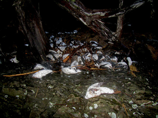
Thousands of Common Murre carcasses on beaches in Pigot Bay
Thousands of Common Murre carcasses piled up on beaches in Pigot Bay following the massive die-off of murres in 2015/2016.
Thousands of Common Murre carcasses piled up on beaches in Pigot Bay following the massive die-off of murres in 2015/2016.

Underwater view of periphyton on rocks and the Lake Tahoe shoreline
Underwater view of periphyton on rocks and the Lake Tahoe shoreline.
Underwater view of periphyton on rocks and the Lake Tahoe shoreline.

USGS Streamgage at Baton Rouge
The USGS Streamgage at Baton Rouge, Louisiana, during the 2015/2016 Mississippi River Valley Flooding.
The USGS Streamgage at Baton Rouge, Louisiana, during the 2015/2016 Mississippi River Valley Flooding.
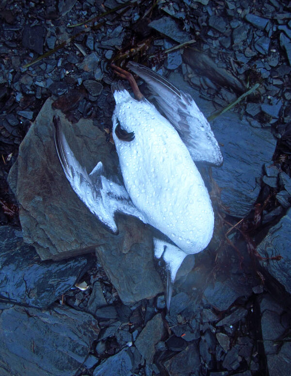
A dead Common Murre found on the beach in Prince William Sound
A dead Common Murre found on the beach in Prince William Sound on Jan 7, 2016. This bird was part of the large die-off of Common Murres across the Gulf of Alaska in 2015-2016.
A dead Common Murre found on the beach in Prince William Sound on Jan 7, 2016. This bird was part of the large die-off of Common Murres across the Gulf of Alaska in 2015-2016.

Flooded Coastal Road Santa Cruz County California
Waves flood across a coastal road near Santa Cruz, California.
Waves flood across a coastal road near Santa Cruz, California.

Santa Cruz, California's Main Beach in winter
View of the Santa Cruz Beach Boardwalk amusement park in Santa Cruz, California. Photo was taken from the bluff on East Cliff Drive, east of the San Lorenzo River mouth. Sand on the beach gets eroded, redistributed, and deposited due to the dynamic conditions brought about by storms and changing river flow.
View of the Santa Cruz Beach Boardwalk amusement park in Santa Cruz, California. Photo was taken from the bluff on East Cliff Drive, east of the San Lorenzo River mouth. Sand on the beach gets eroded, redistributed, and deposited due to the dynamic conditions brought about by storms and changing river flow.

Bookshelves at USGS Library in Denver
USGS Library locations offer collections and services to USGS staff and public researchers.
By
USGS Library locations offer collections and services to USGS staff and public researchers.
By

El Niño Hits San Diego
Sections of Fashion Valley Road, San Diego, were closed by flooding of the San Diego River. Closed roads were a common scene in San Diego and throughout California during the El Niño-related storms, Jan 6 - 7, 2016. Hydrographers from the Poway Field Office closely monitored high-flow conditions throughout the storms.
Sections of Fashion Valley Road, San Diego, were closed by flooding of the San Diego River. Closed roads were a common scene in San Diego and throughout California during the El Niño-related storms, Jan 6 - 7, 2016. Hydrographers from the Poway Field Office closely monitored high-flow conditions throughout the storms.

High Water Measurements at USGS Site 11059300
Jon Newby and Travis Kordiak, USGS Hydrographers from the California Water Science Center Redlands Field Office, take high-water measurements at USGS streamgaging site 11059300. The site is on the Santa Ana River in San Bernardino, California, and is one of more than 500 streamgage locations in California.
Jon Newby and Travis Kordiak, USGS Hydrographers from the California Water Science Center Redlands Field Office, take high-water measurements at USGS streamgaging site 11059300. The site is on the Santa Ana River in San Bernardino, California, and is one of more than 500 streamgage locations in California.

Wabash River at New Harmony IN - 2016 flooding
Wabash River at New Harmony IN - 2016 flooding
Wabash River at New Harmony IN - 2016 flooding

Another small explosive event at Kīlauea's summit lava lake
On January 4, a rockfall within the Overlook vent at the summit of Kīlauea generated another small explosive event at 3:18 a.m., HST. In this image, captured by a USGS Hawaiian Volcano Observatory webcam, the dusty gas plume can be seen rising from the vent after rocks impacted the lava lake.
On January 4, a rockfall within the Overlook vent at the summit of Kīlauea generated another small explosive event at 3:18 a.m., HST. In this image, captured by a USGS Hawaiian Volcano Observatory webcam, the dusty gas plume can be seen rising from the vent after rocks impacted the lava lake.

Close up photo of synthetic surrogate eggs in water
Synthetic surrogate water-hardened Silver Carp Eggs settled on top of a sediment bed. Laboratory experiments in flowing water demonstrate egg suspension at lower velocities than previously thought.
Synthetic surrogate water-hardened Silver Carp Eggs settled on top of a sediment bed. Laboratory experiments in flowing water demonstrate egg suspension at lower velocities than previously thought.

In of Kīlauea's summit lava lake, the light-colored rock in the ven...
In this photo of Kīlauea Volcano's summit lava lake, the light-colored rock in the vent wall to the left of the spattering lava shows were a rockfall occurred on January 2. The shadow of the gas plume appears as a brown streak perpendicular to the dark-colored lava on the floor of Halema‘uma‘u Crater.
In this photo of Kīlauea Volcano's summit lava lake, the light-colored rock in the vent wall to the left of the spattering lava shows were a rockfall occurred on January 2. The shadow of the gas plume appears as a brown streak perpendicular to the dark-colored lava on the floor of Halema‘uma‘u Crater.

USGS hydrologic technician collecting streamflow data
USGS hydrologic technician Deena Green collects streamflow data at streamgage station 12413875, St. Joe River at Red Ives Ranger Station, Idaho
USGS hydrologic technician Deena Green collects streamflow data at streamgage station 12413875, St. Joe River at Red Ives Ranger Station, Idaho

Collecting a groundwater-level measurement in Freeport, Texas
USGS hydrologist Jason Ramage collects a groundwater-level measurement using a steel tape in Freeport, Texas.
A new interactive web application illustrates how groundwater, sediment compaction and land-elevation change are related in the Houston-Galveston region in Texas.
USGS hydrologist Jason Ramage collects a groundwater-level measurement using a steel tape in Freeport, Texas.
A new interactive web application illustrates how groundwater, sediment compaction and land-elevation change are related in the Houston-Galveston region in Texas.

Drilling into permafrost on Alaska's Arctic coast
On remote Barter Island, Alaska, Bruce Richmond (right) and Cordell Johnson drill into 500-foot-thick permafrost using a handheld drill with a 2-inch drill bit—a challenging task! It can take 3 hours to drill nearly 20 feet down.
On remote Barter Island, Alaska, Bruce Richmond (right) and Cordell Johnson drill into 500-foot-thick permafrost using a handheld drill with a 2-inch drill bit—a challenging task! It can take 3 hours to drill nearly 20 feet down.

Graphic of Williston Basin Oil and Gas Wells
This is a graphic showing the boundary of the Williston Basin Province and Oil and Gas Wells, North Dakota, South Dakota and Eastern Montana, 2016
This is a graphic showing the boundary of the Williston Basin Province and Oil and Gas Wells, North Dakota, South Dakota and Eastern Montana, 2016

Iiwi on Mamane
The Hawaiian ‘I‘iwi, a native forest bird species only found in the Hawaiian Islands.
The Hawaiian ‘I‘iwi, a native forest bird species only found in the Hawaiian Islands.

North Atlantic Landscape Conservation Cooperative region
Coastal area within the North Atlantic Landscape Conservation Cooperative region for which predictions have been generated.
Coastal area within the North Atlantic Landscape Conservation Cooperative region for which predictions have been generated.