
Variously shaped fields of crops decorate the rich Canterbury Plains on New Zealand's South Island. This 2015 Landsat image shows the farmland abutting the Waimakariri River that winds down toward the city of Christchurch and ultimately the Pacific Ocean.
Images
Explore our planet through photography and imagery, including climate change and water all the way back to the 1800s when the USGS was surveying the country by horse and buggy.
Filter Total Items: 21545

Landsat image shows agricultural development, Canterbury, NZ
Variously shaped fields of crops decorate the rich Canterbury Plains on New Zealand's South Island. This 2015 Landsat image shows the farmland abutting the Waimakariri River that winds down toward the city of Christchurch and ultimately the Pacific Ocean.

Learning water quality methods: calibrating a water quality sodne
Learning water quality methods: Sequoya Bua-Iam (2015) calibrates a sonde in the USGS laboratory.
Learning water quality methods: Sequoya Bua-Iam (2015) calibrates a sonde in the USGS laboratory.

Learning water quality methods: recording a water quality sonde
Learning water quality methods: Sequoya Bua-Iam (2015) records a sonde in the USGS laboratory.
Learning water quality methods: Sequoya Bua-Iam (2015) records a sonde in the USGS laboratory.

Lights! Camera! Action!
Dr. Laura Brothers preparing to collect visual imagery aboard the RV Rafael as part of the launch of the MiniSEABOSS while doing work off of Nantucket. The MiniSEABOSS collects samples, photos and video of the seafloor.
Dr. Laura Brothers preparing to collect visual imagery aboard the RV Rafael as part of the launch of the MiniSEABOSS while doing work off of Nantucket. The MiniSEABOSS collects samples, photos and video of the seafloor.

Map of daily-averaged ocean surface current data
Map of daily-averaged ocean surface current data integrated from multiple IOOS Partner forecast models
Map of daily-averaged ocean surface current data integrated from multiple IOOS Partner forecast models

Map of distribution of substrate mud content, Stellwagen Bank
Map of distribution of substrate mud content, Stellwagen Bank
Map of distribution of substrate mud content, Stellwagen Bank

Maps showing (A) acoustic backscatter and (B) bathymetry
Maps showing (A) acoustic backscatter and (B) bathymetry collected with the inteferomentric sonar
Maps showing (A) acoustic backscatter and (B) bathymetry collected with the inteferomentric sonar

Measuring index properties on sediment samples
Junbong Jang of the USGS Woods Hole Coastal and Marine Science Center measures index properties on sediment collected during the Indian Government’s National Gas Hydrates Program (NGHP-02) drilling expedition offshore from eastern India in the summer of 2015.
Junbong Jang of the USGS Woods Hole Coastal and Marine Science Center measures index properties on sediment collected during the Indian Government’s National Gas Hydrates Program (NGHP-02) drilling expedition offshore from eastern India in the summer of 2015.

Microscopic Gold and Lead Particles
Microscopic gold and lead particles surrounded by organic and phosphorus-rich material in a municipal biosolids sample (combined surface topography and atomic weight images).
Microscopic gold and lead particles surrounded by organic and phosphorus-rich material in a municipal biosolids sample (combined surface topography and atomic weight images).
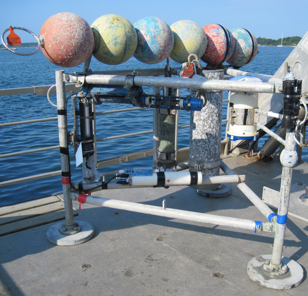
Minipod style tripod for near bottom current and wave measurements
Minipod style tripod for near bottom current and wave measurements ready for deployment.
Minipod style tripod for near bottom current and wave measurements ready for deployment.

Monarchs
The Eastern, migratory population of monarch butterflies has declined by about 80 percent over the last decade.
The Eastern, migratory population of monarch butterflies has declined by about 80 percent over the last decade.

Mongolian Hydrologist Showing a Monitoring Site
A Mongolian hydrologist showed a monitoring site where groundwater levels, precipitation, air temperature, soil moisture, and soil temperature data are collected. More information on this study is available at https://doi.org/10.3133/ofr20161096.
A Mongolian hydrologist showed a monitoring site where groundwater levels, precipitation, air temperature, soil moisture, and soil temperature data are collected. More information on this study is available at https://doi.org/10.3133/ofr20161096.

Monitoring Seismicity in the Long Valley
CalVO's Stuart Wilkinson skis out to a remote seismic instrument in the Long Valley volcanic region to perform routine maintenance.
CalVO's Stuart Wilkinson skis out to a remote seismic instrument in the Long Valley volcanic region to perform routine maintenance.

New Croton Dam is part of New York City's water supply system
The New Croton Dam is part of New York City's water supply system, Croton-on-Hudson, Westchester County, New York.
The New Croton Dam is part of New York City's water supply system, Croton-on-Hudson, Westchester County, New York.

Ocean sand in wetland core
A vibracore taken from a marshy area in Anahola Valley, Kaua‛i reveals a sandier mud layer.
A vibracore taken from a marshy area in Anahola Valley, Kaua‛i reveals a sandier mud layer.

Oil Well being Drilled into the Bakken Formation
Oil well being drilled into the Bakken Formation in North Dakota in 2015.
Oil well being drilled into the Bakken Formation in North Dakota in 2015.
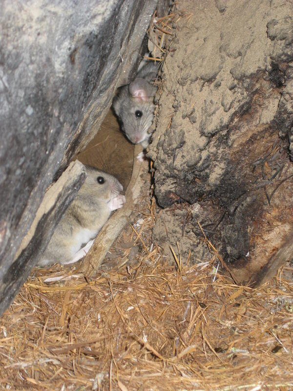
Packrats and Their Midden
Packrats near their midden in the City of Rocks National Reserve. USGS Image (J. Betancourt).
Packrats near their midden in the City of Rocks National Reserve. USGS Image (J. Betancourt).

Pallid Sturgeon
The pallid sturgeon is an endangered riverine sturgeon with historical distribution restricted to parts of the Yellowstone, Missouri, Mississippi, and Atchafalaya Rivers. Although rare, pallid sturgeon in the lower Mississippi River appear to be naturally recruiting, and information about habitat use is important to conserve this species.
The pallid sturgeon is an endangered riverine sturgeon with historical distribution restricted to parts of the Yellowstone, Missouri, Mississippi, and Atchafalaya Rivers. Although rare, pallid sturgeon in the lower Mississippi River appear to be naturally recruiting, and information about habitat use is important to conserve this species.

Pallid Sturgeon
An adult pallid sturgeon, an endangered species.
An adult pallid sturgeon, an endangered species.

Permafrost Loss Dramatically Changes Yukon River Chemistry and Hydrolo
Yukon River freezing up at Pilot Station, AK
Yukon River freezing up at Pilot Station, AK

Photo collage of researchers on personal watercraft at Fire Island
Personal watercraft were utilized to collect bathymetry in the surf zone and shore face (top left), setup on the beach (top right), instrument configuration (bottom left) and Pelican case hardware configuration (bottom right).
Personal watercraft were utilized to collect bathymetry in the surf zone and shore face (top left), setup on the beach (top right), instrument configuration (bottom left) and Pelican case hardware configuration (bottom right).