
Sandy Brosnahan transporting a weather buoy into the Woods Hole Coastal and Marine Science Center’s operational facility in preparation for deployment. This buoy was one of 6 deployed to measure wind speed, direction, pressure, and temperature off the coast of Fire Island, NY.
Images
Explore our planet through photography and imagery, including climate change and water all the way back to the 1800s when the USGS was surveying the country by horse and buggy.
Filter Total Items: 21545

Special Delivery
Sandy Brosnahan transporting a weather buoy into the Woods Hole Coastal and Marine Science Center’s operational facility in preparation for deployment. This buoy was one of 6 deployed to measure wind speed, direction, pressure, and temperature off the coast of Fire Island, NY.

Strong River at D'Lo Mississippi
This image was taken at the Strong River at D'Lo, Mississippi by Shane Stocks who is a Hydrologic Technician out of the Jackson, MS office. Shane used an infared camera to take this long exposure shot of the river.
This image was taken at the Strong River at D'Lo, Mississippi by Shane Stocks who is a Hydrologic Technician out of the Jackson, MS office. Shane used an infared camera to take this long exposure shot of the river.

The Southern High Plains
The Southern High Plains of New Mexico, Oklahoma, and Texas. USGS conducted a uranium assessment in this region in 2015.
The Southern High Plains of New Mexico, Oklahoma, and Texas. USGS conducted a uranium assessment in this region in 2015.

The Southern High Plains
The Southern High Plains of New Mexico, Oklahoma, and Texas. USGS conducted a uranium assessment in this region in 2015.
The Southern High Plains of New Mexico, Oklahoma, and Texas. USGS conducted a uranium assessment in this region in 2015.

Thompson getting ready for take off to visit caribou cratering areas
Thompson getting ready for take off to visit caribou cratering areas (areas where caribou dig for lichens in the winter time).
Thompson getting ready for take off to visit caribou cratering areas (areas where caribou dig for lichens in the winter time).

Thompson working on ice training, Ontario, Canada
Thompson working on ice training, Ontario, Canada.
Thompson working on ice training, Ontario, Canada.

Trail Near Blue Ridge Parkway Near Afton, Virginia
Trail Near Blue Ridge Parkway Near Afton, Virginia
Trail Near Blue Ridge Parkway Near Afton, Virginia

Tsunami Evacuation Sign
Tsunami evacuation route sign at an intersection in Nehalem, Oregon.
Tsunami evacuation route sign at an intersection in Nehalem, Oregon.

U.S. Geological Survey (USGS) Scientists Processing Leachate Samples
U.S. Geological Survey (USGS) scientists processing leachate samples collected for a national-scale study on the occurrence of contaminants of emerging concern (CECs) in landfill leachate disposed offsite.
U.S. Geological Survey (USGS) scientists processing leachate samples collected for a national-scale study on the occurrence of contaminants of emerging concern (CECs) in landfill leachate disposed offsite.

U.S. maps of atrazine use and predicted concentrations in groundwater
Atrazine use (left) (left) is one of the most important factors used to predict atrazine and deethylatrazine concentrations in
Atrazine use (left) (left) is one of the most important factors used to predict atrazine and deethylatrazine concentrations in

UAV launch
USGS scientist Todd Preston launches a UAV in Montana to study potential application for wildlife monitoring.
USGS scientist Todd Preston launches a UAV in Montana to study potential application for wildlife monitoring.

Uranium-Vanadate Mineral in Calcrete
A uranium-vanadate mineral in calcrete. This sample came from near the Sulfur Springs Draw in Texas. USGS conducted an assessment of uranium resources in this region in 2015.
A uranium-vanadate mineral in calcrete. This sample came from near the Sulfur Springs Draw in Texas. USGS conducted an assessment of uranium resources in this region in 2015.
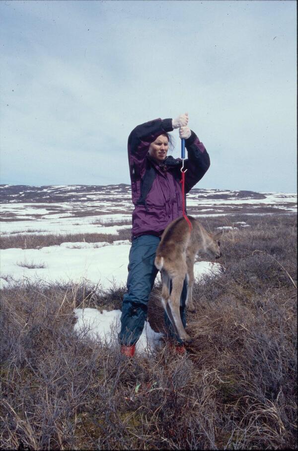
USGS biologist weighs a newborn caribou calf in Alaska
USGS biologist Gretchen Roffler weighs a newborn caribou calf in Denali National Park, Alaska.
USGS biologist Gretchen Roffler weighs a newborn caribou calf in Denali National Park, Alaska.

USGS hydrologic technician collecting groundwater level data
USGS hydrologic technician Jayson Blom collects a groundwater-level measurement from an aquifer monitoring well at the Idaho National Laboratory.
USGS hydrologic technician Jayson Blom collects a groundwater-level measurement from an aquifer monitoring well at the Idaho National Laboratory.

USGS Science Aids Manatees
For nearly four decades, the U.S. Geological Survey's Sirenia Project has been committed to understanding the biology and ecology of the West Indian manatee to aid managers in actions that could best help the population. To do this, USGS manatee researchers rely on a variety of tools and techniques.
For nearly four decades, the U.S. Geological Survey's Sirenia Project has been committed to understanding the biology and ecology of the West Indian manatee to aid managers in actions that could best help the population. To do this, USGS manatee researchers rely on a variety of tools and techniques.

USGS scientist and GeoGirls viewing Mount St. Helens
USGS scientists Kate Allstadt and Cynthia Gardner tell the story of the May 18, 1980 eruption of Mount St. Helens and how the catastrophic landslide, lateral blast, and lahar changed the landscape.
USGS scientists Kate Allstadt and Cynthia Gardner tell the story of the May 18, 1980 eruption of Mount St. Helens and how the catastrophic landslide, lateral blast, and lahar changed the landscape.

USGS scientist collecting sample from the stream prior to manure spill
USGS scientist collecting a water sample from the stream prior to the swine manure spill.
USGS scientist collecting a water sample from the stream prior to the swine manure spill.

USGS scientist collects precise elevation data in the breach
USGS scientist Owen Brenner walks across the Fire Island wilderness breach carrying a GPS backpack that allows him to collect precise elevation data in the shallows.
USGS scientist Owen Brenner walks across the Fire Island wilderness breach carrying a GPS backpack that allows him to collect precise elevation data in the shallows.

USGS scientist collects samples in a New Jersey salt marsh
Caption: USGS scientist Zafer Defne measures water and sediment movement at Forsythe National Wildlife Refuge, New Jersey. Defne is co-author with USGS' Neil Ganju of a 2017 study on how to estimate coastal salt marshes' potential longevity, based on their sediment budgets and the ratio of open water to vegetation. Photo: Sandra Brosnahan, USGS
Caption: USGS scientist Zafer Defne measures water and sediment movement at Forsythe National Wildlife Refuge, New Jersey. Defne is co-author with USGS' Neil Ganju of a 2017 study on how to estimate coastal salt marshes' potential longevity, based on their sediment budgets and the ratio of open water to vegetation. Photo: Sandra Brosnahan, USGS

USGS Scientist Examining Texas Rock Layers for Finchite Minerals
USGS scientist Bradley Van Gosen examines rock layers for the newly discovered mineral finchite near Lamesa, Texas.
USGS scientist Bradley Van Gosen examines rock layers for the newly discovered mineral finchite near Lamesa, Texas.

USGS scientist places radiocollar on a sedated bull caribou in Alaska
USGS scientist Layne Adams places a radiocollar on a sedated large bull caribou in Denali National Park, Alaska.
USGS scientist Layne Adams places a radiocollar on a sedated large bull caribou in Denali National Park, Alaska.