
Between Lamesa and Big Spring, Texas, runs the Sulfur Spring Draw, a dry creek. It's the site of an economic calcrete-type uranium deposit, the Sulfur Springs Draw Deposit, where a new mineral was discovered in 2015.
Images
Explore our planet through photography and imagery, including climate change and water all the way back to the 1800s when the USGS was surveying the country by horse and buggy.
Filter Total Items: 21545

USGS Scientists Seeking Finchite by the Sulfur Springs Draw in Texas
Between Lamesa and Big Spring, Texas, runs the Sulfur Spring Draw, a dry creek. It's the site of an economic calcrete-type uranium deposit, the Sulfur Springs Draw Deposit, where a new mineral was discovered in 2015.

USGS staff dig snowpits to evaluate the snow structure.
USGS staff dig snowpits to evaluate the snow structure after a wet snow avalanche cycle. This helps identify weak layers responsible for wet slab avalanches along the Going-to-the-Sun Road in Glacier National Park.
USGS staff dig snowpits to evaluate the snow structure after a wet snow avalanche cycle. This helps identify weak layers responsible for wet slab avalanches along the Going-to-the-Sun Road in Glacier National Park.

USGS truck
A USGS truck is parked on a small bridge crossing a stream. Small bits of snow lays in the grass next to the bridge.
A USGS truck is parked on a small bridge crossing a stream. Small bits of snow lays in the grass next to the bridge.

USGS vessel used to collect single-beam bathymetry
This USGS vessel acquires single-beam bathymetry in shallow nearshore environments. We acquire repeat bathymetry surveys over multiple years and compute changes in bathymetry, thus allowing us to identify hotspots of erosion and deposition on short timescales.
This USGS vessel acquires single-beam bathymetry in shallow nearshore environments. We acquire repeat bathymetry surveys over multiple years and compute changes in bathymetry, thus allowing us to identify hotspots of erosion and deposition on short timescales.

USGS Volunteer Student at the Smithsonian Natural History Museum
The Smithsonian Natural History Museum offers hands-on learning experiences.
The Smithsonian Natural History Museum offers hands-on learning experiences.

Vegetated dunes, beach, and water at Fire Island, New York
Photo showing multiple geomorphic environments including from left to right: the Atlantic Ocean, beach, dunes, and island interior.
Photo showing multiple geomorphic environments including from left to right: the Atlantic Ocean, beach, dunes, and island interior.

Wading in the breach to precisely measure it
USGS employee Owen Brenner walks across the Fire Island wilderness breach carrying a GPS backpack that allows him to collect precise elevation data in the shallows.
USGS employee Owen Brenner walks across the Fire Island wilderness breach carrying a GPS backpack that allows him to collect precise elevation data in the shallows.

Well House About 60 Kilometers East of Ulaanbaatar, Mongolia
Well house (white building in center of photograph) in the Upper Resource well field about 60 kilometers east of Ulaanbaatar, Mongolia. The Upper Resource supplies the best quality water to Ulaanbaatar because it is upstream from any major development.
Well house (white building in center of photograph) in the Upper Resource well field about 60 kilometers east of Ulaanbaatar, Mongolia. The Upper Resource supplies the best quality water to Ulaanbaatar because it is upstream from any major development.

WERC Technician with Invertebrate Fallout Trap, Nisqually River Delta
Lennah Shakeri, a USGS biological science technician, collects the contents of an invertebrate fallout trap at the Nisqually River Delta, WA.
Lennah Shakeri, a USGS biological science technician, collects the contents of an invertebrate fallout trap at the Nisqually River Delta, WA.

Whitefish drying on a fish rack in Pilot Station, AK
Whitefish drying on a fish rack in Pilot Station, AK, in the Yukon River Basin.
Whitefish drying on a fish rack in Pilot Station, AK, in the Yukon River Basin.
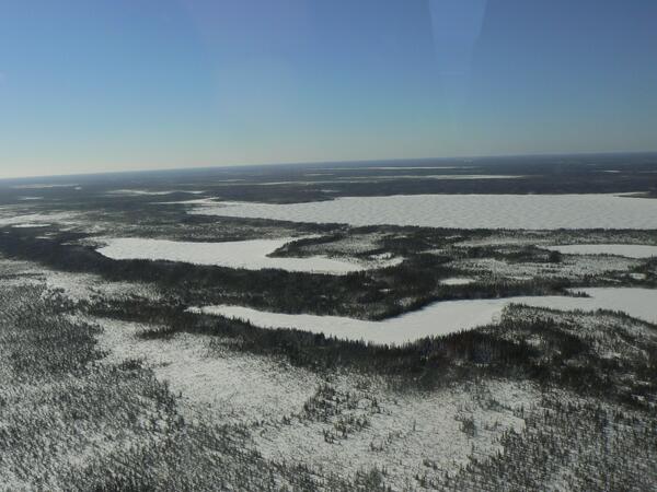
Winter landscape in northern Ontario, Canada
Winter landscape in northern Ontario, Canada.
Winter landscape in northern Ontario, Canada.

Woods Hole Coastal and Marine Science Center
Woods Hole Coastal and Marine Science Center side entrance to the Tilley Conference Room
Woods Hole Coastal and Marine Science Center side entrance to the Tilley Conference Room

Yellowstone subsurface cross-section schematic oriented SW-NE, depi...
Yellowstone subsurface cross-section schematic oriented SW-NE, depicts rise of magma beneath mantle plus heating and movement of mantle and crustal material. Credit Univ Utah. Click to enlarge.
Yellowstone subsurface cross-section schematic oriented SW-NE, depicts rise of magma beneath mantle plus heating and movement of mantle and crustal material. Credit Univ Utah. Click to enlarge.

A clear day at Kīlauea's summit
This view shows the north rim of Kīlauea Caldera, with the Hawaiian Volcano Observatory and Hawai‘i Volcanoes National Park's Jaggar Museum perched at the rim for ideal views of summit activity. Mauna Kea is in the distance, partially obscured by clouds, and Mauna Loa's Northeast Rift Zone extends off the left edge of the photo.
This view shows the north rim of Kīlauea Caldera, with the Hawaiian Volcano Observatory and Hawai‘i Volcanoes National Park's Jaggar Museum perched at the rim for ideal views of summit activity. Mauna Kea is in the distance, partially obscured by clouds, and Mauna Loa's Northeast Rift Zone extends off the left edge of the photo.

Bathymetry data of Columbia River mouth
Bathymetry data of Columbia River mouth, derived from an interferometric swath bathymetry systems survey in 2013. A) Swath map of data; B-E) sample detail pull-outs
Bathymetry data of Columbia River mouth, derived from an interferometric swath bathymetry systems survey in 2013. A) Swath map of data; B-E) sample detail pull-outs

HVO geologist wore protective gear during collection of fresh lava
On December 30, 2015, an HVO geologist wore protective gear during collection of a fresh lava sample for chemical analysis from a pāhoehoe breakout along scattered Pu‘u ‘Ō‘ō lava flows. Inset image caption: Metadata is written on a bag that holds a sample taken from pāhoehoe that was collected on August 18, 2006.
On December 30, 2015, an HVO geologist wore protective gear during collection of a fresh lava sample for chemical analysis from a pāhoehoe breakout along scattered Pu‘u ‘Ō‘ō lava flows. Inset image caption: Metadata is written on a bag that holds a sample taken from pāhoehoe that was collected on August 18, 2006.

Lithium Mining in Salar de Atacama, Chile
The Salar de Atacama in Chile is a large, dry salt flat surrounded by mountain ranges and is one of the driest places on Earth. Parts of the Atacama Desert have gone without rain for as long as people have been keeping track, but water rich in dissolved salts lies beneath this flat surface. The Salar is particularly rich in lithium salts.
The Salar de Atacama in Chile is a large, dry salt flat surrounded by mountain ranges and is one of the driest places on Earth. Parts of the Atacama Desert have gone without rain for as long as people have been keeping track, but water rich in dissolved salts lies beneath this flat surface. The Salar is particularly rich in lithium salts.

USGS Measures Historic Flooding Across the Nation
NBC Nightly News not only came out to interview USGS field crews on the Mississippi, they brought a team to fly overhead and capture video with a drone.
NBC Nightly News not only came out to interview USGS field crews on the Mississippi, they brought a team to fly overhead and capture video with a drone.

USGS Measures Historic Flooding Across the Nation
Local CBS 4 affiliate KMOV interviews USGS scientist Paul Rydlund from the Mississippi River in St. Louis.
Local CBS 4 affiliate KMOV interviews USGS scientist Paul Rydlund from the Mississippi River in St. Louis.

USGS Measures Historic Flooding Across the Nation
USGS crews had two research vessels out measuring streamflow on the Mississippi River at St. Louis on New Years Eve. USGS scientists Eric Looper and Jason Carron are one of many USGS field crews out in the floodwaters over the holiday.
USGS crews had two research vessels out measuring streamflow on the Mississippi River at St. Louis on New Years Eve. USGS scientists Eric Looper and Jason Carron are one of many USGS field crews out in the floodwaters over the holiday.