
Prescribed fires, such as this one, are used by land managers to restore ponderosa pine forests to more resilient conditions. We are fortunate to be able to occasionally participate in such burns because we are co-located with land managers.
Images
Explore our planet through photography and imagery, including climate change and water all the way back to the 1800s when the USGS was surveying the country by horse and buggy.
Filter Total Items: 21545

A fire burns along the ground in a ponderosa pine forest, New Mexico
Prescribed fires, such as this one, are used by land managers to restore ponderosa pine forests to more resilient conditions. We are fortunate to be able to occasionally participate in such burns because we are co-located with land managers.
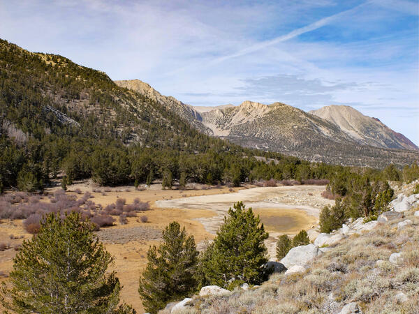
Kenneth Lake, California
Spruce-covered mountains surround a dried-up lake.
Spruce-covered mountains surround a dried-up lake.

Data collection sonde in the swash zone at Lake Tahoe
Data collection sonde in the swash zone at Lake Tahoe. Data was being collected for the Lake Tahoe Nearshore Periphyton study.
Data collection sonde in the swash zone at Lake Tahoe. Data was being collected for the Lake Tahoe Nearshore Periphyton study.

Planetary Caves' Role in Astronaut Bases and the Search for Life
Attendees of the 2nd International Planetary Caves Conference pose for a photo. Participants include a local high-school robotics team, called the CocoNuts.
Attendees of the 2nd International Planetary Caves Conference pose for a photo. Participants include a local high-school robotics team, called the CocoNuts.

Planetary Caves' Role in Astronaut Bases and the Search for Life
During the 2nd International Planetary Caves Conference, attendees explored Lava River cave, located near Flagstaff, Arizona. This photo was taken using time-lapse photography and the light streak is the result of person walking with a headlamp.
During the 2nd International Planetary Caves Conference, attendees explored Lava River cave, located near Flagstaff, Arizona. This photo was taken using time-lapse photography and the light streak is the result of person walking with a headlamp.

Planetary Caves' Role in Astronaut Bases and the Search for Life
During the 2nd International Planetary Caves Conference, attendees explored a 1.6-kilometer-long lava tube cave, northwest of Flagstaff, Arizona.
During the 2nd International Planetary Caves Conference, attendees explored a 1.6-kilometer-long lava tube cave, northwest of Flagstaff, Arizona.

Benthic Flux Chamber
The oxygen-regulated benthic flux chamber measures fluxes of water and chemical species across the sediment water interface. It is shown here deployed in the subtidal discharge zone in Indian River Bay, DE, USA
The oxygen-regulated benthic flux chamber measures fluxes of water and chemical species across the sediment water interface. It is shown here deployed in the subtidal discharge zone in Indian River Bay, DE, USA

Measuring streamflow of New Fork River
Measuring streamflow of New Fork River
Measuring streamflow of New Fork River

School Branch at Brownsburg IN - crawfish
School Branch at Brownsburg IN - crawfish
School Branch at Brownsburg IN - crawfish

School Branch at Brownsburg, IN - crawfish
School Branch at Brownsburg, IN - crawfish
School Branch at Brownsburg, IN - crawfish

Lake Michigan Ecological Research Station
The Lake Michigan Ecological Research Center. Please see our Locations page for more information
The Lake Michigan Ecological Research Center. Please see our Locations page for more information

Earth Resources Observation and Science Center
The exterior of the Earth Resources Observation and Science Center near Sioux Falls, SD, USA.
The exterior of the Earth Resources Observation and Science Center near Sioux Falls, SD, USA.

External image of EROS Center
External view of the EROS Center on a fall day. Watch and hear a video regarding the Center at this URL https://www.youtube.com/watch?v=lE_vsuGxso8
External view of the EROS Center on a fall day. Watch and hear a video regarding the Center at this URL https://www.youtube.com/watch?v=lE_vsuGxso8

Ohio River at Ironton, OH - bridge side view
Ohio River at Ironton, OH - bridge side view
Ohio River at Ironton, OH - bridge side view

Ohio River at Ironton, OH - equipment
Ohio River at Ironton, OH - equipment
Ohio River at Ironton, OH - equipment

Ohio River at Ironton, OH - gage in tower
Ohio River at Ironton, OH - gage in tower
Ohio River at Ironton, OH - gage in tower

Debris flow in channel near Butte Camp, Mount St. Helens, WA.
Debris flow in channel near Butte Camp, Mount St. Helens, Washington.
Debris flow in channel near Butte Camp, Mount St. Helens, Washington.

R. Behrens on bridge protection pier, Rockaway Inlet station, NY
Northeast Region Photo Contest Winner | November 2018 | Where We Work
R. Behrens on bridge protection pier, Rockaway Inlet station, NY
Northeast Region Photo Contest Winner | November 2018 | Where We Work
R. Behrens on bridge protection pier, Rockaway Inlet station, NY

A U.S. Geological Survey hydrologist collects a water sample
After receiving permission from the homeowner, a U.S. Geological Survey hydrologist collects a water sample from a residential well in Emmett, Idaho. The sample was analyzed as part of a water-quality study the USGS conducted in cooperation with Gem County, Idaho and the Idaho Department of Environmental Quality.
After receiving permission from the homeowner, a U.S. Geological Survey hydrologist collects a water sample from a residential well in Emmett, Idaho. The sample was analyzed as part of a water-quality study the USGS conducted in cooperation with Gem County, Idaho and the Idaho Department of Environmental Quality.

Two corals during an ocean heatwave on the Florida reef tract
Here are shown two mustard hill corals (Porites astreoides) growing side-by-side, one (right) that has succumbed to heat stress and lost its symbiotic algae, and one (left) that has not.
Here are shown two mustard hill corals (Porites astreoides) growing side-by-side, one (right) that has succumbed to heat stress and lost its symbiotic algae, and one (left) that has not.

Bleached mountainous star coral at Hen and Chickens Sanctuary
A diver peeks from behind a badly bleached coral in the Florida Keys National Marine Sanctuary in October 2015. Coral bleaching events caused by abnormally warm ocean temperatures continue to regularly claim the lives of coral populations around the globe.
A diver peeks from behind a badly bleached coral in the Florida Keys National Marine Sanctuary in October 2015. Coral bleaching events caused by abnormally warm ocean temperatures continue to regularly claim the lives of coral populations around the globe.