
A University of Hawai‘i at Mānoa graduate student uses a compass to check the orientation of a seismic node (blue) that was deployed on Kīlauea's Southwest Rift Zone over the past two months. Seismic nodes are small and light seismometers that measure ground shaking at the location where they are placed.
Images
Volcano Hazard Program images.
Filter Total Items: 6230

September 6, 2022 — Kīlauea Southwest Rift Zone Seismic Nodes Being Collected
A University of Hawai‘i at Mānoa graduate student uses a compass to check the orientation of a seismic node (blue) that was deployed on Kīlauea's Southwest Rift Zone over the past two months. Seismic nodes are small and light seismometers that measure ground shaking at the location where they are placed.

September 6, 2022 — Kīlauea Southwest Rift Zone Seismic Nodes Being Collected
Scientists take notes about the seismic station being collected from the field, where it has been collecting data for the past two months. These temporary seismic node stations were tightly grouped over Kīlauea's Southwest Rift Zone and Pāhala area in order to more densely record earthquake signals across the region.
Scientists take notes about the seismic station being collected from the field, where it has been collecting data for the past two months. These temporary seismic node stations were tightly grouped over Kīlauea's Southwest Rift Zone and Pāhala area in order to more densely record earthquake signals across the region.

September 6, 2022 — Kīlauea Southwest Rift Zone Lava Tree
Lava erupted from Kīlauea's Southwest Rift Zone in 1823 formed this lava tree that stands approximately 4 feet (1.2 meters) high. Lava trees form when hot and flowing lava contacts a cool and moist tree, forming a coating of solid lava.
Lava erupted from Kīlauea's Southwest Rift Zone in 1823 formed this lava tree that stands approximately 4 feet (1.2 meters) high. Lava trees form when hot and flowing lava contacts a cool and moist tree, forming a coating of solid lava.

September 6, 2022 — Kīlauea Southwest Rift Zone Lava Tree
During the 1823 eruption of Kīlauea's Southwest Rift Zone, lava contacted a tree. It quickly cooled, insulating the tree for a short time from the lava that continued to flow around it.
During the 1823 eruption of Kīlauea's Southwest Rift Zone, lava contacted a tree. It quickly cooled, insulating the tree for a short time from the lava that continued to flow around it.

September 6, 2022 — Kīlauea Southwest Rift Zone Seismic Nodes Being Collected
Hawaiian Volcano Observatory staff and University of Hawai‘i at Mānoa collaborators walk on lava flows from 1823 along the Hawai‘i Volcanoes National Park boundary fence as they hike to collect seismic nodes that have been deployed in Kīlauea's Southwest Rift Zone for the past two months.
Hawaiian Volcano Observatory staff and University of Hawai‘i at Mānoa collaborators walk on lava flows from 1823 along the Hawai‘i Volcanoes National Park boundary fence as they hike to collect seismic nodes that have been deployed in Kīlauea's Southwest Rift Zone for the past two months.

September 2, 2022 — Kīlauea summit eruption monitoring
An HVO geologist uses a telephoto camera lens to document Kīlauea's summit eruption from the south rim of Halema‘uma‘u on September 2, 2022. The slope of Mauna Loa's Northeast Rift Zone is visible in the background of the left side of the image, whereas the summit of Kīlauea, at Uēkahuna Bluff, is visible in the background of the right side of the image.
An HVO geologist uses a telephoto camera lens to document Kīlauea's summit eruption from the south rim of Halema‘uma‘u on September 2, 2022. The slope of Mauna Loa's Northeast Rift Zone is visible in the background of the left side of the image, whereas the summit of Kīlauea, at Uēkahuna Bluff, is visible in the background of the right side of the image.

September 2, 2022 — Kīlauea summit eruption monitoring
A telephoto view of the active lava lake within Halema‘uma‘u crater, at the summit of Kīlauea volcano. The active lava lake is approximately 3 acres (1 hectare) in area; however, lava flows from this eruption, which began on September 29, 2021, have covered approximately 282 acres (114 hectares). USGS image by K. Mulliken.
A telephoto view of the active lava lake within Halema‘uma‘u crater, at the summit of Kīlauea volcano. The active lava lake is approximately 3 acres (1 hectare) in area; however, lava flows from this eruption, which began on September 29, 2021, have covered approximately 282 acres (114 hectares). USGS image by K. Mulliken.

September 2, 2022 — Kīlauea summit eruption monitoring
South of the active lava lake within Halema‘uma‘u, there is a much smaller lava pond. Lava flows that appear darker grey and shiny around this feature attest to recent overflows. Telephoto image taken from the south rim of Halema‘uma‘u on September 2, 2022. USGS image by K. Mulliken.
South of the active lava lake within Halema‘uma‘u, there is a much smaller lava pond. Lava flows that appear darker grey and shiny around this feature attest to recent overflows. Telephoto image taken from the south rim of Halema‘uma‘u on September 2, 2022. USGS image by K. Mulliken.

September 2, 2022 — Kīlauea summit eruption monitoring
A telephoto view of the eastern end of Halema‘uma‘u crater floor, where lava flows erupted over the past year intersect the crater wall. The fissure that erupted in 1982 on Kīlauea caldera floor is visible as a ridge-like feature about 130 feet (40 meters) above these lava flows. USGS image by K. Mulliken.
A telephoto view of the eastern end of Halema‘uma‘u crater floor, where lava flows erupted over the past year intersect the crater wall. The fissure that erupted in 1982 on Kīlauea caldera floor is visible as a ridge-like feature about 130 feet (40 meters) above these lava flows. USGS image by K. Mulliken.

September 2, 2022 — Kīlauea summit eruption monitoring
A view of the eruption in Halema‘uma‘u at the summit of Kīlauea, taken on September 2, 2022, by HVO geologists on the south rim of the crater. Nice weather allowed for clear views of the active lava lake, which is in approximately the center of the image.
A view of the eruption in Halema‘uma‘u at the summit of Kīlauea, taken on September 2, 2022, by HVO geologists on the south rim of the crater. Nice weather allowed for clear views of the active lava lake, which is in approximately the center of the image.
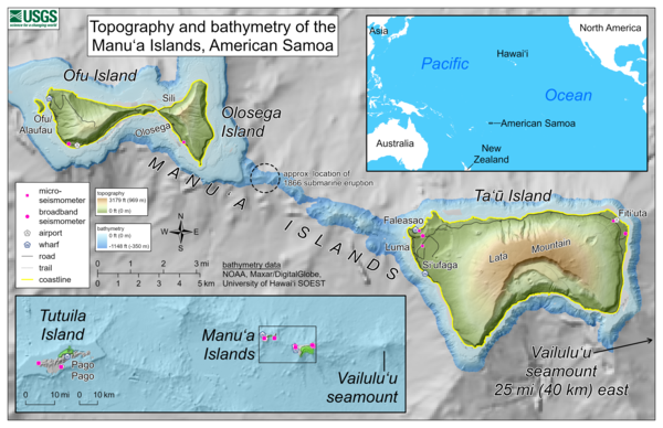
Topography and bathymetry of the Manu‘a Islands, American Samoa
This reference map depicts the topography and bathymetry of the volcanoes in the Manu‘a Islands, American Samoa, where seismic unrest has been ongoing for several weeks. The highest elevation in the area is Lata Mountain on Ta‘ū Island, standing 3,179 feet (969 meters) above sea level.
This reference map depicts the topography and bathymetry of the volcanoes in the Manu‘a Islands, American Samoa, where seismic unrest has been ongoing for several weeks. The highest elevation in the area is Lata Mountain on Ta‘ū Island, standing 3,179 feet (969 meters) above sea level.

Map showing location of Ta'ū volcano in American Samoa and Wake Island
Wake Island is about 2,800 miles (4,500 km) northwest of Ta'ū volcano in American Samoa. Both are located in the Pacific Ocean.
Wake Island is about 2,800 miles (4,500 km) northwest of Ta'ū volcano in American Samoa. Both are located in the Pacific Ocean.

Topography, bathymetry, and volcano monitoring network of the Manu‘a Islands, American Samoa
This reference map depicts the topography and bathymetry of the volcanoes in the Manu‘a Islands, American Samoa. The highest elevation in the area is Lata Mountain on Ta‘ū Island, standing 3,179 feet (969 meters) above sea level.
This reference map depicts the topography and bathymetry of the volcanoes in the Manu‘a Islands, American Samoa. The highest elevation in the area is Lata Mountain on Ta‘ū Island, standing 3,179 feet (969 meters) above sea level.

Oblique view of an example simulation showing lava flow advance
Oblique view of an example simulation showing lava flow advance from Fissure 22 (white line segments) of the 2018 Kīlauea lower East Rift Zone eruption. Color contours show the lava flow front in 1-hour increments. The simulated flow entered the ocean after 22 hours elapsed, comparable to the actual timeframe it took that lava flow to reach the ocean.
Oblique view of an example simulation showing lava flow advance from Fissure 22 (white line segments) of the 2018 Kīlauea lower East Rift Zone eruption. Color contours show the lava flow front in 1-hour increments. The simulated flow entered the ocean after 22 hours elapsed, comparable to the actual timeframe it took that lava flow to reach the ocean.

Kīlauea Volcano crater filling as of September 2022
This map of the Kīlauea summit is mostly identical to the September 13, 2022, eruption reference map, but also included here are west to east topographic profiles across the caldera.
This map of the Kīlauea summit is mostly identical to the September 13, 2022, eruption reference map, but also included here are west to east topographic profiles across the caldera.

August 30, 2022 — Collecting Rock Samples on Ta‘ū Island
A USGS Hawaiian Volcano Observatory geologist collects a rock sample using a rock hammer on Ta‘ū Island, American Samoa. HVO staff are in American Samoa responding to earthquake activity. While there to install monitoring instrumentation, they are also collecting rock samples to better understand past volcanic activity in American Samoa. USGS image by J. Chang.
A USGS Hawaiian Volcano Observatory geologist collects a rock sample using a rock hammer on Ta‘ū Island, American Samoa. HVO staff are in American Samoa responding to earthquake activity. While there to install monitoring instrumentation, they are also collecting rock samples to better understand past volcanic activity in American Samoa. USGS image by J. Chang.

August 30, 2022 — Collecting Rock Samples on Ta‘ū Island
A USGS Hawaiian Volcano Observatory geologist collects a sample of a pāhoehoe lava flow above a thick ‘a‘ā lava flow on Ta‘ū Island, American Samoa. At that location, samples of a sequence of alternating pāhoehoe and ‘a‘ā lava flows were sampled to help reconstruct the eruptive history of Ta‘ū volcano.
A USGS Hawaiian Volcano Observatory geologist collects a sample of a pāhoehoe lava flow above a thick ‘a‘ā lava flow on Ta‘ū Island, American Samoa. At that location, samples of a sequence of alternating pāhoehoe and ‘a‘ā lava flows were sampled to help reconstruct the eruptive history of Ta‘ū volcano.

August 26, 2022 — Tuff cone on Ta‘ū Island in American Samoa
A cliff on Ta‘ū island in American Samoa, exposing part of a tuff cone that was created from phreatomagmatic processes through the interaction of lava with shallow seawater. This part of the tuff cone contains mostly sand-sized material that hosts larger blocks and bombs that are up to several feet (one meter) in diameter.
A cliff on Ta‘ū island in American Samoa, exposing part of a tuff cone that was created from phreatomagmatic processes through the interaction of lava with shallow seawater. This part of the tuff cone contains mostly sand-sized material that hosts larger blocks and bombs that are up to several feet (one meter) in diameter.

August 26, 2022 — Base of a tuff cone on Ta‘ū Island, American Samoa
The base of a tuff cone near the coast of Ta‘ū Island in American Samoa. Tuff cones are created from phreatomagmatic processes through the interaction of lava with shallow seawater. This part of the tuff cone contains mostly sand size material that hosts larger blocks and bombs that are up to several feet (one meter) in diameter.
The base of a tuff cone near the coast of Ta‘ū Island in American Samoa. Tuff cones are created from phreatomagmatic processes through the interaction of lava with shallow seawater. This part of the tuff cone contains mostly sand size material that hosts larger blocks and bombs that are up to several feet (one meter) in diameter.

GNSS receivers, antennas, and associated cables
Staging of new state-of-the-art GNSS receivers, antennas, and associated cables acquired through the Additional Supplemental Appropriations for Disaster Relief Act of 2019 for the USGS Hawaiian Volcano Observatory. USGS photo by A.P Ellis.
Staging of new state-of-the-art GNSS receivers, antennas, and associated cables acquired through the Additional Supplemental Appropriations for Disaster Relief Act of 2019 for the USGS Hawaiian Volcano Observatory. USGS photo by A.P Ellis.

HVO permanent, continuously operating GNSS site
HVO permanent, continuously operating GNSS site in Hawai‘i Volcanoes National Park co-located with seismic instrumentation. USGS photo by K. Kamibayashi.
HVO permanent, continuously operating GNSS site in Hawai‘i Volcanoes National Park co-located with seismic instrumentation. USGS photo by K. Kamibayashi.