
A telephoto image of the the west vent taken on the morning of October 15, during an HVO helicopter overflight of Kīlauea summit. Low lava fountaining activity continues from the vent in the western wall of Halema‘uma‘u.
Images
Volcano Hazard Program images.
Filter Total Items: 6230

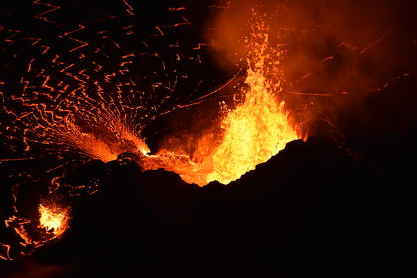
Active west vent in Halema‘uma‘u—October 15, 2021
A telephoto image of the the west vent taken on the morning of October 15, during an HVO helicopter overflight of Kīlauea summit. Low lava fountaining activity continues from the vent in the western wall of Halema‘uma‘u.

Scientist collects data—Kīlauea eruption overflight—Oct. 15, 2021
Hawaiian Volcano Observatory scientists make observations and collect data during Kīlauea eruption overflights. The data collected is used to construct updated topographic and thermal maps of the lava lake surface and surrounding area.
Hawaiian Volcano Observatory scientists make observations and collect data during Kīlauea eruption overflights. The data collected is used to construct updated topographic and thermal maps of the lava lake surface and surrounding area.

Different views of an eruption from two predictable geysers
Different views of an eruption from two predictable geysers. (a, c) Graphs showing water temperatures recorded by data loggers stationed near Beehive and Old Faithful Geysers, respectively. These data loggers were deployed by the Yellowstone Geology Program, configured to capture temperatures at one-minute intervals (indicated by blue dots).
Different views of an eruption from two predictable geysers. (a, c) Graphs showing water temperatures recorded by data loggers stationed near Beehive and Old Faithful Geysers, respectively. These data loggers were deployed by the Yellowstone Geology Program, configured to capture temperatures at one-minute intervals (indicated by blue dots).

Example initial analyses on the water temperature data
Example initial analyses on the water temperature data. (a, c) Graphs showing the calculated time between eruptions. (b, d) Histograms demonstrating the distribution of eruption intervals.
Example initial analyses on the water temperature data. (a, c) Graphs showing the calculated time between eruptions. (b, d) Histograms demonstrating the distribution of eruption intervals.

Yellowstone Lake map showing the location of the Deep Hole vent field
Yellowstone Lake bathymetry showing the location of the Deep Hole vent field. Inset shows locations of heat-flux measurements (red dots) in the Deep Hole vent field.
Yellowstone Lake bathymetry showing the location of the Deep Hole vent field. Inset shows locations of heat-flux measurements (red dots) in the Deep Hole vent field.

Research Vessel Annie and Remotely Operated Vehicle Yogi
Research Vessel Annie and Remotely Operated Vehicle Yogi. a) R/V Annie on Yellowstone Lake operated by the Global Foundation for Ocean Exploration. Image Rob Harris, OSU. b) ROV Yogi with GFOE President Dave Lovalvo. Image Todd Gregory, GFOE. C) ROV Yogi and 1-m heat flow probe. This pr
Research Vessel Annie and Remotely Operated Vehicle Yogi. a) R/V Annie on Yellowstone Lake operated by the Global Foundation for Ocean Exploration. Image Rob Harris, OSU. b) ROV Yogi with GFOE President Dave Lovalvo. Image Todd Gregory, GFOE. C) ROV Yogi and 1-m heat flow probe. This pr

Lava fountaining at the west vent—October 14, 2021
A close-up photo of the vent in the western wall of Halema‘uma‘u, taken during the ongoing eruption at Kīlauea summit. The top of the 5–6 m (16–20 ft) tall lava fountain could be seen from the west crater rim on October 14, at 2:05 p.m. The lava fountains continue to build up a spatter cone around the vent.
A close-up photo of the vent in the western wall of Halema‘uma‘u, taken during the ongoing eruption at Kīlauea summit. The top of the 5–6 m (16–20 ft) tall lava fountain could be seen from the west crater rim on October 14, at 2:05 p.m. The lava fountains continue to build up a spatter cone around the vent.

October 13, 2021 — Kīlauea summit eruption
A view of the western portion of the lava lake within Halema‘uma‘u, at the summit of Kīlauea. This photo, taken from the west crater rim, shows the active west vent (lower right), the main island (upper left), and the old west vent from the Dec. 2020–May 2021 eruption (lower left).
A view of the western portion of the lava lake within Halema‘uma‘u, at the summit of Kīlauea. This photo, taken from the west crater rim, shows the active west vent (lower right), the main island (upper left), and the old west vent from the Dec. 2020–May 2021 eruption (lower left).

Kīlauea summit eruption - October 12, 2021
A wide view of the ongoing eruption at Kīlauea summit, from the south rim of Halema‘uma‘u. A vent on the western crater wall (left) continues to supply lava to the active west half of the lava lake.
A wide view of the ongoing eruption at Kīlauea summit, from the south rim of Halema‘uma‘u. A vent on the western crater wall (left) continues to supply lava to the active west half of the lava lake.

Kīlauea summit eruption - October 12, 2021
Associated with an increase in fountaining activity at the main western vent in Halema‘uma‘u, a short-lived vent opened just to the north (right). Activity at this vent lasted about 10 hours with low-level fountaining about 3 meters (10 ft) high.
Associated with an increase in fountaining activity at the main western vent in Halema‘uma‘u, a short-lived vent opened just to the north (right). Activity at this vent lasted about 10 hours with low-level fountaining about 3 meters (10 ft) high.

Kīlauea summit eruption - October 12, 2021
A view of the fountaining at the west vent in Halema‘uma‘u crater, at the summit of Kīlauea. The photo was taken from the west rim, looking down upon the vent. Low fountaining and roiling within the cone supplied lava to the lake via a narrow spillway. Lava spreading out into the lake develops a zig-zag pattern in the surface crust. USGS photo by M.
A view of the fountaining at the west vent in Halema‘uma‘u crater, at the summit of Kīlauea. The photo was taken from the west rim, looking down upon the vent. Low fountaining and roiling within the cone supplied lava to the lake via a narrow spillway. Lava spreading out into the lake develops a zig-zag pattern in the surface crust. USGS photo by M.
Kīlauea summit eruption - October 12, 2021
Lava fountains from the western vent within Halema‘uma‘u continue to supply lava into the lava lake through a short spillway. Consistent fountain heights of 10–15 meters (30–50 ft) were interrupted by frequent larger busts of spatter exceeding the height of the cone (30 m or 100 ft). USGS photo taken by B. Carr on October 12, 2021.
Lava fountains from the western vent within Halema‘uma‘u continue to supply lava into the lava lake through a short spillway. Consistent fountain heights of 10–15 meters (30–50 ft) were interrupted by frequent larger busts of spatter exceeding the height of the cone (30 m or 100 ft). USGS photo taken by B. Carr on October 12, 2021.

October 11, 2021 — Kīlauea
This zoomed-in view of the western fissure within Halema‘uma‘u, at the summit of Kīlauea, was captured on October 11, 2021, through the lens of a laser rangefinder. A prominent horseshoe-shaped spatter cone, measured to be standing 28 m (92 ft) above the adjacent lava lake, surrounds a roiling lava pond which also hosts taller fountains at times.
This zoomed-in view of the western fissure within Halema‘uma‘u, at the summit of Kīlauea, was captured on October 11, 2021, through the lens of a laser rangefinder. A prominent horseshoe-shaped spatter cone, measured to be standing 28 m (92 ft) above the adjacent lava lake, surrounds a roiling lava pond which also hosts taller fountains at times.

October 11, 2021 — Kīlauea
This zoomed-in view of the northwest side of the main island within the Halema‘uma‘u lava lake shows a "rootless lava flow" (silver) that formed in the early stages of the eruption on September 29, 2021.
This zoomed-in view of the northwest side of the main island within the Halema‘uma‘u lava lake shows a "rootless lava flow" (silver) that formed in the early stages of the eruption on September 29, 2021.

VMAP Vog Dashboard: public forecast for October 11, 2021
VMAP Vog Dashboard: public forecast for October 11, 2021. Colors denote probability of exceeding ‘Moderate’ sulfur dioxide air quality threshold. Source: http://weather.hawaii.edu/vmap/new/
VMAP Vog Dashboard: public forecast for October 11, 2021. Colors denote probability of exceeding ‘Moderate’ sulfur dioxide air quality threshold. Source: http://weather.hawaii.edu/vmap/new/

October 10, 2021 — Kīlauea, lava fountaining in Halema‘uma‘u
Fountaining at the western vent in Halema‘uma‘u crater, at Kīlauea volcano's summit, was approximately 15 meters (50 feet) high on the evening of October 10, 2021. Spatter from the fountaining would occasionally land on the wall of the vent cone and cool (visible on the right).
Fountaining at the western vent in Halema‘uma‘u crater, at Kīlauea volcano's summit, was approximately 15 meters (50 feet) high on the evening of October 10, 2021. Spatter from the fountaining would occasionally land on the wall of the vent cone and cool (visible on the right).

October 10, 2021 — Kīlauea, Halema‘uma‘u lava lake at dusk
Lava fountaining activity continues from the western vent in Halema‘uma‘u, within Kīlauea summit caldera, viewed at dusk on October 10, 2021, from the west rim of the crater. Only the western half of the lake surface is active; the eastern half is covered by a cooling, solidified crust. USGS image by B. Carr.
Lava fountaining activity continues from the western vent in Halema‘uma‘u, within Kīlauea summit caldera, viewed at dusk on October 10, 2021, from the west rim of the crater. Only the western half of the lake surface is active; the eastern half is covered by a cooling, solidified crust. USGS image by B. Carr.

Michael Poland
Photograph of Michael Poland, geophysicist with the U.S. Geological Survey and Scientist-in-Charge of the Yellowstone Volcano Observatory.
Photograph of Michael Poland, geophysicist with the U.S. Geological Survey and Scientist-in-Charge of the Yellowstone Volcano Observatory.

October 9, 2021 — Kīlauea, summit eruptive vent
HVO scientists captured this zoomed-in photo of the western fissure within Halema‘uma‘u through the lens of a laser rangefinder on October 9, 2021. The fissure has formed a horseshoe-shaped spatter cone around its source, with an opening on the east (right) side allowing lava to flow into the active lava lake.
HVO scientists captured this zoomed-in photo of the western fissure within Halema‘uma‘u through the lens of a laser rangefinder on October 9, 2021. The fissure has formed a horseshoe-shaped spatter cone around its source, with an opening on the east (right) side allowing lava to flow into the active lava lake.

October 8, 2021 — Kīlauea summit eruption
Though not every ānuenue (rainbow) has an actively erupting volcanic fissure at its end, this one did for a brief moment during HVO scientists' helicopter overflight of the Kīlauea summit on the morning of October 8, 2021.
Though not every ānuenue (rainbow) has an actively erupting volcanic fissure at its end, this one did for a brief moment during HVO scientists' helicopter overflight of the Kīlauea summit on the morning of October 8, 2021.

October 8, 2021 — Kīlauea summit eruption
On the morning of October 8, 2021, HVO scientists completed a routine helicopter overflight of the ongoing eruption within Halema‘uma‘u at the summit of Kīlauea.
On the morning of October 8, 2021, HVO scientists completed a routine helicopter overflight of the ongoing eruption within Halema‘uma‘u at the summit of Kīlauea.