

An interview with USGS scientist emeritus Richie Williams about his career studying the Earth's cryosphere with remote sensing technology.
Alex Demas (Former Employee)
(He/him)Science and Products
Filter Total Items: 845
An interview with USGS scientist emeritus Richie Williams about his career studying the Earth's cryosphere with remote sensing technology.
USGS Releases Latest Bakken Oil and Gas Assessment
On April 30, 2013, USGS released an updated assessment of the Bakken Formation of North Dakota and Montana as part of the National Oil and Gas Assessment.
On April 30, 2013, USGS released an updated assessment of the Bakken Formation of North Dakota and Montana as part of the National Oil and Gas Assessment.
USGS Releases Resource Estimate for Afghanistan Rare Earth Prospect
The U.S. Geological Survey estimates at least 1 million metric tonnes of rare earth element resources within the Khanneshin carbonatite in Helmand Province, Afghanistan. This estimate comes from a 2009-2011 USGS study funded by the Department of Defense's Task Force for Business and Stability Operations.
The U.S. Geological Survey estimates at least 1 million metric tonnes of rare earth element resources within the Khanneshin carbonatite in Helmand Province, Afghanistan. This estimate comes from a 2009-2011 USGS study funded by the Department of Defense's Task Force for Business and Stability Operations.
USGS Takes Streamflow Measurements
USGS crews aboard the Butta Bean measure streamflow on the Mississippi River during the 2011 Flood. At the height of the flood, USGS crews are out every other day taking streamflow measurements to ensure the US Army Corps of Engineers has accurate, up-to-date information with which to base its river management decisions.
USGS crews aboard the Butta Bean measure streamflow on the Mississippi River during the 2011 Flood. At the height of the flood, USGS crews are out every other day taking streamflow measurements to ensure the US Army Corps of Engineers has accurate, up-to-date information with which to base its river management decisions.
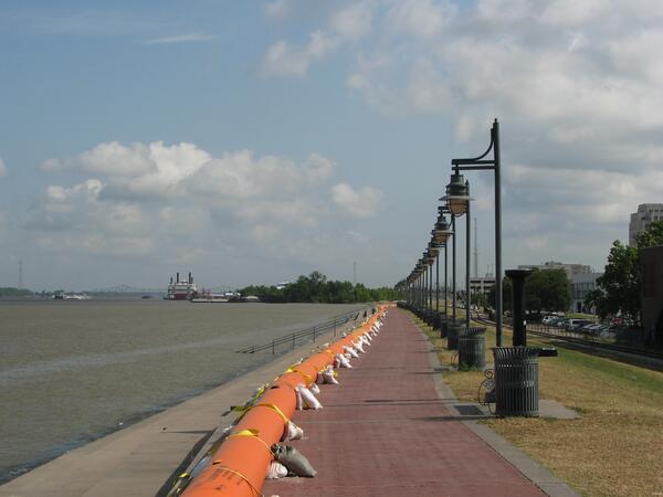
Tiger Dams Reinforce Baton Rouge Levees
Tiger Dams line the Baton Rouge Mississippi River levee during the 2011 Flood. Previously used to prevent oil from reaching Louisiana's coast during the 2010 Deepwater Horizon oil spill, these Tiger Dams are filled with water and reinforced with sandbags to give the Baton Rouge Mississippi River levee an extra foot of height. This additional height is pr
Tiger Dams line the Baton Rouge Mississippi River levee during the 2011 Flood. Previously used to prevent oil from reaching Louisiana's coast during the 2010 Deepwater Horizon oil spill, these Tiger Dams are filled with water and reinforced with sandbags to give the Baton Rouge Mississippi River levee an extra foot of height. This additional height is pr
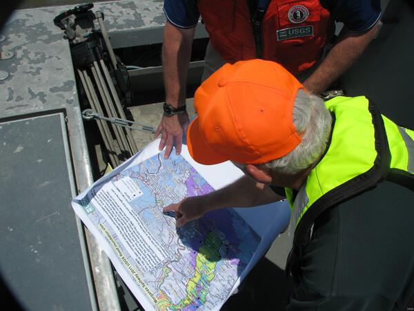
George Arcement Shows Locations of USGS Streamgages
USGS Louisiana Water Science Center Director George Arcement shows the locations of USGS' streamgage network to WAFB Meteorologist Jay Grymes. USGS maintains more than 30 real-time streamgages throughout the area affected by the 2011 Flood.
USGS Louisiana Water Science Center Director George Arcement shows the locations of USGS' streamgage network to WAFB Meteorologist Jay Grymes. USGS maintains more than 30 real-time streamgages throughout the area affected by the 2011 Flood.
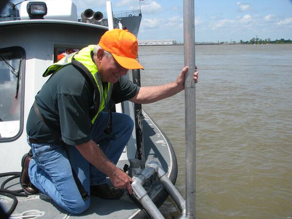
George Arcement Demonstrates the ADCP
USGS Water Science Center Director George Arcement demonstrates the Acoustic Doppler Current Profiler (ADCP) to legislative staffers. USGS uses the ADCP to make streamflow measurements. The ADCP emits soundwaves through the water column, which rebound off particles in the water until they reach the river bottom.
USGS Water Science Center Director George Arcement demonstrates the Acoustic Doppler Current Profiler (ADCP) to legislative staffers. USGS uses the ADCP to make streamflow measurements. The ADCP emits soundwaves through the water column, which rebound off particles in the water until they reach the river bottom.
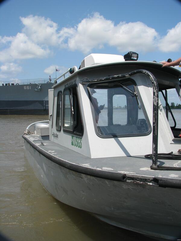
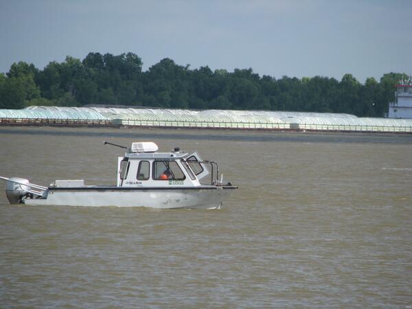
The Butta Bean-150
The Butta Bean-150, one of the USGS Louisiana Water Science Center's fleet. She measures 23 feet long and is used to take streamflow and water quality measurements.
The Butta Bean-150, one of the USGS Louisiana Water Science Center's fleet. She measures 23 feet long and is used to take streamflow and water quality measurements.
USGS Baton Rouge Streamgage
The USGS streamgage at the Baton Rouge City Docks.
The USGS streamgage at the Baton Rouge City Docks.
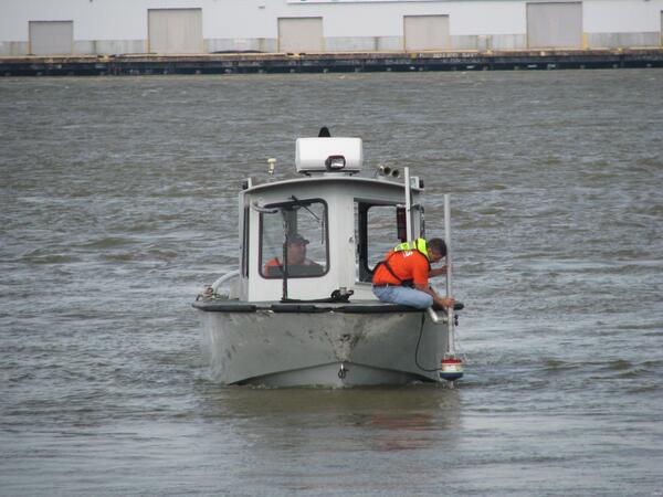
USGS Takes Streamflow Measurements
USGS hydrologist Todd Baumann makes a streamflow measurement of the Mississippi River aboard the Butta Bean during the 2011 Flood. USGS makes streamflow measurements by using an Acoustic Doppler Current Profiler (ADCP), which emits soundwaves through the water column. These soundwaves rebound off particles in the water until they reach the river bottom.
USGS hydrologist Todd Baumann makes a streamflow measurement of the Mississippi River aboard the Butta Bean during the 2011 Flood. USGS makes streamflow measurements by using an Acoustic Doppler Current Profiler (ADCP), which emits soundwaves through the water column. These soundwaves rebound off particles in the water until they reach the river bottom.

2011 Spring Flood
A USGS streamgage station lies mostly submerged. Following rising floodwaters during the 2011 flood, USGS crews removed sensitive streamgage equipment and replaced them with special, pressure-operated streamgage monitoring equipment that could survive being inundated with water.
A USGS streamgage station lies mostly submerged. Following rising floodwaters during the 2011 flood, USGS crews removed sensitive streamgage equipment and replaced them with special, pressure-operated streamgage monitoring equipment that could survive being inundated with water.

2011 Spring Flood
Left to Right: Bill Stiles, Penny Frederick, George Arcement, Dan Kroes, Phil Turnipseed
Left to Right: Bill Stiles, Penny Frederick, George Arcement, Dan Kroes, Phil Turnipseed

2011 Spring Flood
Left to Right: Phil Turnipseed, T Bradley Keith
Left to Right: Phil Turnipseed, T Bradley Keith

2011 Spring Flood
Left to Right: Bill Stiles, Dan Kroes
Left to Right: Bill Stiles, Dan Kroes

2011 Spring Flood
A herd of deer swim across the Atchafalaya River (Main Channel). Rising floodwaters have forced many creatures from their traditional habitats. Deer, raccoons, alligators, and many other traditionally forest-dwelling creatures have been seen swimming across areas that had formerly been dry land.
A herd of deer swim across the Atchafalaya River (Main Channel). Rising floodwaters have forced many creatures from their traditional habitats. Deer, raccoons, alligators, and many other traditionally forest-dwelling creatures have been seen swimming across areas that had formerly been dry land.

2011 Spring Flood
A USGS streamgage station lies mostly submerged. Following rising floodwaters during the 2011 flood, USGS crews removed sensitive streamgage equipment and replaced them with special, pressure-operated streamgage monitoring equipment that could survive being inundated with water.
A USGS streamgage station lies mostly submerged. Following rising floodwaters during the 2011 flood, USGS crews removed sensitive streamgage equipment and replaced them with special, pressure-operated streamgage monitoring equipment that could survive being inundated with water.

2011 Spring Flood
USGS Louisiana Water Science Center Director George Arcement looks at a houseboat parked on the north end of Lake Murphy. Houseboats are a common feature in the Atchafalaya Basin, where people live in them year round, or merely keep them as a hunting or vacation camp.
USGS Louisiana Water Science Center Director George Arcement looks at a houseboat parked on the north end of Lake Murphy. Houseboats are a common feature in the Atchafalaya Basin, where people live in them year round, or merely keep them as a hunting or vacation camp.

2011 Spring Flood
Invasive Giant Salvinia clogs one end of Lake Murphy. Lake Murphy is home to three of Louisiana's most problematic invasive aquatic plant species: Giant Salvinia, Water Hyacinth, and Hydrilla. As the record-setting 2011 floodwaters push through the Atchafalaya Basin, USGS crews are monitoring these invasive species to see what effects the water have on them.
Invasive Giant Salvinia clogs one end of Lake Murphy. Lake Murphy is home to three of Louisiana's most problematic invasive aquatic plant species: Giant Salvinia, Water Hyacinth, and Hydrilla. As the record-setting 2011 floodwaters push through the Atchafalaya Basin, USGS crews are monitoring these invasive species to see what effects the water have on them.

2011 Spring Flood
Invasive species Giant Salvinia and Water Hyacinth clog one end of Lake Murphy. Lake Murphy is home to three of Louisiana’s most problematic invasive aquatic plant species: Giant Salvinia, Water Hyacinth, and Hydrilla.
Invasive species Giant Salvinia and Water Hyacinth clog one end of Lake Murphy. Lake Murphy is home to three of Louisiana’s most problematic invasive aquatic plant species: Giant Salvinia, Water Hyacinth, and Hydrilla.

2011 Spring Flood
Invasive species Giant Salvinia, Hydrilla, and Water Hyacinth clog one end of Lake Murphy. Lake Murphy is home to these three of Louisiana’s most problematic invasive aquatic plant species. As the record-setting 2011 floodwaters push through the Atchafalaya Basin, USGS crews are monitoring these invasive species to see what effects the water have on them.
Invasive species Giant Salvinia, Hydrilla, and Water Hyacinth clog one end of Lake Murphy. Lake Murphy is home to these three of Louisiana’s most problematic invasive aquatic plant species. As the record-setting 2011 floodwaters push through the Atchafalaya Basin, USGS crews are monitoring these invasive species to see what effects the water have on them.
Science and Products
Filter Total Items: 845
Career of the Cryosphere
An interview with USGS scientist emeritus Richie Williams about his career studying the Earth's cryosphere with remote sensing technology.
An interview with USGS scientist emeritus Richie Williams about his career studying the Earth's cryosphere with remote sensing technology.
USGS Releases Latest Bakken Oil and Gas Assessment
On April 30, 2013, USGS released an updated assessment of the Bakken Formation of North Dakota and Montana as part of the National Oil and Gas Assessment.
On April 30, 2013, USGS released an updated assessment of the Bakken Formation of North Dakota and Montana as part of the National Oil and Gas Assessment.
USGS Releases Resource Estimate for Afghanistan Rare Earth Prospect
The U.S. Geological Survey estimates at least 1 million metric tonnes of rare earth element resources within the Khanneshin carbonatite in Helmand Province, Afghanistan. This estimate comes from a 2009-2011 USGS study funded by the Department of Defense's Task Force for Business and Stability Operations.
The U.S. Geological Survey estimates at least 1 million metric tonnes of rare earth element resources within the Khanneshin carbonatite in Helmand Province, Afghanistan. This estimate comes from a 2009-2011 USGS study funded by the Department of Defense's Task Force for Business and Stability Operations.
USGS Takes Streamflow Measurements
USGS crews aboard the Butta Bean measure streamflow on the Mississippi River during the 2011 Flood. At the height of the flood, USGS crews are out every other day taking streamflow measurements to ensure the US Army Corps of Engineers has accurate, up-to-date information with which to base its river management decisions.
USGS crews aboard the Butta Bean measure streamflow on the Mississippi River during the 2011 Flood. At the height of the flood, USGS crews are out every other day taking streamflow measurements to ensure the US Army Corps of Engineers has accurate, up-to-date information with which to base its river management decisions.
Tiger Dams Reinforce Baton Rouge Levees
Tiger Dams line the Baton Rouge Mississippi River levee during the 2011 Flood. Previously used to prevent oil from reaching Louisiana's coast during the 2010 Deepwater Horizon oil spill, these Tiger Dams are filled with water and reinforced with sandbags to give the Baton Rouge Mississippi River levee an extra foot of height. This additional height is pr
Tiger Dams line the Baton Rouge Mississippi River levee during the 2011 Flood. Previously used to prevent oil from reaching Louisiana's coast during the 2010 Deepwater Horizon oil spill, these Tiger Dams are filled with water and reinforced with sandbags to give the Baton Rouge Mississippi River levee an extra foot of height. This additional height is pr
George Arcement Shows Locations of USGS Streamgages
USGS Louisiana Water Science Center Director George Arcement shows the locations of USGS' streamgage network to WAFB Meteorologist Jay Grymes. USGS maintains more than 30 real-time streamgages throughout the area affected by the 2011 Flood.
USGS Louisiana Water Science Center Director George Arcement shows the locations of USGS' streamgage network to WAFB Meteorologist Jay Grymes. USGS maintains more than 30 real-time streamgages throughout the area affected by the 2011 Flood.
George Arcement Demonstrates the ADCP
USGS Water Science Center Director George Arcement demonstrates the Acoustic Doppler Current Profiler (ADCP) to legislative staffers. USGS uses the ADCP to make streamflow measurements. The ADCP emits soundwaves through the water column, which rebound off particles in the water until they reach the river bottom.
USGS Water Science Center Director George Arcement demonstrates the Acoustic Doppler Current Profiler (ADCP) to legislative staffers. USGS uses the ADCP to make streamflow measurements. The ADCP emits soundwaves through the water column, which rebound off particles in the water until they reach the river bottom.
The Butta Bean-150
The Butta Bean-150, one of the USGS Louisiana Water Science Center's fleet. She measures 23 feet long and is used to take streamflow and water quality measurements.
The Butta Bean-150, one of the USGS Louisiana Water Science Center's fleet. She measures 23 feet long and is used to take streamflow and water quality measurements.
USGS Baton Rouge Streamgage
The USGS streamgage at the Baton Rouge City Docks.
The USGS streamgage at the Baton Rouge City Docks.
USGS Takes Streamflow Measurements
USGS hydrologist Todd Baumann makes a streamflow measurement of the Mississippi River aboard the Butta Bean during the 2011 Flood. USGS makes streamflow measurements by using an Acoustic Doppler Current Profiler (ADCP), which emits soundwaves through the water column. These soundwaves rebound off particles in the water until they reach the river bottom.
USGS hydrologist Todd Baumann makes a streamflow measurement of the Mississippi River aboard the Butta Bean during the 2011 Flood. USGS makes streamflow measurements by using an Acoustic Doppler Current Profiler (ADCP), which emits soundwaves through the water column. These soundwaves rebound off particles in the water until they reach the river bottom.
2011 Spring Flood
A USGS streamgage station lies mostly submerged. Following rising floodwaters during the 2011 flood, USGS crews removed sensitive streamgage equipment and replaced them with special, pressure-operated streamgage monitoring equipment that could survive being inundated with water.
A USGS streamgage station lies mostly submerged. Following rising floodwaters during the 2011 flood, USGS crews removed sensitive streamgage equipment and replaced them with special, pressure-operated streamgage monitoring equipment that could survive being inundated with water.
2011 Spring Flood
Left to Right: Bill Stiles, Penny Frederick, George Arcement, Dan Kroes, Phil Turnipseed
Left to Right: Bill Stiles, Penny Frederick, George Arcement, Dan Kroes, Phil Turnipseed
2011 Spring Flood
Left to Right: Phil Turnipseed, T Bradley Keith
Left to Right: Phil Turnipseed, T Bradley Keith
2011 Spring Flood
Left to Right: Bill Stiles, Dan Kroes
Left to Right: Bill Stiles, Dan Kroes
2011 Spring Flood
A herd of deer swim across the Atchafalaya River (Main Channel). Rising floodwaters have forced many creatures from their traditional habitats. Deer, raccoons, alligators, and many other traditionally forest-dwelling creatures have been seen swimming across areas that had formerly been dry land.
A herd of deer swim across the Atchafalaya River (Main Channel). Rising floodwaters have forced many creatures from their traditional habitats. Deer, raccoons, alligators, and many other traditionally forest-dwelling creatures have been seen swimming across areas that had formerly been dry land.
2011 Spring Flood
A USGS streamgage station lies mostly submerged. Following rising floodwaters during the 2011 flood, USGS crews removed sensitive streamgage equipment and replaced them with special, pressure-operated streamgage monitoring equipment that could survive being inundated with water.
A USGS streamgage station lies mostly submerged. Following rising floodwaters during the 2011 flood, USGS crews removed sensitive streamgage equipment and replaced them with special, pressure-operated streamgage monitoring equipment that could survive being inundated with water.
2011 Spring Flood
USGS Louisiana Water Science Center Director George Arcement looks at a houseboat parked on the north end of Lake Murphy. Houseboats are a common feature in the Atchafalaya Basin, where people live in them year round, or merely keep them as a hunting or vacation camp.
USGS Louisiana Water Science Center Director George Arcement looks at a houseboat parked on the north end of Lake Murphy. Houseboats are a common feature in the Atchafalaya Basin, where people live in them year round, or merely keep them as a hunting or vacation camp.
2011 Spring Flood
Invasive Giant Salvinia clogs one end of Lake Murphy. Lake Murphy is home to three of Louisiana's most problematic invasive aquatic plant species: Giant Salvinia, Water Hyacinth, and Hydrilla. As the record-setting 2011 floodwaters push through the Atchafalaya Basin, USGS crews are monitoring these invasive species to see what effects the water have on them.
Invasive Giant Salvinia clogs one end of Lake Murphy. Lake Murphy is home to three of Louisiana's most problematic invasive aquatic plant species: Giant Salvinia, Water Hyacinth, and Hydrilla. As the record-setting 2011 floodwaters push through the Atchafalaya Basin, USGS crews are monitoring these invasive species to see what effects the water have on them.
2011 Spring Flood
Invasive species Giant Salvinia and Water Hyacinth clog one end of Lake Murphy. Lake Murphy is home to three of Louisiana’s most problematic invasive aquatic plant species: Giant Salvinia, Water Hyacinth, and Hydrilla.
Invasive species Giant Salvinia and Water Hyacinth clog one end of Lake Murphy. Lake Murphy is home to three of Louisiana’s most problematic invasive aquatic plant species: Giant Salvinia, Water Hyacinth, and Hydrilla.
2011 Spring Flood
Invasive species Giant Salvinia, Hydrilla, and Water Hyacinth clog one end of Lake Murphy. Lake Murphy is home to these three of Louisiana’s most problematic invasive aquatic plant species. As the record-setting 2011 floodwaters push through the Atchafalaya Basin, USGS crews are monitoring these invasive species to see what effects the water have on them.
Invasive species Giant Salvinia, Hydrilla, and Water Hyacinth clog one end of Lake Murphy. Lake Murphy is home to these three of Louisiana’s most problematic invasive aquatic plant species. As the record-setting 2011 floodwaters push through the Atchafalaya Basin, USGS crews are monitoring these invasive species to see what effects the water have on them.