
Little Missouri River near Camp Area C at Albert Pike Recreation Area, Arkansas (photograph by Daniel M. Wagner, U.S. Geological Survey).
Images
Images from Region 4.
Filter Total Items: 182

Little Missouri River near Camp Area C at Albert Pike Recreation Area
Little Missouri River near Camp Area C at Albert Pike Recreation Area, Arkansas (photograph by Daniel M. Wagner, U.S. Geological Survey).

WRP St. Landry Parish, Louisiana
Wetlands Reserve Program site in St. Landry Parish, Louisiana. Changes in a local river resulted in the landowner’s fields flooding on a regular basis. The landowner worked through the USDA Natural Resources Conservation Service to restore his fields to their natural wetland state.
Wetlands Reserve Program site in St. Landry Parish, Louisiana. Changes in a local river resulted in the landowner’s fields flooding on a regular basis. The landowner worked through the USDA Natural Resources Conservation Service to restore his fields to their natural wetland state.

Oil Spill Samples Arrive from Louisiana
On April 20, 2010, the Deepwater Horizon Drilling Platform exploded and sank, causing the largest oil spill yet recorded. Samples from the oil spill were collected by Louisiana USGS scientists Greg Swayze and Charlie Demas and sent for analysis in Menlo Park, CA.
On April 20, 2010, the Deepwater Horizon Drilling Platform exploded and sank, causing the largest oil spill yet recorded. Samples from the oil spill were collected by Louisiana USGS scientists Greg Swayze and Charlie Demas and sent for analysis in Menlo Park, CA.

Photo of subcore tubes inserted into mud before they are removed
Photo of subcore tubes inserted into mud before they are removed.
Photo of subcore tubes inserted into mud before they are removed.

Photo of researchers with giant box core on the deck of the ship
Photo of researchers positioning giant box core in hoist on deck of the research vessel
Photo of researchers positioning giant box core in hoist on deck of the research vessel

Photo of researchers opening hoist on deck, showing giant box core
Photo of researchers opening hoist, showing giant box core, on deck of the research vessel
Photo of researchers opening hoist, showing giant box core, on deck of the research vessel

Photo of researchers looking at mud in the giant box core
Photo of researchers looking at mud in the giant box core before beginning to take subcores
Photo of researchers looking at mud in the giant box core before beginning to take subcores

Photo of researchers looking at mud in the giant box core
Photo of researchers looking at mud in the giant box core before beginning to take subcores
Photo of researchers looking at mud in the giant box core before beginning to take subcores

Photo of 6" and 4" subcores sampled from a giant box core
Photograph of 6" and 4" subcores sampled from a giant box core.
Photograph of 6" and 4" subcores sampled from a giant box core.

Big Sioux River at Akron, Iowa, 2010
Flooding conditions at USGS streamgage 06485500, Big Sioux River at Arkon, Iowa, on March 17, 2010. Daily mean streamflow on this date was more than 30,000 cubic feet per second.
Flooding conditions at USGS streamgage 06485500, Big Sioux River at Arkon, Iowa, on March 17, 2010. Daily mean streamflow on this date was more than 30,000 cubic feet per second.

Big Sioux River at Akron, Iowa, 2010
U.S. Geological Survey hydrologic technician measuring streamflow at the Big Sioux River at Arkon, Iowa, on March 17, 2010, during flooding conditions.
U.S. Geological Survey hydrologic technician measuring streamflow at the Big Sioux River at Arkon, Iowa, on March 17, 2010, during flooding conditions.

Photo of planktic foraminifers from the sediment trap
Photograph of planktic foraminifers collected from the sediment trap. Magnified 255x.
Photograph of planktic foraminifers collected from the sediment trap. Magnified 255x.

Stream Mycotoxin Concentrations were Highest During Spring Snowmelt
Highest stream mycotoxin concentrations were observed during spring snowmelt conditions in agricultural settings such as pictured in this Iowa stream.
Highest stream mycotoxin concentrations were observed during spring snowmelt conditions in agricultural settings such as pictured in this Iowa stream.

Baseflow measurements of field parameters
The team of USGS scientists collected stream water samples before and after rainfall events for this study. In this photo a USGS scientist is taking measurements of field parameters (dissolved oxygen, water temperature, specific conductance, and pH) from New York Branch, Iowa, at low flow (baseflow) conditions.
The team of USGS scientists collected stream water samples before and after rainfall events for this study. In this photo a USGS scientist is taking measurements of field parameters (dissolved oxygen, water temperature, specific conductance, and pH) from New York Branch, Iowa, at low flow (baseflow) conditions.

WRP Morehouse Parish, Louisiana
Wetlands Reserve Program site in Morehouse Parish, Louisiana. Green tree frogs rest on a Wetlands Reserve Program easement boundary sign in Morehouse Parish, Louisiana.
Wetlands Reserve Program site in Morehouse Parish, Louisiana. Green tree frogs rest on a Wetlands Reserve Program easement boundary sign in Morehouse Parish, Louisiana.

Farm in Iowa in morning mist amid cornfield
Iowa farm in a cornfield in the early morning mist. USGS research investigates the effects of agricultural use of fertilizers, pesticides, and other chemicals in the quality of surface water and groundwater.
Iowa farm in a cornfield in the early morning mist. USGS research investigates the effects of agricultural use of fertilizers, pesticides, and other chemicals in the quality of surface water and groundwater.

Farm in Iowa with silos
This farm in Iowa sits amid a field of corn. USGS researches the effects of agricultural use of fertilizers, pesticides, and other chemicals on surface-water and groundwater quality.
This farm in Iowa sits amid a field of corn. USGS researches the effects of agricultural use of fertilizers, pesticides, and other chemicals on surface-water and groundwater quality.

Flood of March 19, 2008 at Buffalo River, Ark.
B.K. Martin, hydrologic technician in the Little Rock office of the USGS Lower Mississippi-Gulf Water Science Center, measuring streamflow with an acoustic doppler current profiler during flood of March 19, 2008, at USGS streamflow-gaging station 07056000, Buffalo River near St. Joe, Arkansas. Photograph by W.E.
B.K. Martin, hydrologic technician in the Little Rock office of the USGS Lower Mississippi-Gulf Water Science Center, measuring streamflow with an acoustic doppler current profiler during flood of March 19, 2008, at USGS streamflow-gaging station 07056000, Buffalo River near St. Joe, Arkansas. Photograph by W.E.

Measuring streamflow with an acoustic doppler current profiler
B.K. Martin, hydrologic technician in the Little Rock office of the USGS Lower Mississippi-Gulf Water Science Center, measuring streamflow with an acoustic doppler current profiler during flood of March 19, 2008, at USGS streamflow-gaging station 07056000, Buffalo River near St. Joe, Arkansas. Photograph by W.E.
B.K. Martin, hydrologic technician in the Little Rock office of the USGS Lower Mississippi-Gulf Water Science Center, measuring streamflow with an acoustic doppler current profiler during flood of March 19, 2008, at USGS streamflow-gaging station 07056000, Buffalo River near St. Joe, Arkansas. Photograph by W.E.

White River at Calico Rock, Arkansas, during flood of March 19, 2008
White River at Calico Rock, Arkansas, during flood of March 19, 2008. Photograph by Daniel M. Wagner, U.S. Geological Survey.
White River at Calico Rock, Arkansas, during flood of March 19, 2008. Photograph by Daniel M. Wagner, U.S. Geological Survey.
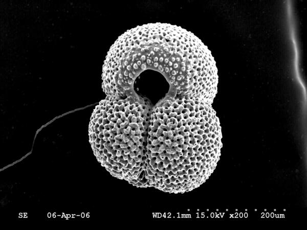
Scanning electron microsope image of the planktic foram Globiger ruber
Scanning electron microsope image of the planktic foraminifer Globigerinoides ruber
Scanning electron microsope image of the planktic foraminifer Globigerinoides ruber