
Zoomed-in view of the current visitor viewing area at the end of Hwy 130.
Images
Kīlauea images of eruptive activity, field work, and more.
Filter Total Items: 2296

Kilauea Lava Flow
Zoomed-in view of the current visitor viewing area at the end of Hwy 130.

Kilauea Lava Flow
View looking south at the currently active flow crossing the coastal plain west of Kalapana. The new flow is the silvery lava crossing the photo from lower right to top center where the flow front is burning vegetation. The end of Hwy 130 is visible at upper left.
View looking south at the currently active flow crossing the coastal plain west of Kalapana. The new flow is the silvery lava crossing the photo from lower right to top center where the flow front is burning vegetation. The end of Hwy 130 is visible at upper left.

Aerial Photo of Kilauea Lava Flow
Distant view looking north at the active flow as it crossing the coastal plain and approaches the ocean. Houses in the Kalapana Gardens subdivision are visible to the right. The lava tube feeding lava to the flow front is delineated by the points of fume at upper left.
Distant view looking north at the active flow as it crossing the coastal plain and approaches the ocean. Houses in the Kalapana Gardens subdivision are visible to the right. The lava tube feeding lava to the flow front is delineated by the points of fume at upper left.

Kilauea Flow Field
No surface flows were active anywhere on the flow field today, due to summit deflation and a reduction in lava supply over the past few days. Summit inflation resumed yesterday, and an increase in lava supply should lead to resumed breakouts over the next several days.
No surface flows were active anywhere on the flow field today, due to summit deflation and a reduction in lava supply over the past few days. Summit inflation resumed yesterday, and an increase in lava supply should lead to resumed breakouts over the next several days.

Kilauea's east rift zone eruption site
Kīlauea's east rift zone eruption site. Pu`u `Ō `ō is to the right, and the TEB vent and upper tube system is to the left and behind Pu`u `Ō `ō.
Kīlauea's east rift zone eruption site. Pu`u `Ō `ō is to the right, and the TEB vent and upper tube system is to the left and behind Pu`u `Ō `ō.

Lava flow
The terminus of the more vigorous western branch of the active flow on the western side of the TEB flow field near the top of the Royal Gardens subdivision.
The terminus of the more vigorous western branch of the active flow on the western side of the TEB flow field near the top of the Royal Gardens subdivision.

Aerial of Active Kilauea Area
An aerial view looking north at two active areas of Kīlauea. Pu`u `Ō `ō crater is in the foreground, Mauna Loa (left) and Mauna Kea (right) are in the background. The fume source near the base of Mauna Loa (at Kīlauea's summit) is from the Halema`uma`u Overlook vent.
An aerial view looking north at two active areas of Kīlauea. Pu`u `Ō `ō crater is in the foreground, Mauna Loa (left) and Mauna Kea (right) are in the background. The fume source near the base of Mauna Loa (at Kīlauea's summit) is from the Halema`uma`u Overlook vent.

Explosive Kilauea Boulder
This large rock at the Kīlauea Overlook in Hawai‘i Volcanoes National Park was ejected ballistically in 1790, or soon thereafter, from Kilauea Volcano's summit caldera when it was more than 600 meters (2000 feet) deep.
This large rock at the Kīlauea Overlook in Hawai‘i Volcanoes National Park was ejected ballistically in 1790, or soon thereafter, from Kilauea Volcano's summit caldera when it was more than 600 meters (2000 feet) deep.

Aerial view of Pu‘u ‘Ō‘ō and surrounding features
Aerial view of Pu‘u ‘Ō‘ō and surrounding features.
Aerial view of Pu‘u ‘Ō‘ō and surrounding features.

Early morning glow from Overlook vent in Halema‘uma‘u, Kīlauea
Incandescence from the lava lake surface (out of view) reflects an awesome glow on the gas plume rising from the lake surface.
Incandescence from the lava lake surface (out of view) reflects an awesome glow on the gas plume rising from the lake surface.

Lava Enters The Ocean At Kilauea Volcano, Hawai'i
Lava from the Pu'u 'Ō'ō-Kupaianaha eruption, active since 1983, enters the ocean on the south flank of Kīlauea Volcano.
Lava from the Pu'u 'Ō'ō-Kupaianaha eruption, active since 1983, enters the ocean on the south flank of Kīlauea Volcano.

USGS Hawaiian Volcano Observatory geologist Janet Babb
The degassing lava lake within Halema‘uma‘u at the summit of Kīlauea was a fitting backdrop in 2009 for USGS Hawaiian Volcano Observatory geologist Janet Babb, who later co-produced a video about the summit eruption.
The degassing lava lake within Halema‘uma‘u at the summit of Kīlauea was a fitting backdrop in 2009 for USGS Hawaiian Volcano Observatory geologist Janet Babb, who later co-produced a video about the summit eruption.

Side-by-side comparison of the NW wall of Kīlauea Caldera on a clea...
Side-by-side comparison of the northwest wall of Kīlauea Caldera on a clear day (left) and a day with thick vog (right). HVO observation tower and building can be seen near the center in each photo.
Side-by-side comparison of the northwest wall of Kīlauea Caldera on a clear day (left) and a day with thick vog (right). HVO observation tower and building can be seen near the center in each photo.

Vog obscures view during slack or no tradewinds at summit of Kīlauea
Vog obscures view during slack or no tradewinds at the summit of Kīlauea Volcano, Hawai‘i
Vog obscures view during slack or no tradewinds at the summit of Kīlauea Volcano, Hawai‘i

Geologist on rim of Halema‘uma‘u downloading camera images, Kīlauea...
HVO geologist downloads images collected with infrared cameras set up on the rim of Halema‘uma‘u Crater. The cameras are aimed at an erupting lava lake to conduct a thermal survey of the lake's surface.
HVO geologist downloads images collected with infrared cameras set up on the rim of Halema‘uma‘u Crater. The cameras are aimed at an erupting lava lake to conduct a thermal survey of the lake's surface.

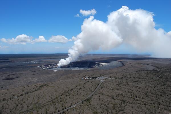
USGS HVO, Kīlauea, Hawaii
The Hawaiian Volcano Observatory perched on the west rim of Kīlauea Volcano's summit caldera, overlooks Halema‘uma‘u Crater, where a new vent that opened in March 2008 emits a volcanic gas plume.
The Hawaiian Volcano Observatory perched on the west rim of Kīlauea Volcano's summit caldera, overlooks Halema‘uma‘u Crater, where a new vent that opened in March 2008 emits a volcanic gas plume.

HVO on rim of Kīlauea's summit caldera overlooking Halema‘uma‘u, Ha...
The Hawaiian Volcano Observatory, the first volcano observatory in the United States, is located on the west rim of Kīlauea Volcano's summit caldera in Hawai‘i Volcanoes National Park. A volcanic gas plume rises from a vent that opened in 2008 at the base of the south wall of Halema‘uma‘u Crater. Crater Rim Drive in foreground.
The Hawaiian Volcano Observatory, the first volcano observatory in the United States, is located on the west rim of Kīlauea Volcano's summit caldera in Hawai‘i Volcanoes National Park. A volcanic gas plume rises from a vent that opened in 2008 at the base of the south wall of Halema‘uma‘u Crater. Crater Rim Drive in foreground.

HVO on rim of Kīlauea's summit caldera overlooking Halema‘uma‘u, Ha...
The U.S. Geological Survey's Hawaiian Volcano Observatory, the first volcano observatory in the United States, is located on the west rim of Kīlauea Volcano's summit caldera in Hawai‘i Volcanoes National Park. A volcanic gas plume rises from a vent that opened in 2008 at the base of the south wall of Halema‘uma‘u Crater. Crater Rim Drive in foreground.
The U.S. Geological Survey's Hawaiian Volcano Observatory, the first volcano observatory in the United States, is located on the west rim of Kīlauea Volcano's summit caldera in Hawai‘i Volcanoes National Park. A volcanic gas plume rises from a vent that opened in 2008 at the base of the south wall of Halema‘uma‘u Crater. Crater Rim Drive in foreground.

USGS Hawaiian Volcano Observatory Monitors Kilauea's Summit Eruption
The USGS Hawaiian Volcano Observatory (foreground) is located on the caldera rim of Kilauea Volcano, Hawai'i—the most active volcano in the world. The observatory's location provides an excellent view of summit eruptive activity, which began in 2008.
The USGS Hawaiian Volcano Observatory (foreground) is located on the caldera rim of Kilauea Volcano, Hawai'i—the most active volcano in the world. The observatory's location provides an excellent view of summit eruptive activity, which began in 2008.
The USGS Hawaiian Volcano Observatory Monitors Kilauea's Summit Eruption
The USGS Hawaiian Volcano Observatory (foreground) is located on the caldera rim of Kilauea Volcano, Hawai'ithe most active volcano in the world. The observatory's location provides an excellent view of summit eruptive activity, which began in 2008.
The USGS Hawaiian Volcano Observatory (foreground) is located on the caldera rim of Kilauea Volcano, Hawai'ithe most active volcano in the world. The observatory's location provides an excellent view of summit eruptive activity, which began in 2008.

Nighttime view of tephra-jet explosion, Kīlauea, Hawai‘i
Incandescent arcs trace the path of lava fragments cast out during a tephra-jet explosion at the Waikupanaha ocean entry in 2008. This is a relatively small explosion, reaching a few tens of meters (yards) height, while one earlier in the day was nearly 70 meters (230 ft) in height.
Incandescent arcs trace the path of lava fragments cast out during a tephra-jet explosion at the Waikupanaha ocean entry in 2008. This is a relatively small explosion, reaching a few tens of meters (yards) height, while one earlier in the day was nearly 70 meters (230 ft) in height.