
Mount St. Helens: Land of Transformation video shows the changes to the landscape from before the May 18, 1980 eruption to today (2024).
Multimedia
Images

Mount St. Helens: Land of Transformation
Mount St. Helens: Land of Transformation video shows the changes to the landscape from before the May 18, 1980 eruption to today (2024).

Lahar Evacuation Drill
During the March 21, 2024 lahar evacuation drills, thousands of students walked to the Washington State Fairgrounds in Puyallup, Washington to practice evacuating from a lahar generated by Mount Rainier. A lahar, or volcanic mudflow, could reach this area in about 3 hours.
During the March 21, 2024 lahar evacuation drills, thousands of students walked to the Washington State Fairgrounds in Puyallup, Washington to practice evacuating from a lahar generated by Mount Rainier. A lahar, or volcanic mudflow, could reach this area in about 3 hours.

Surface nodal seismometer installation in Turkiye
USGS installed an array of seismometers in a field in Gaziantep, Turkiye in order to record ambient noise and earthquakes, including the aftershocks of the devastating earthquakes of 2023. Robert Sickler of the USGS in the foreground and an AFAD employee in the background.
USGS installed an array of seismometers in a field in Gaziantep, Turkiye in order to record ambient noise and earthquakes, including the aftershocks of the devastating earthquakes of 2023. Robert Sickler of the USGS in the foreground and an AFAD employee in the background.

"Bridging the Gap from Communicating Risk to Reducing Risk" screenshot
Screenshot from Lucy Jones' presentation called "Bridging the Gap from Communicating Risk to Reducing Risk." Presentation available on the USGS website.
Screenshot from Lucy Jones' presentation called "Bridging the Gap from Communicating Risk to Reducing Risk." Presentation available on the USGS website.

地震发生区域: 纽约市的地震
地震发生区域
国家地震灾害模型,2023 年
纽约市的地震
您知道自己生活在“地震带”吗?这是真 的。纽约市等地过去曾发生过地震,将来 还会发生。如果您感到地面在震动,请确 保知道怎么做:趴下、掩护和稳住!
如果您感觉到地面在震动
趴下 掩护 稳住
规模最大的地震 - 纽约市 - 1884年8月10日 - 震级 5.2
地震发生区域
国家地震灾害模型,2023 年
纽约市的地震
您知道自己生活在“地震带”吗?这是真 的。纽约市等地过去曾发生过地震,将来 还会发生。如果您感到地面在震动,请确 保知道怎么做:趴下、掩护和稳住!
如果您感觉到地面在震动
趴下 掩护 稳住
规模最大的地震 - 纽约市 - 1884年8月10日 - 震级 5.2

CÁC TRẬN ĐỘNG ĐẤT XẢY RA Ở ĐÂU: ĐỘNG ĐẤT TẠI THÀNH PHỐ NEW YORK
CÁC TRẬN ĐỘNG ĐẤT XẢY RA Ở ĐÂU
Theo Mô Hình Cảnh Báo Nguy Hiểm Động Đất Toàn Quốc, 2023
ĐỘNG ĐẤT TẠI THÀNH PHỐ NEW YORK
CÁC TRẬN ĐỘNG ĐẤT XẢY RA Ở ĐÂU
Theo Mô Hình Cảnh Báo Nguy Hiểm Động Đất Toàn Quốc, 2023
ĐỘNG ĐẤT TẠI THÀNH PHỐ NEW YORK
Videos
")
Mount St. Helens VS Yellowstone (Yellowstone Monthly Update - May 2024)
Mount St. Helens and Yellowstone are two of the most well-known volcanoes in the United States. They have some pretty obvious differences, but they have some similarities as well. So, just how similar are Mount St. Helens and Yellowstone?
Mount St. Helens and Yellowstone are two of the most well-known volcanoes in the United States. They have some pretty obvious differences, but they have some similarities as well. So, just how similar are Mount St. Helens and Yellowstone?
Mount St. Helens: Land of Transformation
Mt St. Helens before 1980, Land of Transformation
A stylistic interpretation of pre eruption snowcapped Mount St Helens as seen from a blue Spirit Lake with green rolling hills.
Text changes to May 18, 1980, Eruption. There is a grey explosion of rocks and smoke coming out the top of Mt St Helens. The hills and water are grey and brown.
")
Press Conference — M 4.8 near Whitehouse Station, NJ (afternoon)
Press conference held at 2:30 pm EST on April 5, 2024.
Press conference held at 2:30 pm EST on April 5, 2024.

Press Conference — M 4.8 near Whitehouse Station, NJ
Press conference held at 12pm EST April 5, 2024.
Press conference held at 12pm EST April 5, 2024.
")
Ship Wrecked in Yellowstone Lake? (Yellowstone Volcano Monthly Update - April 2024)
Is there a wrecked ship rising out of Yellowstone Lake or is it an April Fool's joke? Watch to learn more!
Is there a wrecked ship rising out of Yellowstone Lake or is it an April Fool's joke? Watch to learn more!
Audio

Landers Rupture — Where they were
USGS scientists remember where they were during the 1992 Landers earthquake in Southern California
USGS scientists remember where they were during the 1992 Landers earthquake in Southern California
Landers Rupture — Sue on what it felt like
USGS seismologist Susan Hough recalls what the 1992 Landers earthquake felt like from Pasadena, CA.
USGS seismologist Susan Hough recalls what the 1992 Landers earthquake felt like from Pasadena, CA.
Landers Rupture — Andy on using satellite data
USGS seismologist Andrew Michael talks about the remote location of the 1992 Landers earthquake and how researchers were able to use satellite data to better see the quake’s impacts.
USGS seismologist Andrew Michael talks about the remote location of the 1992 Landers earthquake and how researchers were able to use satellite data to better see the quake’s impacts.
Landers Rupture — Sue on her role after the earthquake and seismic monitoring in Southern CA
USGS seismologist Susan Hough talks about her role following the 1992 Landers earthquake and seismic monitoring stations in Southern California.
USGS seismologist Susan Hough talks about her role following the 1992 Landers earthquake and seismic monitoring stations in Southern California.
Landers Rupture — Scott on what it looked like
USGS field technician Scott Lydeen recalls what the aftermath of the 1992 Landers earthquake looked like.
USGS field technician Scott Lydeen recalls what the aftermath of the 1992 Landers earthquake looked like.
Landers Rupture — Sue on how monitoring networks evolved
USGS seismologist Susan Hough described the Southern California Seismic Network and how it was used for the 1992 Landers earthquake.
USGS seismologist Susan Hough described the Southern California Seismic Network and how it was used for the 1992 Landers earthquake.
Webcams
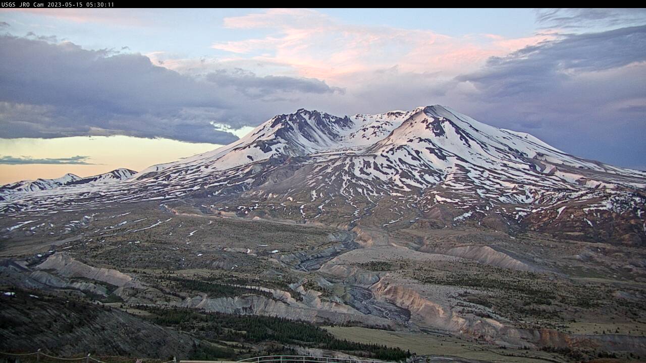
Johnston Ridge Observatory, Mount St. Helens
A debris flow in Mount St.

Nuvuk video camera 2 bright image
Two video cameras are installed atop a utility pole near the northernmost point of land in the United States at Nuvuk (Point Barrow), Alaska. The cameras point northwest toward the Arctic Ocean and the boundary between the Chukchi and Beaufort Seas. Every half hour during daylight hours, the cameras collect snapshots and video for 10 minutes.
Two video cameras are installed atop a utility pole near the northernmost point of land in the United States at Nuvuk (Point Barrow), Alaska. The cameras point northwest toward the Arctic Ocean and the boundary between the Chukchi and Beaufort Seas. Every half hour during daylight hours, the cameras collect snapshots and video for 10 minutes.

Nuvuk video camera 1 dark image
Two video cameras are installed atop a utility pole near the northernmost point of land in the United States at Nuvuk (Point Barrow), Alaska. The cameras point northwest toward the Arctic Ocean and the boundary between the Chukchi and Beaufort Seas. Every half hour during daylight hours, the cameras collect snapshots and video for 10 minutes.
Two video cameras are installed atop a utility pole near the northernmost point of land in the United States at Nuvuk (Point Barrow), Alaska. The cameras point northwest toward the Arctic Ocean and the boundary between the Chukchi and Beaufort Seas. Every half hour during daylight hours, the cameras collect snapshots and video for 10 minutes.

Nuvuk video camera 2 dark image
Two video cameras are installed atop a utility pole near the northernmost point of land in the United States at Nuvuk (Point Barrow), Alaska. The cameras point northwest toward the Arctic Ocean and the boundary between the Chukchi and Beaufort Seas. Every half hour during daylight hours, the cameras collect snapshots and video for 10 minutes.
Two video cameras are installed atop a utility pole near the northernmost point of land in the United States at Nuvuk (Point Barrow), Alaska. The cameras point northwest toward the Arctic Ocean and the boundary between the Chukchi and Beaufort Seas. Every half hour during daylight hours, the cameras collect snapshots and video for 10 minutes.

Nuvuk video camera 2 snapshop
Two video cameras are installed atop a utility pole near the northernmost point of land in the United States at Nuvuk (Point Barrow), Alaska. The cameras point northwest toward the Arctic Ocean and the boundary between the Chukchi and Beaufort Seas. Every half hour during daylight hours, the cameras collect snapshots and video for 10 minutes.
Two video cameras are installed atop a utility pole near the northernmost point of land in the United States at Nuvuk (Point Barrow), Alaska. The cameras point northwest toward the Arctic Ocean and the boundary between the Chukchi and Beaufort Seas. Every half hour during daylight hours, the cameras collect snapshots and video for 10 minutes.

Nuvuk video camera 1 time exposure
Two video cameras are installed atop a utility pole near the northernmost point of land in the United States at Nuvuk (Point Barrow), Alaska. The cameras point northwest toward the Arctic Ocean and the boundary between the Chukchi and Beaufort Seas. Every half hour during daylight hours, the cameras collect snapshots and video for 10 minutes.
Two video cameras are installed atop a utility pole near the northernmost point of land in the United States at Nuvuk (Point Barrow), Alaska. The cameras point northwest toward the Arctic Ocean and the boundary between the Chukchi and Beaufort Seas. Every half hour during daylight hours, the cameras collect snapshots and video for 10 minutes.