
Information Systems
How can I find U.S. Bureau of Mines publications?
Are USGS reports copyrighted?
When should I use a Freedom of Information Act (FOIA) request?
The USGS has developed many tools and techniques for analyzing data and specialized websites for sharing information and products with the public.

Why do USGS earthquake magnitudes differ from those published by other agencies?
Magnitude estimates for a given earthquake can vary between reporting agencies due to differences in methodology, data availability, and inherent uncertainties in seismic data. Individual agencies use magnitude estimation procedures designed to meet the agency's specific needs and monitoring capabilities. Even for well-recorded events, differences in magnitude of 0.2 or 0.3 units are common and...

Why/When does the USGS update the magnitude of an earthquake?
The USGS often updates an earthquake's magnitude in the hours and sometimes days following the event. Updates occur as more data become available for analysis and more time-intensive analysis is performed. Additional updates are possible as part of the standard procedure of assembling a final earthquake catalog. There are physical and operational constraints on how quickly seismic data are...

Can I get on a list to receive an email message when there is an earthquake? How do I sign up for earthquake notifications? Are there any Feeds I can subscribe to?
Please go to the USGS Earthquake Notification Services (ENS) to sign up for free emails or text messages to your phone. Use the default settings or customize ENS to fit your needs. Also check out the many different Earthquake Feeds . ENS is NOT an earthquake early warning system. Messages issued by ENS will almost always arrive after you would feel any shaking. Learn more: How do I sign up for...

Why do some earthquakes disappear from the map/list?
The USGS and networks contributing to the Advance National Seismic System (ANSS) take great effort to provide accurate and timely earthquake information. Occasionally our systems produce erroneous information that is released to the public via our web pages or Earthquake Notification System . These mistakes are generally promptly identified by seismologists, removed from our web pages, and “delete...

Did I feel an earthquake? Can I report feeling an earthquake?
Report an earthquake experience or related observation through the Did You Feel It? citizen science webpage. The best way to do this is to click on the earthquake that you think you felt on one of the lists on the Earthquakes webpage, and then select the "Tell Us!" link. If you don't see the earthquake you think you felt, use the green "Report an Unknown Event" button on our Did You Feel It? page...

Why is the earthquake that was reported/recorded by network X, or that I felt, not on the Latest Earthquakes map/list?
The USGS Latest Earthquakes map and lists show events that have been located by the USGS and contributing agencies within the last 30 days. They should NOT be considered complete lists of all events in the U.S. and adjacent areas and especially should NOT be considered complete lists of all magnitude 4.5 and greater events that occur around the globe. In most cases, we locate and report an...
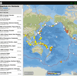
Where can I find current earthquake lists and maps for the world or for a specific area?
The Earthquake Hazards Program Latest Earthquakes Map displays earthquakes in near-realtime and up to the past 30 days of earthquakes. The interface includes three panels: a list of earthquakes, a map, and a settings/options panel. You can pan and zoom the map to view specific areas. Click on an event on the list or map for additional information and a link to the event page with all the details...

Are there geologic maps or publications for where I live?
Detailed geologic mapping has not been completed for the entire United States, but maps are available for most locations. Geologic maps at many scales and from many sources are listed in the National Geologic Map Database . Some geologic maps can be purchased in hard copy through the USGS Store . Download digital geologic maps for entire states from the USGS Mineral Resources Online Geospatial...

Where can I find historical photographs from the Great Surveys of the American West?
A number of images from the "Great Surveys of the American West" can be downloaded through the online USGS Photographic Library . Before the USGS was established by Congress as a part of the Department of Interior, four surveys of the western United States took place between 1867 and 1879. Surveys led by Ferdinand Hayden and John Wesley Powell were sponsored by the Interior Department, and Surveys...

How can I find USGS historical photographs?
The USGS Photographic Library, located at our library in Denver, Colorado , is an archive of still photographs dating from the 1870s and taken by USGS scientists as part of their field studies. The works of pioneer photographers W.H. Jackson, T.H. O’Sullivan, Carleton Watkins, J.K. Hillers, Thomas Moran, A.J. Russell, E.O. Beaman, and William Bell are represented in the collection. Topics include...

How do I get a paper copy of a USGS online document?
Most USGS publications are available in free PDF format through the USGS Publications Warehouse . They are copyright-free, and can be printed at home or at a commercial print shop. If you don't have access to a printer, some USGS reports can be purchased in printed format through the online USGS Store .

How can I find out-of-print USGS publications?
Out-of-print USGS publications and maps, depending on series and date, can be obtained in various ways: Check the USGS Publications Warehouse for online availability. If the publication is listed but does not have a link to a digital version, contact the Publications Warehouse Team to request a digital copy. Borrow from your local public, academic, or corporate library through a request for...