
Jackson Hole Airport groundwater study area map
Images
Images described and linked on this webpage come from a wide variety of USGS science activities and presentations performed by USGS Science Center staff members in the Region 7: Upper Colorado Basin. A search tool is provided to narrow the number of image files shown.
Filter Total Items: 491

Jackson Hole Airport groundwater study area map
Jackson Hole Airport groundwater study area map

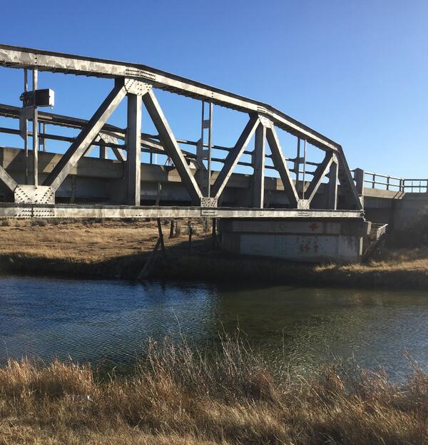
Digital Elevation Model Created by an Unmanned Aerial System
This digital elevation model was created using structure from motion software mounted to an Unmanned Aerial System (UAS) to analyze bridge scour. Studies using UAS have included stream temperature analyses, bird and mammal surveys, coastal change mapping, sandbar habitat surveys, fluvial erosion rates, microclimate mapping, air quality analysis, plant stress as
This digital elevation model was created using structure from motion software mounted to an Unmanned Aerial System (UAS) to analyze bridge scour. Studies using UAS have included stream temperature analyses, bird and mammal surveys, coastal change mapping, sandbar habitat surveys, fluvial erosion rates, microclimate mapping, air quality analysis, plant stress as

Unmanned Aerial System
This small unmanned aerial system with digital camera has been used to create digital elevation models to answer questions about erosion, bridge scour, and other hydraulics analyses.
This small unmanned aerial system with digital camera has been used to create digital elevation models to answer questions about erosion, bridge scour, and other hydraulics analyses.

Unmanned Aerial System in Flight
Small Unmanned Aerial System (UAS) collecting digital photos to create digital elevation models. UAS are an increasingly important tool for monitoring, assessing, and conducting targeted scientific research for the nation.
Small Unmanned Aerial System (UAS) collecting digital photos to create digital elevation models. UAS are an increasingly important tool for monitoring, assessing, and conducting targeted scientific research for the nation.

Dry wash in San Rafael Desert with white surface salts
Dry wash in San Rafael Desert with white surface salts. White efflorescent salts form on the soil surface as water evaporates from the soil leaving the salt at the surface.
Dry wash in San Rafael Desert with white surface salts. White efflorescent salts form on the soil surface as water evaporates from the soil leaving the salt at the surface.

Fathead minnows swimming in an experimental aquarium
Bioactive Chemicals Research Laboratory — Boulder, Colorado. Fathead minnows (Pimephales promelas) swimming in an experimental aquarium. The aquarium is part of an experiment to assess endocrine disruption in fish.
Bioactive Chemicals Research Laboratory — Boulder, Colorado. Fathead minnows (Pimephales promelas) swimming in an experimental aquarium. The aquarium is part of an experiment to assess endocrine disruption in fish.

Aquariums where male fathead minnows were exposed to sewage effluent
Aquariums where male fathead minnows were exposed to the effluent from a wastewater treatment plant
Aquariums where male fathead minnows were exposed to the effluent from a wastewater treatment plant

USGS WY-MT WSC Casper Office
USGS Casper Office

Measuring streamflow in Goose Creek, near Acme, station 06305700
Measuring streamflow in Goose Creek, near Acme, station 06305700
Measuring streamflow in Goose Creek, near Acme, station 06305700

Measuring streamflow under ice, Pass Creek, nr Parkman, WY
Measuring streamflow under ice, Pass Creek, near Parkman, WY, station 06289600
Measuring streamflow under ice, Pass Creek, near Parkman, WY, station 06289600

Cheyenne Wyoming office
Cheyenne Wyoming office

Great Salt Lake, USGS boat at work
USGS scientists check breach on glass-calm Great Salt Lake in surreal light.
USGS scientists check breach on glass-calm Great Salt Lake in surreal light.

Reading stream stage at Bull Lake Creek above Bull Lake streamgage
The wire weight is lowered to determine stage of Bull Lake Creek above Bull Lake
The wire weight is lowered to determine stage of Bull Lake Creek above Bull Lake
Wire weight mounted on bridge crossing Blacks Fork, streamgage 0921920
Wire weight mounted on bridge crossing Blacks Fork, streamgage 09219200
Wire weight mounted on bridge crossing Blacks Fork, streamgage 09219200

Jemez Falls
Jemez Falls located in the Jemez Mountains near Santa Fe, New Mexico
Jemez Falls located in the Jemez Mountains near Santa Fe, New Mexico

Setting up to measure streamflow, Muddy Creek near Dad
Setting up to measure streamflow, Muddy Creek near Dad
Setting up to measure streamflow, Muddy Creek near Dad

Installing new radar sensor and staff plate, Big Sandy River
Installing new radar sensor and staff plate, Big Sandy River
Installing new radar sensor and staff plate, Big Sandy River

Hydro Techs Perform Well Integrity Test
On September 19th, 2017 staff from the USGS NM WSC Albuquerque and Las Cruces offices visited a Climate Response Network (CRN) well just on the east side of the Organ Mountains outside of Las Cruces to receive training on integrity testing groundwater wells.
On September 19th, 2017 staff from the USGS NM WSC Albuquerque and Las Cruces offices visited a Climate Response Network (CRN) well just on the east side of the Organ Mountains outside of Las Cruces to receive training on integrity testing groundwater wells.

Pipetting for DNA analysis - loop-mediated isothermal amplification
Pipetting for DNA analysis using loop-mediated isothermal amplification
Pipetting for DNA analysis using loop-mediated isothermal amplification

Testing the feasibility of real-time eDNA monitoring
Elk are not concerned with our work. USGS and the Monterey Bay Aquarium Research Institute conducted tests of the feasibility of real-time eDNA monitoring at USGS streamgage 06190540 Boiling River at Mammoth,YNP, September 13, 2017.
Elk are not concerned with our work. USGS and the Monterey Bay Aquarium Research Institute conducted tests of the feasibility of real-time eDNA monitoring at USGS streamgage 06190540 Boiling River at Mammoth,YNP, September 13, 2017.

Teton Fault
Mark, Nicole, Rich, Ryan, Dean taking out the "trash" from the base of the trench.
Mark, Nicole, Rich, Ryan, Dean taking out the "trash" from the base of the trench.